![](/images/other/stat-length.png)
- Excursiones
- A pie
- Germany
- Brandemburgo
- Dahme-Spreewald
Dahme-Spreewald, Brandemburgo, A pie: Los mejores itinerarios de excursión, recorridos, paseos y sendas
Dahme-Spreewald: Descubra las mejores excursiones: 95 a pie. Todos estos circuitos, recorridos, itinerarios y actividades al aire libre están disponibles en nuestras aplicaciones SityTrail para smartphone y tablet.
Los mejores recorridos (95)
![Excursión A pie Mittenwalde - Historischer Landweg Rangsdorf-Königs Wusterhausen - Photo](https://media.geolcdn.com/t/350/260/16c944a7-a918-4bec-9b1b-a46eff50e168.jpeg&format=jpg&maxdim=2)
![A pie A pie](https://static1.geolcdn.com/sitytour/trail-icons/100.png)
Km
A pie
![](/images/other/stat-length.png)
![](https://static1.geolcdn.com/siteimages/upload/files/1508320355ic_sort_den_pos_24dp.png)
![](https://static1.geolcdn.com/siteimages/upload/files/1508320355ic_sort_den_neg_24dp.png)
![](https://static1.geolcdn.com/siteimages/upload/files/16400158638029165_repeat_loop_refresh_sync_direction_icon.png)
• Symbol: horizontaler grüner Balken
![Excursión A pie Schwielochsee - Wanderweg Lamsfeld-Klein Liebitz-Lieberose - Photo](https://media.geolcdn.com/t/350/260/cb7d3188-9312-47a7-b0ea-499148eca93b.jpeg&format=jpg&maxdim=2)
![A pie A pie](https://static1.geolcdn.com/sitytour/trail-icons/100.png)
Km
A pie
![](/images/other/stat-length.png)
![](https://static1.geolcdn.com/siteimages/upload/files/1508320355ic_sort_den_pos_24dp.png)
![](https://static1.geolcdn.com/siteimages/upload/files/1508320355ic_sort_den_neg_24dp.png)
![](https://static1.geolcdn.com/siteimages/upload/files/16400158638029165_repeat_loop_refresh_sync_direction_icon.png)
• Symbol: horizintaler grüner Balken auf weißem Quadrat
![Excursión A pie Unterspreewald - Wanderweg Richting Leibsch - Photo](https://media.geolcdn.com/t/350/260/2dfc77f4-4bd2-4c9e-9d90-34391919b59b.jpeg&format=jpg&maxdim=2)
![A pie A pie](https://static1.geolcdn.com/sitytour/trail-icons/100.png)
Km
A pie
![](/images/other/stat-length.png)
![](https://static1.geolcdn.com/siteimages/upload/files/1508320355ic_sort_den_pos_24dp.png)
![](https://static1.geolcdn.com/siteimages/upload/files/1508320355ic_sort_den_neg_24dp.png)
![](https://static1.geolcdn.com/siteimages/upload/files/16400158638029165_repeat_loop_refresh_sync_direction_icon.png)
• Symbol: gelber Balken
![Excursión A pie Münchehofe - Wanderweg ...-Märkisch Buchholz - Photo](https://media.geolcdn.com/t/350/260/ec5699c5-d03b-4394-bc79-7c9c91c83378.jpeg&format=jpg&maxdim=2)
![A pie A pie](https://static1.geolcdn.com/sitytour/trail-icons/100.png)
Km
A pie
![](/images/other/stat-length.png)
![](https://static1.geolcdn.com/siteimages/upload/files/1508320355ic_sort_den_pos_24dp.png)
![](https://static1.geolcdn.com/siteimages/upload/files/1508320355ic_sort_den_neg_24dp.png)
![](https://static1.geolcdn.com/siteimages/upload/files/16400158638029165_repeat_loop_refresh_sync_direction_icon.png)
• Symbol: horizontaler grüner Balken auf weißem Grund
![Excursión A pie Unterspreewald - Wanderweg Neuendorf-Eichholz-... - Photo](https://media.geolcdn.com/t/350/260/29917223-9e69-4d56-8c62-836032a82c57.jpeg&format=jpg&maxdim=2)
![A pie A pie](https://static1.geolcdn.com/sitytour/trail-icons/100.png)
Km
A pie
![](/images/other/stat-length.png)
![](https://static1.geolcdn.com/siteimages/upload/files/1508320355ic_sort_den_pos_24dp.png)
![](https://static1.geolcdn.com/siteimages/upload/files/1508320355ic_sort_den_neg_24dp.png)
![](https://static1.geolcdn.com/siteimages/upload/files/16400158638029165_repeat_loop_refresh_sync_direction_icon.png)
• Symbol: horizontaler grüner Balken auf weißem Grund
![Excursión A pie Halbe - Rundwanderweg (Halbe-Semmelei...) - Photo](https://media.geolcdn.com/t/350/260/ef5b077d-de47-4723-9c9e-ec4fdfcc2819.jpeg&format=jpg&maxdim=2)
![A pie A pie](https://static1.geolcdn.com/sitytour/trail-icons/100.png)
Km
A pie
![](/images/other/stat-length.png)
![](https://static1.geolcdn.com/siteimages/upload/files/1508320355ic_sort_den_pos_24dp.png)
![](https://static1.geolcdn.com/siteimages/upload/files/1508320355ic_sort_den_neg_24dp.png)
![](https://static1.geolcdn.com/siteimages/upload/files/16400158638029165_repeat_loop_refresh_sync_direction_icon.png)
• Schlecht ausgeschildert, Verlauf teilweise erst nach mehrmaligen befahren ermittelt, lange nicht gepflegt Symbol: ro...
![Excursión A pie Mittenwalde - Wanderweg Sutschketal - Ostseite Krummer See - Photo](https://media.geolcdn.com/t/350/260/20cd188a-f82c-4f4b-94ac-7e5ea1d56520.jpeg&format=jpg&maxdim=2)
![A pie A pie](https://static1.geolcdn.com/sitytour/trail-icons/100.png)
Km
A pie
![](/images/other/stat-length.png)
![](https://static1.geolcdn.com/siteimages/upload/files/1508320355ic_sort_den_pos_24dp.png)
![](https://static1.geolcdn.com/siteimages/upload/files/1508320355ic_sort_den_neg_24dp.png)
![](https://static1.geolcdn.com/siteimages/upload/files/16400158638029165_repeat_loop_refresh_sync_direction_icon.png)
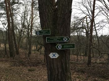
• Symbol: Blaues Kreuz (X) auf weißem Grund
![Excursión A pie Schönwald - Wanderweg Reichwalde-Kasel-Golzig-Waldow - Photo](https://media.geolcdn.com/t/350/260/213862f5-26d7-451f-b9a5-b3fd11863e6d.jpeg&format=jpg&maxdim=2)
![A pie A pie](https://static1.geolcdn.com/sitytour/trail-icons/100.png)
Km
A pie
![](/images/other/stat-length.png)
![](https://static1.geolcdn.com/siteimages/upload/files/1508320355ic_sort_den_pos_24dp.png)
![](https://static1.geolcdn.com/siteimages/upload/files/1508320355ic_sort_den_neg_24dp.png)
![](https://static1.geolcdn.com/siteimages/upload/files/16400158638029165_repeat_loop_refresh_sync_direction_icon.png)
• Symbol: horizontaler Grüner Balken
![Excursión A pie Märkische Heide - Wanderweg Pretschen-Wittmannsdorf-Bückchen-Groß Leuthen - Photo](https://media.geolcdn.com/t/350/260/a99d629f-c14a-4340-8c47-202a99e9b8b7.jpeg&format=jpg&maxdim=2)
![A pie A pie](https://static1.geolcdn.com/sitytour/trail-icons/100.png)
Km
A pie
![](/images/other/stat-length.png)
![](https://static1.geolcdn.com/siteimages/upload/files/1508320355ic_sort_den_pos_24dp.png)
![](https://static1.geolcdn.com/siteimages/upload/files/1508320355ic_sort_den_neg_24dp.png)
![](https://static1.geolcdn.com/siteimages/upload/files/16400158638029165_repeat_loop_refresh_sync_direction_icon.png)
• Symbol: gelber Balken
![Excursión A pie Halbe - Rundwanderweg Weinberg - Photo](https://media.geolcdn.com/t/350/260/fbe34954-ccee-4a24-92c7-047de1c3711b.jpeg&format=jpg&maxdim=2)
![A pie A pie](https://static1.geolcdn.com/sitytour/trail-icons/100.png)
Km
A pie
![](/images/other/stat-length.png)
![](https://static1.geolcdn.com/siteimages/upload/files/1508320355ic_sort_den_pos_24dp.png)
![](https://static1.geolcdn.com/siteimages/upload/files/1508320355ic_sort_den_neg_24dp.png)
![](https://static1.geolcdn.com/siteimages/upload/files/16400158638029165_repeat_loop_refresh_sync_direction_icon.png)
• Schlecht ausgeschildert, Verlauf teilweise erst nach mehrmaligen befahren ermittelt, lange nicht gepflegt Symbol: bl...
![Excursión A pie Halbe - Rundwanderweg Briesen-Staackmühle - Photo](https://media.geolcdn.com/t/350/260/ff0668c9-d951-4e4b-b07c-da8b426d9dd6.jpeg&format=jpg&maxdim=2)
![A pie A pie](https://static1.geolcdn.com/sitytour/trail-icons/100.png)
Km
A pie
![](/images/other/stat-length.png)
![](https://static1.geolcdn.com/siteimages/upload/files/1508320355ic_sort_den_pos_24dp.png)
![](https://static1.geolcdn.com/siteimages/upload/files/1508320355ic_sort_den_neg_24dp.png)
![](https://static1.geolcdn.com/siteimages/upload/files/16400158638029165_repeat_loop_refresh_sync_direction_icon.png)
• Schlecht ausgeschildert, Verlauf teilweise erst nach mehrmaligen befahren ermittelt, lange nicht gepflegt Symbol: gr...
![Excursión A pie Byhleguhre-Byhlen - Wanderweg Byhlen-Byhleguhre - Photo](https://media.geolcdn.com/t/350/260/47d9f170-191d-436d-bdbc-03fdd278316d.jpeg&format=jpg&maxdim=2)
![A pie A pie](https://static1.geolcdn.com/sitytour/trail-icons/100.png)
Km
A pie
![](/images/other/stat-length.png)
![](https://static1.geolcdn.com/siteimages/upload/files/1508320355ic_sort_den_pos_24dp.png)
![](https://static1.geolcdn.com/siteimages/upload/files/1508320355ic_sort_den_neg_24dp.png)
![](https://static1.geolcdn.com/siteimages/upload/files/16400158638029165_repeat_loop_refresh_sync_direction_icon.png)
• Symbol: gelber Balken auf weißem Quadrat
![Excursión A pie Spreewaldheide - Wanderweg Butzen-Byhlener See - Photo](https://media.geolcdn.com/t/350/260/0813286e-f20c-4caa-b7de-f91922cc471a.jpeg&format=jpg&maxdim=2)
![A pie A pie](https://static1.geolcdn.com/sitytour/trail-icons/100.png)
Km
A pie
![](/images/other/stat-length.png)
![](https://static1.geolcdn.com/siteimages/upload/files/1508320355ic_sort_den_pos_24dp.png)
![](https://static1.geolcdn.com/siteimages/upload/files/1508320355ic_sort_den_neg_24dp.png)
![](https://static1.geolcdn.com/siteimages/upload/files/16400158638029165_repeat_loop_refresh_sync_direction_icon.png)
• Symbol: horizontaler grüner Balken auf weißem Quadrat
![Excursión A pie Bestensee - Historischer Wanderweg Groß Besten - Photo](https://media.geolcdn.com/t/350/260/0c50e288-c358-4dfe-b25e-611b85af8c98.jpeg&format=jpg&maxdim=2)
![A pie A pie](https://static1.geolcdn.com/sitytour/trail-icons/100.png)
Km
A pie
![](/images/other/stat-length.png)
![](https://static1.geolcdn.com/siteimages/upload/files/1508320355ic_sort_den_pos_24dp.png)
![](https://static1.geolcdn.com/siteimages/upload/files/1508320355ic_sort_den_neg_24dp.png)
![](https://static1.geolcdn.com/siteimages/upload/files/16400158638029165_repeat_loop_refresh_sync_direction_icon.png)
• Trail created by Gemeinde Bestensee.
![Excursión A pie Bestensee - Wanderweg Sutschketal - Photo](https://media.geolcdn.com/t/350/260/69f0c8d6-c16a-474c-aa46-ddf7b52d5252.jpeg&format=jpg&maxdim=2)
![A pie A pie](https://static1.geolcdn.com/sitytour/trail-icons/100.png)
Km
A pie
![](/images/other/stat-length.png)
![](https://static1.geolcdn.com/siteimages/upload/files/1508320355ic_sort_den_pos_24dp.png)
![](https://static1.geolcdn.com/siteimages/upload/files/1508320355ic_sort_den_neg_24dp.png)
![](https://static1.geolcdn.com/siteimages/upload/files/16400158638029165_repeat_loop_refresh_sync_direction_icon.png)
• Trail created by Stadt Mittenwalde. Symbol: Blaues Kreuz (X) auf weißem Grund
![Excursión A pie Teupitz - Rundwanderweg Tornower See und Briesensee - Photo](https://media.geolcdn.com/t/350/260/614fe303-7971-4a39-8ca2-c09b341e4315.jpeg&format=jpg&maxdim=2)
![A pie A pie](https://static1.geolcdn.com/sitytour/trail-icons/100.png)
Km
A pie
![](/images/other/stat-length.png)
![](https://static1.geolcdn.com/siteimages/upload/files/1508320355ic_sort_den_pos_24dp.png)
![](https://static1.geolcdn.com/siteimages/upload/files/1508320355ic_sort_den_neg_24dp.png)
![](https://static1.geolcdn.com/siteimages/upload/files/16400158638029165_repeat_loop_refresh_sync_direction_icon.png)
• Trail created by Amt Schenkenländchen.
![Excursión A pie Teupitz - Schweriner Rundwanderweg - Photo](https://media.geolcdn.com/t/350/260/9d6cdfb8-1e9b-4c4e-8cf8-e5e06c9b13fe.jpeg&format=jpg&maxdim=2)
![A pie A pie](https://static1.geolcdn.com/sitytour/trail-icons/100.png)
Km
A pie
![](/images/other/stat-length.png)
![](https://static1.geolcdn.com/siteimages/upload/files/1508320355ic_sort_den_pos_24dp.png)
![](https://static1.geolcdn.com/siteimages/upload/files/1508320355ic_sort_den_neg_24dp.png)
![](https://static1.geolcdn.com/siteimages/upload/files/16400158638029165_repeat_loop_refresh_sync_direction_icon.png)
• Trail created by Amt Schenkenländchen.
![Excursión A pie Teupitz - Rundwanderweg Nikolassee - Photo](https://media.geolcdn.com/t/350/260/4658a540-d57f-4306-b0db-798416104ef6.jpeg&format=jpg&maxdim=2)
![A pie A pie](https://static1.geolcdn.com/sitytour/trail-icons/100.png)
Km
A pie
![](/images/other/stat-length.png)
![](https://static1.geolcdn.com/siteimages/upload/files/1508320355ic_sort_den_pos_24dp.png)
![](https://static1.geolcdn.com/siteimages/upload/files/1508320355ic_sort_den_neg_24dp.png)
![](https://static1.geolcdn.com/siteimages/upload/files/16400158638029165_repeat_loop_refresh_sync_direction_icon.png)
• Trail created by Amt Schenkenländchen.
![Excursión A pie Groß Köris - Lesefährte Waldweisen - Photo](https://media.geolcdn.com/t/350/260/d0f16bab-9959-4d48-bd31-26d514eb6629.jpeg&format=jpg&maxdim=2)
![A pie A pie](https://static1.geolcdn.com/sitytour/trail-icons/100.png)
Km
A pie
![](/images/other/stat-length.png)
![](https://static1.geolcdn.com/siteimages/upload/files/1508320355ic_sort_den_pos_24dp.png)
![](https://static1.geolcdn.com/siteimages/upload/files/1508320355ic_sort_den_neg_24dp.png)
![](https://static1.geolcdn.com/siteimages/upload/files/16400158638029165_repeat_loop_refresh_sync_direction_icon.png)
• Trail created by Amt Schenkenländchen.
![Excursión A pie Münchehofe - Rundwanderweg Miethsluch - Photo](https://media.geolcdn.com/t/350/260/929b4cbc-6510-4069-a8e6-ebd230814cb1.jpeg&format=jpg&maxdim=2)
![A pie A pie](https://static1.geolcdn.com/sitytour/trail-icons/100.png)
Km
A pie
![](/images/other/stat-length.png)
![](https://static1.geolcdn.com/siteimages/upload/files/1508320355ic_sort_den_pos_24dp.png)
![](https://static1.geolcdn.com/siteimages/upload/files/1508320355ic_sort_den_neg_24dp.png)
![](https://static1.geolcdn.com/siteimages/upload/files/16400158638029165_repeat_loop_refresh_sync_direction_icon.png)
• Trail created by Amt Schenkenländchen.
20 excursiones mostradas en 95
Aplicación GPS de excursión GRATIS
Actividades
Regiones próximas
- Alt Zauche-Wußwerk
- Bestensee
- Byhleguhre-Byhlen
- Groß Köris
- Halbe
- Heidesee
- Königs Wusterhausen
- Krausnick-Groß Wasserburg
- Lieberose
- Lübben (Spreewald)
- Märkisch Buchholz
- Märkische Heide
- Mittenwalde
- Münchehofe
- Neu Zauche
- Schlepzig
- Schönefeld
- Schönwald
- Schwielochsee
- Spreewaldheide
- Straupitz (Spreewald)
- Teupitz
- Unterspreewald