![](/images/other/stat-length.png)
- Excursiones
- A pie
- Germany
- Baviera
- Landkreis Aschaffenburg
- Sommerkahl
Sommerkahl, Landkreis Aschaffenburg, A pie: Los mejores itinerarios de excursión, recorridos, paseos y sendas
Sommerkahl: Descubra las mejores excursiones: 3 a pie. Todos estos circuitos, recorridos, itinerarios y actividades al aire libre están disponibles en nuestras aplicaciones SityTrail para smartphone y tablet.
Los mejores recorridos (3)
![Excursión A pie Sommerkahl - Naturlehrpfad](https://media.geolcdn.com/t/350/260/37a2dfee-d4f9-44ca-8782-d6ff34d3e978.jpeg&format=jpg&maxdim=2)
![A pie A pie](https://static1.geolcdn.com/sitytour/trail-icons/100.png)
Km
A pie
![](/images/other/stat-length.png)
![](https://static1.geolcdn.com/siteimages/upload/files/1508320355ic_sort_den_pos_24dp.png)
![](https://static1.geolcdn.com/siteimages/upload/files/1508320355ic_sort_den_neg_24dp.png)
![](https://static1.geolcdn.com/siteimages/upload/files/16400158638029165_repeat_loop_refresh_sync_direction_icon.png)
• Trail created by Naturpark Spessart. Symbol: Stilisierter Förderturm auf Hügel, weißer quadratischer Hintergrund S...
![Excursión A pie Sommerkahl - Ortswanderweg Sommerkahl 1 - Photo](https://media.geolcdn.com/t/350/260/ec6e35bf-11c3-4823-9534-4bfc333816b5.jpeg&format=jpg&maxdim=2)
![A pie A pie](https://static1.geolcdn.com/sitytour/trail-icons/100.png)
Km
A pie
![](/images/other/stat-length.png)
![](https://static1.geolcdn.com/siteimages/upload/files/1508320355ic_sort_den_pos_24dp.png)
![](https://static1.geolcdn.com/siteimages/upload/files/1508320355ic_sort_den_neg_24dp.png)
![](https://static1.geolcdn.com/siteimages/upload/files/16400158638029165_repeat_loop_refresh_sync_direction_icon.png)
• Trail created by Spessartbund. Symbol: Schwarze S1 auf weißem Grund
![Excursión A pie Sommerkahl - Kulturweg Blankenbach und Eichenberg - Photo](https://media.geolcdn.com/t/350/260/f9f477e6-d432-4b86-8987-a28bf311b929.jpeg&format=jpg&maxdim=2)
![A pie A pie](https://static1.geolcdn.com/sitytour/trail-icons/100.png)
Km
A pie
![](/images/other/stat-length.png)
![](https://static1.geolcdn.com/siteimages/upload/files/1508320355ic_sort_den_pos_24dp.png)
![](https://static1.geolcdn.com/siteimages/upload/files/1508320355ic_sort_den_neg_24dp.png)
![](https://static1.geolcdn.com/siteimages/upload/files/16400158638029165_repeat_loop_refresh_sync_direction_icon.png)
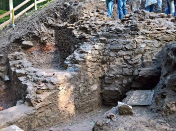
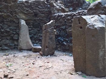
• Trail created by Archäologisches Spessartprojekt. Symbol: Gelbes EU-Schiffchen auf blauem Grund Sitio web: http://...
3 excursiones mostradas en 3
Aplicación GPS de excursión GRATIS