![](/images/other/stat-length.png)
- Excursiones
- A pie
- Switzerland
- Berna
- Verwaltungskreis Interlaken-Oberhasli
Verwaltungskreis Interlaken-Oberhasli, Berna, A pie: Los mejores itinerarios de excursión, recorridos, paseos y sendas
Verwaltungskreis Interlaken-Oberhasli: Descubra las mejores excursiones: 33 a pie, 59 senderismo, 1 carrera y 1 ruta. Todos estos circuitos, recorridos, itinerarios y actividades al aire libre están disponibles en nuestras aplicaciones SityTrail para smartphone y tablet.
Los mejores recorridos (94)
![Excursión Senderismo Innertkirchen - 2022-09-14 Marche Suisse Triftbrucke - Photo](https://media.geolcdn.com/t/350/260/3107082e-4acc-4a59-a7a2-2ee07f705959.jpg&format=jpg&maxdim=2)
![Senderismo Senderismo](https://static1.geolcdn.com/sitytour/trail-icons/101.png)
Km
Senderismo
![](/images/other/stat-length.png)
![](https://static1.geolcdn.com/siteimages/upload/files/1508320355ic_sort_den_pos_24dp.png)
![](https://static1.geolcdn.com/siteimages/upload/files/1508320355ic_sort_den_neg_24dp.png)
![](https://static1.geolcdn.com/siteimages/upload/files/16400158638029165_repeat_loop_refresh_sync_direction_icon.png)
![Excursión Senderismo Lauterbrunnen - 2022-09-13 Marche Suisse Schilthorn depuis Murren - Photo](https://media.geolcdn.com/t/350/260/0cbf3ffc-60fc-4a0b-9828-ab8f33060a72.jpg&format=jpg&maxdim=2)
![Senderismo Senderismo](https://static1.geolcdn.com/sitytour/trail-icons/101.png)
Km
Senderismo
![](/images/other/stat-length.png)
![](https://static1.geolcdn.com/siteimages/upload/files/1508320355ic_sort_den_pos_24dp.png)
![](https://static1.geolcdn.com/siteimages/upload/files/1508320355ic_sort_den_neg_24dp.png)
![](https://static1.geolcdn.com/siteimages/upload/files/16400158638029165_repeat_loop_refresh_sync_direction_icon.png)
![Excursión A pie Hasliberg - Muggestutz Zwergenweg Mägisalp - Bidmi - Photo](https://media.geolcdn.com/t/350/260/ebc7a0c9-d9fa-412e-a2b1-8364fd95473e.jpeg&format=jpg&maxdim=2)
![A pie A pie](https://static1.geolcdn.com/sitytour/trail-icons/100.png)
Km
A pie
![](/images/other/stat-length.png)
![](https://static1.geolcdn.com/siteimages/upload/files/1508320355ic_sort_den_pos_24dp.png)
![](https://static1.geolcdn.com/siteimages/upload/files/1508320355ic_sort_den_neg_24dp.png)
![](https://static1.geolcdn.com/siteimages/upload/files/16400158638029165_repeat_loop_refresh_sync_direction_icon.png)
• Sitio web: https://www.meiringen-hasliberg.ch/en/Summer/Muggestutz
![Excursión A pie Hasliberg - Kugelweg - Photo](https://media.geolcdn.com/t/350/260/ee0c39cb-35c3-495d-9cba-ea25c3f478dd.jpeg&format=jpg&maxdim=2)
![A pie A pie](https://static1.geolcdn.com/sitytour/trail-icons/100.png)
Km
A pie
![](/images/other/stat-length.png)
![](https://static1.geolcdn.com/siteimages/upload/files/1508320355ic_sort_den_pos_24dp.png)
![](https://static1.geolcdn.com/siteimages/upload/files/1508320355ic_sort_den_neg_24dp.png)
![](https://static1.geolcdn.com/siteimages/upload/files/16400158638029165_repeat_loop_refresh_sync_direction_icon.png)
• Trail created by Bergbahnen Meiringen-Hasliberg AG. Sitio web: https://www.meiringen-hasliberg.ch/de/Sommer/Wander...
![Excursión A pie Grindelwald - CH-Abzweigung Gleckstein - Glecksteinhütte - Photo](https://media.geolcdn.com/t/350/260/ef190951-62eb-4dbd-a99b-3b81e2e5a8e3.jpeg&format=jpg&maxdim=2)
![A pie A pie](https://static1.geolcdn.com/sitytour/trail-icons/100.png)
Km
A pie
![](/images/other/stat-length.png)
![](https://static1.geolcdn.com/siteimages/upload/files/1508320355ic_sort_den_pos_24dp.png)
![](https://static1.geolcdn.com/siteimages/upload/files/1508320355ic_sort_den_neg_24dp.png)
![](https://static1.geolcdn.com/siteimages/upload/files/16400158638029165_repeat_loop_refresh_sync_direction_icon.png)
• Abzweigung Gleckstein - Glecksteinhütte Symbol: weiss-rot-weiss
![Excursión A pie Grindelwald - CH-Unterlauchbühl - Bort - Photo](https://media.geolcdn.com/t/350/260/917b7bc8-fc63-4bb4-ac37-b5bc1f4152ab.jpeg&format=jpg&maxdim=2)
![A pie A pie](https://static1.geolcdn.com/sitytour/trail-icons/100.png)
Km
A pie
![](/images/other/stat-length.png)
![](https://static1.geolcdn.com/siteimages/upload/files/1508320355ic_sort_den_pos_24dp.png)
![](https://static1.geolcdn.com/siteimages/upload/files/1508320355ic_sort_den_neg_24dp.png)
![](https://static1.geolcdn.com/siteimages/upload/files/16400158638029165_repeat_loop_refresh_sync_direction_icon.png)
• Unterlauchbühl - Bort Symbol: Gelber Rhombus
![Excursión A pie Lauterbrunnen - CH-Grütschalp - Isenfluh - Photo](https://media.geolcdn.com/t/350/260/28be3b43-f3ac-42df-9f0c-340c3e14dd2e.jpeg&format=jpg&maxdim=2)
![A pie A pie](https://static1.geolcdn.com/sitytour/trail-icons/100.png)
Km
A pie
![](/images/other/stat-length.png)
![](https://static1.geolcdn.com/siteimages/upload/files/1508320355ic_sort_den_pos_24dp.png)
![](https://static1.geolcdn.com/siteimages/upload/files/1508320355ic_sort_den_neg_24dp.png)
![](https://static1.geolcdn.com/siteimages/upload/files/16400158638029165_repeat_loop_refresh_sync_direction_icon.png)
• Trail created by Berner Wanderwege. Grütschalp - Isenfluh Symbol: gelbe Raute
![Excursión A pie Lauterbrunnen - CH-Isenfluh - Alpweg - Photo](https://media.geolcdn.com/t/350/260/47546b31-1560-4321-a252-3e6f8645f75e.jpeg&format=jpg&maxdim=2)
![A pie A pie](https://static1.geolcdn.com/sitytour/trail-icons/100.png)
Km
A pie
![](/images/other/stat-length.png)
![](https://static1.geolcdn.com/siteimages/upload/files/1508320355ic_sort_den_pos_24dp.png)
![](https://static1.geolcdn.com/siteimages/upload/files/1508320355ic_sort_den_neg_24dp.png)
![](https://static1.geolcdn.com/siteimages/upload/files/16400158638029165_repeat_loop_refresh_sync_direction_icon.png)
• Trail created by Berner Wanderwege. Isenfluh - Alpweg Symbol: gelbe Raute
![Excursión A pie Lauterbrunnen - CH-Rote Härd-Sefinenfurgge - Photo](https://media.geolcdn.com/t/350/260/acb83571-17f7-45d2-825e-b2d0352cd8da.jpeg&format=jpg&maxdim=2)
![A pie A pie](https://static1.geolcdn.com/sitytour/trail-icons/100.png)
Km
A pie
![](/images/other/stat-length.png)
![](https://static1.geolcdn.com/siteimages/upload/files/1508320355ic_sort_den_pos_24dp.png)
![](https://static1.geolcdn.com/siteimages/upload/files/1508320355ic_sort_den_neg_24dp.png)
![](https://static1.geolcdn.com/siteimages/upload/files/16400158638029165_repeat_loop_refresh_sync_direction_icon.png)
• Rote Härd-Sefinenfurgge Symbol: weiss-rot-weiss
![Excursión A pie Grindelwald - First - Bachalpsee - Fauhlhorn - Schynige Platte - Photo](https://media.geolcdn.com/t/350/260/b61592a8-cb23-41ac-904f-7c76e10b8fcc.jpeg&format=jpg&maxdim=2)
![A pie A pie](https://static1.geolcdn.com/sitytour/trail-icons/100.png)
Km
A pie
![](/images/other/stat-length.png)
![](https://static1.geolcdn.com/siteimages/upload/files/1508320355ic_sort_den_pos_24dp.png)
![](https://static1.geolcdn.com/siteimages/upload/files/1508320355ic_sort_den_neg_24dp.png)
![](https://static1.geolcdn.com/siteimages/upload/files/16400158638029165_repeat_loop_refresh_sync_direction_icon.png)
• Symbol: weiss-rot-weiss
![Excursión A pie Grindelwald - Bachalpsee - Oberläger - Faulhorn - Photo](https://media.geolcdn.com/t/350/260/f62b1a84-1970-4e32-afcd-65dd14db1ded.jpeg&format=jpg&maxdim=2)
![A pie A pie](https://static1.geolcdn.com/sitytour/trail-icons/100.png)
Km
A pie
![](/images/other/stat-length.png)
![](https://static1.geolcdn.com/siteimages/upload/files/1508320355ic_sort_den_pos_24dp.png)
![](https://static1.geolcdn.com/siteimages/upload/files/1508320355ic_sort_den_neg_24dp.png)
![](https://static1.geolcdn.com/siteimages/upload/files/16400158638029165_repeat_loop_refresh_sync_direction_icon.png)
• Symbol: weiss-rot-weiss
![Excursión A pie Innertkirchen - Triftbrücke - Trifthütte - Photo](https://media.geolcdn.com/t/350/260/8bd9ff09-fe62-4e4d-9d7d-019446053c6e.jpeg&format=jpg&maxdim=2)
![A pie A pie](https://static1.geolcdn.com/sitytour/trail-icons/100.png)
Km
A pie
![](/images/other/stat-length.png)
![](https://static1.geolcdn.com/siteimages/upload/files/1508320355ic_sort_den_pos_24dp.png)
![](https://static1.geolcdn.com/siteimages/upload/files/1508320355ic_sort_den_neg_24dp.png)
![](https://static1.geolcdn.com/siteimages/upload/files/16400158638029165_repeat_loop_refresh_sync_direction_icon.png)
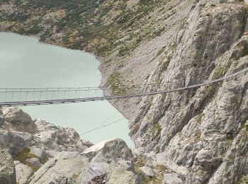
• Triftbrücke - Trifthütte
![Excursión A pie Innertkirchen - Schwendi - Underi Trift - Photo](https://media.geolcdn.com/t/350/260/547819d0-9bb2-48b2-b46c-9ac7927e831f.jpeg&format=jpg&maxdim=2)
![A pie A pie](https://static1.geolcdn.com/sitytour/trail-icons/100.png)
Km
A pie
![](/images/other/stat-length.png)
![](https://static1.geolcdn.com/siteimages/upload/files/1508320355ic_sort_den_pos_24dp.png)
![](https://static1.geolcdn.com/siteimages/upload/files/1508320355ic_sort_den_neg_24dp.png)
![](https://static1.geolcdn.com/siteimages/upload/files/16400158638029165_repeat_loop_refresh_sync_direction_icon.png)
• Schwendi - Underi Trift
![Excursión A pie Innertkirchen - Furen - Underi Trift - Photo](https://media.geolcdn.com/t/350/260/547819d0-9bb2-48b2-b46c-9ac7927e831f.jpeg&format=jpg&maxdim=2)
![A pie A pie](https://static1.geolcdn.com/sitytour/trail-icons/100.png)
Km
A pie
![](/images/other/stat-length.png)
![](https://static1.geolcdn.com/siteimages/upload/files/1508320355ic_sort_den_pos_24dp.png)
![](https://static1.geolcdn.com/siteimages/upload/files/1508320355ic_sort_den_neg_24dp.png)
![](https://static1.geolcdn.com/siteimages/upload/files/16400158638029165_repeat_loop_refresh_sync_direction_icon.png)
• Furen - Underi Trift
![Excursión A pie Innertkirchen - Alter Windeggweg - Photo](https://media.geolcdn.com/t/350/260/547819d0-9bb2-48b2-b46c-9ac7927e831f.jpeg&format=jpg&maxdim=2)
![A pie A pie](https://static1.geolcdn.com/sitytour/trail-icons/100.png)
Km
A pie
![](/images/other/stat-length.png)
![](https://static1.geolcdn.com/siteimages/upload/files/1508320355ic_sort_den_pos_24dp.png)
![](https://static1.geolcdn.com/siteimages/upload/files/1508320355ic_sort_den_neg_24dp.png)
![](https://static1.geolcdn.com/siteimages/upload/files/16400158638029165_repeat_loop_refresh_sync_direction_icon.png)
• Schwendi - Underi Trift
![Excursión A pie Habkern - Habkern - Bärenei - Photo](https://media.geolcdn.com/t/350/260/5bf8858d-0d92-4513-be83-10494bede7fc.jpeg&format=jpg&maxdim=2)
![A pie A pie](https://static1.geolcdn.com/sitytour/trail-icons/100.png)
Km
A pie
![](/images/other/stat-length.png)
![](https://static1.geolcdn.com/siteimages/upload/files/1508320355ic_sort_den_pos_24dp.png)
![](https://static1.geolcdn.com/siteimages/upload/files/1508320355ic_sort_den_neg_24dp.png)
![](https://static1.geolcdn.com/siteimages/upload/files/16400158638029165_repeat_loop_refresh_sync_direction_icon.png)
• Habkern - Bärenei Symbol: Roter Balken auf weissem Rechteck
![Excursión A pie Lauterbrunnen - Sousegg - Sattel - Photo](https://media.geolcdn.com/t/350/260/5a3fcfc2-bf24-445e-abb4-4eb6a5887c5e.jpeg&format=jpg&maxdim=2)
![A pie A pie](https://static1.geolcdn.com/sitytour/trail-icons/100.png)
Km
A pie
![](/images/other/stat-length.png)
![](https://static1.geolcdn.com/siteimages/upload/files/1508320355ic_sort_den_pos_24dp.png)
![](https://static1.geolcdn.com/siteimages/upload/files/1508320355ic_sort_den_neg_24dp.png)
![](https://static1.geolcdn.com/siteimages/upload/files/16400158638029165_repeat_loop_refresh_sync_direction_icon.png)
• Trail created by Berner Wanderwege. Sousegg - Sattel Symbol: Roter Balken auf weissem Rechteck
![Excursión A pie Grindelwald - Holewang - fixme - Photo](https://media.geolcdn.com/t/350/260/c1fd772a-1ad4-4009-8d2b-3788115972fd.jpeg&format=jpg&maxdim=2)
![A pie A pie](https://static1.geolcdn.com/sitytour/trail-icons/100.png)
Km
A pie
![](/images/other/stat-length.png)
![](https://static1.geolcdn.com/siteimages/upload/files/1508320355ic_sort_den_pos_24dp.png)
![](https://static1.geolcdn.com/siteimages/upload/files/1508320355ic_sort_den_neg_24dp.png)
![](https://static1.geolcdn.com/siteimages/upload/files/16400158638029165_repeat_loop_refresh_sync_direction_icon.png)
• Trail created by Berner Wanderwege. Holewang - fixme Symbol: gelbe Raute
![Excursión A pie Innertkirchen - Innertkirchen (KWO) - Innere Urweid - Photo](https://media.geolcdn.com/t/350/260/6a2a14a2-8383-4376-a2f9-a006a6bdf5b5.jpeg&format=jpg&maxdim=2)
![A pie A pie](https://static1.geolcdn.com/sitytour/trail-icons/100.png)
Km
A pie
![](/images/other/stat-length.png)
![](https://static1.geolcdn.com/siteimages/upload/files/1508320355ic_sort_den_pos_24dp.png)
![](https://static1.geolcdn.com/siteimages/upload/files/1508320355ic_sort_den_neg_24dp.png)
![](https://static1.geolcdn.com/siteimages/upload/files/16400158638029165_repeat_loop_refresh_sync_direction_icon.png)
• Innertkirchen (KWO) - Innere Urweid Symbol: gelber Rhombus
![Excursión A pie Grindelwald - Scheidegg / Oberläger - Wildgärst - Photo](https://media.geolcdn.com/t/350/260/4689ea70-6843-4964-b7a9-fdd50bcac679.jpeg&format=jpg&maxdim=2)
![A pie A pie](https://static1.geolcdn.com/sitytour/trail-icons/100.png)
Km
A pie
![](/images/other/stat-length.png)
![](https://static1.geolcdn.com/siteimages/upload/files/1508320355ic_sort_den_pos_24dp.png)
![](https://static1.geolcdn.com/siteimages/upload/files/1508320355ic_sort_den_neg_24dp.png)
![](https://static1.geolcdn.com/siteimages/upload/files/16400158638029165_repeat_loop_refresh_sync_direction_icon.png)
• Scheidegg / Oberläger - Wildgärst
20 excursiones mostradas en 94
Aplicación GPS de excursión GRATIS
Actividades
Regiones próximas
- Beatenberg
- Bönigen
- Brienz (BE)
- Brienzwiler
- Grindelwald
- Gsteigwiler
- Gündlischwand
- Guttannen
- Habkern
- Hasliberg
- Hofstetten bei Brienz
- Innertkirchen
- Interlaken
- Iseltwald
- Lauterbrunnen
- Leissigen
- Lütschental
- Matten bei Interlaken
- Meiringen
- Niederried bei Interlaken
- Ringgenberg (BE)
- Saxeten
- Schattenhalb
- Schwanden bei Brienz
- Unterseen
- Wilderswil