![](/images/other/stat-length.png)
- Excursiones
- A pie
- Switzerland
- Schwyz
- Einsiedeln
- Einsiedeln
Einsiedeln, Einsiedeln, A pie: Los mejores itinerarios de excursión, recorridos, paseos y sendas
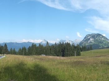
Einsiedeln: Descubra las mejores excursiones: 1 senderismo y 13 a pie. Todos estos circuitos, recorridos, itinerarios y actividades al aire libre están disponibles en nuestras aplicaciones SityTrail para smartphone y tablet.
Los mejores recorridos (14)
![Excursión A pie Einsiedeln - Einsiedler Herbschtfäscht - Photo](https://media.geolcdn.com/t/350/260/30500c4b-ebe3-41b4-985c-9c14d65545db.jpeg&format=jpg&maxdim=2)
![A pie A pie](https://static1.geolcdn.com/sitytour/trail-icons/100.png)
Km
A pie
![](/images/other/stat-length.png)
![](https://static1.geolcdn.com/siteimages/upload/files/1508320355ic_sort_den_pos_24dp.png)
![](https://static1.geolcdn.com/siteimages/upload/files/1508320355ic_sort_den_neg_24dp.png)
![](https://static1.geolcdn.com/siteimages/upload/files/16400158638029165_repeat_loop_refresh_sync_direction_icon.png)
• Sitio web: http://www.herbscht-faescht.ch
![Excursión A pie Einsiedeln - Wildegg - Vorderthal - Photo](https://media.geolcdn.com/t/350/260/81ce2736-4d80-4cc5-8c00-c81a67834328.jpeg&format=jpg&maxdim=2)
![A pie A pie](https://static1.geolcdn.com/sitytour/trail-icons/100.png)
Km
A pie
![](/images/other/stat-length.png)
![](https://static1.geolcdn.com/siteimages/upload/files/1508320355ic_sort_den_pos_24dp.png)
![](https://static1.geolcdn.com/siteimages/upload/files/1508320355ic_sort_den_neg_24dp.png)
![](https://static1.geolcdn.com/siteimages/upload/files/16400158638029165_repeat_loop_refresh_sync_direction_icon.png)
• Trail created by Umweltdepartement Kt Schwyz. Symbol: weiss-rot-weiss
![Excursión A pie Einsiedeln - Panoramaweg Sihlsee - Photo](https://media.geolcdn.com/t/350/260/7b3b5159-376c-4f89-8890-ac7901fe9713.jpeg&format=jpg&maxdim=2)
![A pie A pie](https://static1.geolcdn.com/sitytour/trail-icons/100.png)
Km
A pie
![](/images/other/stat-length.png)
![](https://static1.geolcdn.com/siteimages/upload/files/1508320355ic_sort_den_pos_24dp.png)
![](https://static1.geolcdn.com/siteimages/upload/files/1508320355ic_sort_den_neg_24dp.png)
![](https://static1.geolcdn.com/siteimages/upload/files/16400158638029165_repeat_loop_refresh_sync_direction_icon.png)
• Trail created by Einsiedeln Tourismus.
![Excursión A pie Einsiedeln - Ruestel - Chrähwäldli - Photo](https://media.geolcdn.com/t/350/260/3aef4441-25a0-4960-9d95-36507d1b810a.jpeg&format=jpg&maxdim=2)
![A pie A pie](https://static1.geolcdn.com/sitytour/trail-icons/100.png)
Km
A pie
![](/images/other/stat-length.png)
![](https://static1.geolcdn.com/siteimages/upload/files/1508320355ic_sort_den_pos_24dp.png)
![](https://static1.geolcdn.com/siteimages/upload/files/1508320355ic_sort_den_neg_24dp.png)
![](https://static1.geolcdn.com/siteimages/upload/files/16400158638029165_repeat_loop_refresh_sync_direction_icon.png)
• Trail created by Umweltdepartement Kt Schwyz. Ruestel - Chrähwäldli Symbol: rot weiss rot
![Excursión A pie Einsiedeln - Euthal - Heitligeer - Photo](https://media.geolcdn.com/t/350/260/0b8b90e4-4d41-4458-b5a5-54e5a0712d7f.jpeg&format=jpg&maxdim=2)
![A pie A pie](https://static1.geolcdn.com/sitytour/trail-icons/100.png)
Km
A pie
![](/images/other/stat-length.png)
![](https://static1.geolcdn.com/siteimages/upload/files/1508320355ic_sort_den_pos_24dp.png)
![](https://static1.geolcdn.com/siteimages/upload/files/1508320355ic_sort_den_neg_24dp.png)
![](https://static1.geolcdn.com/siteimages/upload/files/16400158638029165_repeat_loop_refresh_sync_direction_icon.png)
• Trail created by Umweltdepartement Kt Schwyz. Euthal - Heitligeer Symbol: gelber Diamant
![Excursión A pie Einsiedeln - Euthal - vord. Chrumfluh - Photo](https://media.geolcdn.com/t/350/260/0b8b90e4-4d41-4458-b5a5-54e5a0712d7f.jpeg&format=jpg&maxdim=2)
![A pie A pie](https://static1.geolcdn.com/sitytour/trail-icons/100.png)
Km
A pie
![](/images/other/stat-length.png)
![](https://static1.geolcdn.com/siteimages/upload/files/1508320355ic_sort_den_pos_24dp.png)
![](https://static1.geolcdn.com/siteimages/upload/files/1508320355ic_sort_den_neg_24dp.png)
![](https://static1.geolcdn.com/siteimages/upload/files/16400158638029165_repeat_loop_refresh_sync_direction_icon.png)
• Trail created by Umweltdepartement Kt Schwyz. Euthal - vord. Chrumfluh Symbol: rot weiss rot
![Excursión A pie Einsiedeln - Einsiedeln Bahnhof - Schwyzeren - Photo](https://media.geolcdn.com/t/350/260/e9e48be6-d67b-45b2-a2be-807c673d44cb.jpeg&format=jpg&maxdim=2)
![A pie A pie](https://static1.geolcdn.com/sitytour/trail-icons/100.png)
Km
A pie
![](/images/other/stat-length.png)
![](https://static1.geolcdn.com/siteimages/upload/files/1508320355ic_sort_den_pos_24dp.png)
![](https://static1.geolcdn.com/siteimages/upload/files/1508320355ic_sort_den_neg_24dp.png)
![](https://static1.geolcdn.com/siteimages/upload/files/16400158638029165_repeat_loop_refresh_sync_direction_icon.png)
• Trail created by Umweltdepartement Kt Schwyz. Einsiedeln Bahnhof - Schwyzeren Symbol: gelber Diamant
![Excursión A pie Einsiedeln - Egg - Büel - Photo](https://media.geolcdn.com/t/350/260/5fd4ef73-33a4-48f8-a156-ebf9170db81e.jpeg&format=jpg&maxdim=2)
![A pie A pie](https://static1.geolcdn.com/sitytour/trail-icons/100.png)
Km
A pie
![](/images/other/stat-length.png)
![](https://static1.geolcdn.com/siteimages/upload/files/1508320355ic_sort_den_pos_24dp.png)
![](https://static1.geolcdn.com/siteimages/upload/files/1508320355ic_sort_den_neg_24dp.png)
![](https://static1.geolcdn.com/siteimages/upload/files/16400158638029165_repeat_loop_refresh_sync_direction_icon.png)
• Trail created by Umweltdepartement Kt Schwyz. Egg - Büel Symbol: gelber Diamant
![Excursión A pie Einsiedeln - Lehpfad Klosterwald - Photo](https://media.geolcdn.com/t/350/260/738abf46-c6bd-462c-bbd4-e9a3cf6a199d.jpeg&format=jpg&maxdim=2)
![A pie A pie](https://static1.geolcdn.com/sitytour/trail-icons/100.png)
Km
A pie
![](/images/other/stat-length.png)
![](https://static1.geolcdn.com/siteimages/upload/files/1508320355ic_sort_den_pos_24dp.png)
![](https://static1.geolcdn.com/siteimages/upload/files/1508320355ic_sort_den_neg_24dp.png)
![](https://static1.geolcdn.com/siteimages/upload/files/16400158638029165_repeat_loop_refresh_sync_direction_icon.png)
![Excursión A pie Einsiedeln - Trachslau - Alpthal - Photo](https://media.geolcdn.com/t/350/260/662a0d8b-44d1-4a5d-ab80-a7df99768635.jpeg&format=jpg&maxdim=2)
![A pie A pie](https://static1.geolcdn.com/sitytour/trail-icons/100.png)
Km
A pie
![](/images/other/stat-length.png)
![](https://static1.geolcdn.com/siteimages/upload/files/1508320355ic_sort_den_pos_24dp.png)
![](https://static1.geolcdn.com/siteimages/upload/files/1508320355ic_sort_den_neg_24dp.png)
![](https://static1.geolcdn.com/siteimages/upload/files/16400158638029165_repeat_loop_refresh_sync_direction_icon.png)
• Trail created by Umweltdepartement Kt Schwyz. Symbol: gelber Diamant
![Excursión A pie Einsiedeln - Geissweidli - Egg - Photo](https://media.geolcdn.com/t/350/260/a2f3e4b7-cbb3-4115-a261-aa318e3e1f3b.jpeg&format=jpg&maxdim=2)
![A pie A pie](https://static1.geolcdn.com/sitytour/trail-icons/100.png)
Km
A pie
![](/images/other/stat-length.png)
![](https://static1.geolcdn.com/siteimages/upload/files/1508320355ic_sort_den_pos_24dp.png)
![](https://static1.geolcdn.com/siteimages/upload/files/1508320355ic_sort_den_neg_24dp.png)
![](https://static1.geolcdn.com/siteimages/upload/files/16400158638029165_repeat_loop_refresh_sync_direction_icon.png)
• Trail created by Umweltdepartement Kt Schwyz. Geissweidli - Egg Symbol: gelber Diamant
![Excursión A pie Einsiedeln - Geissweidli - Sattelegg - Photo](https://media.geolcdn.com/t/350/260/50b7cdca-17fc-41c0-bec5-9f59f0b498fd.jpeg&format=jpg&maxdim=2)
![A pie A pie](https://static1.geolcdn.com/sitytour/trail-icons/100.png)
Km
A pie
![](/images/other/stat-length.png)
![](https://static1.geolcdn.com/siteimages/upload/files/1508320355ic_sort_den_pos_24dp.png)
![](https://static1.geolcdn.com/siteimages/upload/files/1508320355ic_sort_den_neg_24dp.png)
![](https://static1.geolcdn.com/siteimages/upload/files/16400158638029165_repeat_loop_refresh_sync_direction_icon.png)
• Trail created by Umweltdepartement Kt Schwyz. Geissweidli - Sattelegg Symbol: gelber Diamant
![Excursión A pie Einsiedeln - Rinderweidhorn - Gueteregg - Photo](https://media.geolcdn.com/t/350/260/174efb65-4b47-42b8-88c7-518a37d473b9.jpeg&format=jpg&maxdim=2)
![A pie A pie](https://static1.geolcdn.com/sitytour/trail-icons/100.png)
Km
A pie
![](/images/other/stat-length.png)
![](https://static1.geolcdn.com/siteimages/upload/files/1508320355ic_sort_den_pos_24dp.png)
![](https://static1.geolcdn.com/siteimages/upload/files/1508320355ic_sort_den_neg_24dp.png)
![](https://static1.geolcdn.com/siteimages/upload/files/16400158638029165_repeat_loop_refresh_sync_direction_icon.png)
• Trail created by Umweltdepartement Kt Schwyz. Rinderweidhorn - Gueteregg Symbol: gelber Diamant
![Excursión Senderismo Einsiedeln - sf10_e4a - Photo](https://media.geolcdn.com/t/350/260/ext.jpg?maxdim=2&url=https%3A%2F%2Fstatic1.geolcdn.com%2Fsiteimages%2Fupload%2Ffiles%2F1553511878bg_sport_marche.png)
![Senderismo Senderismo](https://static1.geolcdn.com/sitytour/trail-icons/101.png)
Km
Senderismo
![](/images/other/stat-length.png)
![](https://static1.geolcdn.com/siteimages/upload/files/1508320355ic_sort_den_pos_24dp.png)
![](https://static1.geolcdn.com/siteimages/upload/files/1508320355ic_sort_den_neg_24dp.png)
![](https://static1.geolcdn.com/siteimages/upload/files/16400158638029165_repeat_loop_refresh_sync_direction_icon.png)
•
14 excursiones mostradas en 14
Aplicación GPS de excursión GRATIS