![](/images/other/stat-length.png)
- Excursiones
- A pie
- Austria
- Tirol
Tirol, Austria, A pie: Los mejores itinerarios de excursión, recorridos, paseos y sendas
Tirol: Descubra las mejores excursiones: 235 a pie, 230 senderismo, 1 marcha nórdica y 6 ruta. Todos estos circuitos, recorridos, itinerarios y actividades al aire libre están disponibles en nuestras aplicaciones SityTrail para smartphone y tablet.
Los mejores recorridos (472)
![Excursión Senderismo Gemeinde Umhausen - La cascade de Stuibenfall - Photo](https://media.geolcdn.com/t/350/260/ext.jpg?maxdim=2&url=https%3A%2F%2Fservices.sitytrail.com%2FGeolivesWS%2FDownloadMedia.ashx%3FTrailID%3D617406%26Media%3Dfix__20160727135320.jpg)
![Senderismo Senderismo](https://static1.geolcdn.com/sitytour/trail-icons/101.png)
Km
Senderismo
![](/images/other/stat-length.png)
![](https://static1.geolcdn.com/siteimages/upload/files/1508320355ic_sort_den_pos_24dp.png)
![](https://static1.geolcdn.com/siteimages/upload/files/1508320355ic_sort_den_neg_24dp.png)
![](https://static1.geolcdn.com/siteimages/upload/files/16400158638029165_repeat_loop_refresh_sync_direction_icon.png)
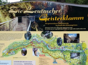
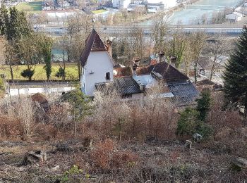
• Faite le 27/07/2016 avec notre fils de 11 ans. La cascade de Stuibenfall est située à Umhausen dans la vallée d'Ötzta...
![Excursión Senderismo Gemeinde Seefeld in Tirol - Les hauteurs de Seefeld - Photo](https://media.geolcdn.com/t/350/260/ext.jpg?maxdim=2&url=https%3A%2F%2Fservices.sitytrail.com%2FGeolivesWS%2FDownloadMedia.ashx%3FTrailID%3D608758%26Media%3Dfix__20160730095135.jpg)
![Senderismo Senderismo](https://static1.geolcdn.com/sitytour/trail-icons/101.png)
Km
Senderismo
![](/images/other/stat-length.png)
![](https://static1.geolcdn.com/siteimages/upload/files/1508320355ic_sort_den_pos_24dp.png)
![](https://static1.geolcdn.com/siteimages/upload/files/1508320355ic_sort_den_neg_24dp.png)
![](https://static1.geolcdn.com/siteimages/upload/files/16400158638029165_repeat_loop_refresh_sync_direction_icon.png)
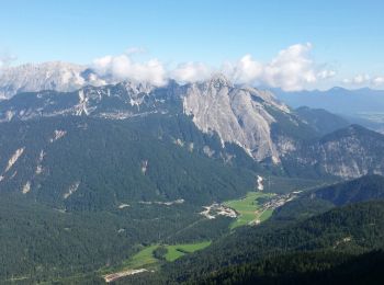
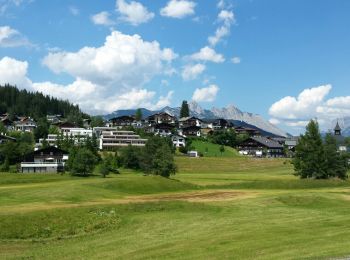
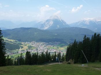
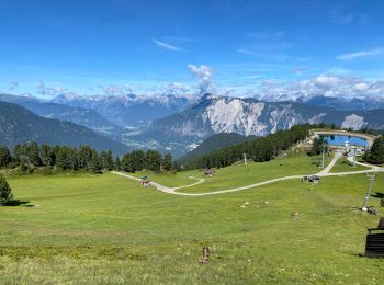
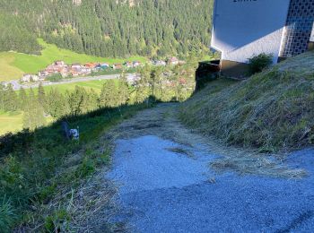
• Faite le 30/07/2016 avec notre fils de 11 ans. Montée avec le funiculaire jusqu'à la Rosshütte puis le téléphérique j...
![Excursión Senderismo Gemeinde Leutasch - Leutascher Geistelklamm - Photo](https://media.geolcdn.com/t/350/260/ext.jpg?maxdim=2&url=https%3A%2F%2Fservices.sitytrail.com%2FGeolivesWS%2FDownloadMedia.ashx%3FTrailID%3D450001%26Media%3Dfix__20150723133419.jpg)
![Senderismo Senderismo](https://static1.geolcdn.com/sitytour/trail-icons/101.png)
Km
Senderismo
![](/images/other/stat-length.png)
![](https://static1.geolcdn.com/siteimages/upload/files/1508320355ic_sort_den_pos_24dp.png)
![](https://static1.geolcdn.com/siteimages/upload/files/1508320355ic_sort_den_neg_24dp.png)
![](https://static1.geolcdn.com/siteimages/upload/files/16400158638029165_repeat_loop_refresh_sync_direction_icon.png)
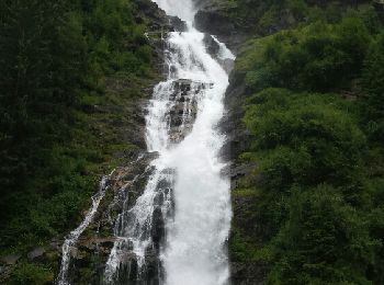
• Faite le 23/07/2015 avec notre fils de 10 ans.
![Excursión Senderismo Gemeinde Seefeld in Tirol - Seefelder Spitze et pied de la Reither Spitze - Photo](https://media.geolcdn.com/t/350/260/ext.jpg?maxdim=2&url=https%3A%2F%2Fservices.sitytrail.com%2FGeolivesWS%2FDownloadMedia.ashx%3FTrailID%3D449997%26Media%3Dfix__20150722134415.jpg)
![Senderismo Senderismo](https://static1.geolcdn.com/sitytour/trail-icons/101.png)
Km
Senderismo
![](/images/other/stat-length.png)
![](https://static1.geolcdn.com/siteimages/upload/files/1508320355ic_sort_den_pos_24dp.png)
![](https://static1.geolcdn.com/siteimages/upload/files/1508320355ic_sort_den_neg_24dp.png)
![](https://static1.geolcdn.com/siteimages/upload/files/16400158638029165_repeat_loop_refresh_sync_direction_icon.png)
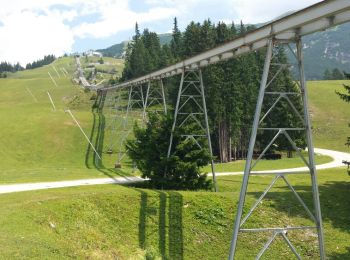
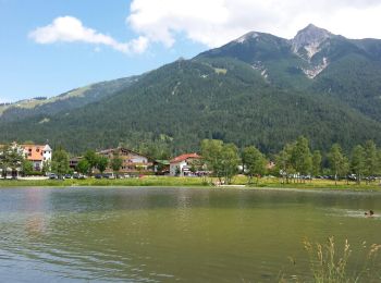
• Faite le 22/07/2015 avec notre fils de 10 ans. Montée avec le funiculaire jusqu'à la Rosshütte puis le téléphérique j...
![Excursión Senderismo Gemeinde Seefeld in Tirol - Les lacs - Wildmoos - Möserersee - Photo](https://media.geolcdn.com/t/350/260/ext.jpg?maxdim=2&url=https%3A%2F%2Fservices.sitytrail.com%2FGeolivesWS%2FDownloadMedia.ashx%3FTrailID%3D449996%26Media%3Dfix__20150721150101.jpg)
![Senderismo Senderismo](https://static1.geolcdn.com/sitytour/trail-icons/101.png)
Km
Senderismo
![](/images/other/stat-length.png)
![](https://static1.geolcdn.com/siteimages/upload/files/1508320355ic_sort_den_pos_24dp.png)
![](https://static1.geolcdn.com/siteimages/upload/files/1508320355ic_sort_den_neg_24dp.png)
![](https://static1.geolcdn.com/siteimages/upload/files/16400158638029165_repeat_loop_refresh_sync_direction_icon.png)
• Faite le 21/07/2015 avec notre fils de 10 ans. Randonnée guidée gratuite proposée par Sport Aktiv et les hotels de Se...
![Excursión Senderismo Gemeinde Seefeld in Tirol - Mösern - Gschwandtkopf - Reith - Photo](https://media.geolcdn.com/t/350/260/ext.jpg?maxdim=2&url=https%3A%2F%2Fservices.sitytrail.com%2FGeolivesWS%2FDownloadMedia.ashx%3FTrailID%3D449994%26Media%3Dfix__20150720142243.jpg)
![Senderismo Senderismo](https://static1.geolcdn.com/sitytour/trail-icons/101.png)
Km
Senderismo
![](/images/other/stat-length.png)
![](https://static1.geolcdn.com/siteimages/upload/files/1508320355ic_sort_den_pos_24dp.png)
![](https://static1.geolcdn.com/siteimages/upload/files/1508320355ic_sort_den_neg_24dp.png)
![](https://static1.geolcdn.com/siteimages/upload/files/16400158638029165_repeat_loop_refresh_sync_direction_icon.png)
• Faite le 20/07/2015 avec notre fils de 10 ans. Randonnée guidée gratuite proposée par Sport Aktiv et les Hotels de Se...
![Excursión Senderismo Gemeinde Seefeld in Tirol - Seefelder Spitze - Photo](https://media.geolcdn.com/t/350/260/ext.jpg?maxdim=2&url=https%3A%2F%2Fservices.sitytrail.com%2FGeolivesWS%2FDownloadMedia.ashx%3FTrailID%3D449993%26Media%3Dfix__20150719120459.jpg)
![Senderismo Senderismo](https://static1.geolcdn.com/sitytour/trail-icons/101.png)
Km
Senderismo
![](/images/other/stat-length.png)
![](https://static1.geolcdn.com/siteimages/upload/files/1508320355ic_sort_den_pos_24dp.png)
![](https://static1.geolcdn.com/siteimages/upload/files/1508320355ic_sort_den_neg_24dp.png)
![](https://static1.geolcdn.com/siteimages/upload/files/16400158638029165_repeat_loop_refresh_sync_direction_icon.png)
• Faite le 19/07/2015 avec notre fils de 10 ans. Montée avec le funiculaire jusqu'à la Rosshütte puis le téléphérique j...
![Excursión Senderismo Gemeinde Oetz - Oetzel sommets - Photo](https://media.geolcdn.com/t/350/260/fcb3df68-02c5-400f-8834-648baace6aab.jpg&format=jpg&maxdim=2)
![Senderismo Senderismo](https://static1.geolcdn.com/sitytour/trail-icons/101.png)
Km
Senderismo
![](/images/other/stat-length.png)
![](https://static1.geolcdn.com/siteimages/upload/files/1508320355ic_sort_den_pos_24dp.png)
![](https://static1.geolcdn.com/siteimages/upload/files/1508320355ic_sort_den_neg_24dp.png)
![](https://static1.geolcdn.com/siteimages/upload/files/16400158638029165_repeat_loop_refresh_sync_direction_icon.png)
![Excursión Senderismo Gemeinde Sölden - Solden perlesee 14 Km - Photo](https://media.geolcdn.com/t/350/260/302e7b93-e744-42bf-a021-d29e1a9c902f.jpg&format=jpg&maxdim=2)
![Senderismo Senderismo](https://static1.geolcdn.com/sitytour/trail-icons/101.png)
Km
Senderismo
![](/images/other/stat-length.png)
![](https://static1.geolcdn.com/siteimages/upload/files/1508320355ic_sort_den_pos_24dp.png)
![](https://static1.geolcdn.com/siteimages/upload/files/1508320355ic_sort_den_neg_24dp.png)
![](https://static1.geolcdn.com/siteimages/upload/files/16400158638029165_repeat_loop_refresh_sync_direction_icon.png)
![Excursión A pie Stadt Kufstein - Prinz Luitpold Weg - Photo](https://media.geolcdn.com/t/350/260/7aaf1793-4671-43af-9ad0-5e7767904bdf.jpeg&format=jpg&maxdim=2)
![A pie A pie](https://static1.geolcdn.com/sitytour/trail-icons/100.png)
Km
A pie
![](/images/other/stat-length.png)
![](https://static1.geolcdn.com/siteimages/upload/files/1508320355ic_sort_den_pos_24dp.png)
![](https://static1.geolcdn.com/siteimages/upload/files/1508320355ic_sort_den_neg_24dp.png)
![](https://static1.geolcdn.com/siteimages/upload/files/16400158638029165_repeat_loop_refresh_sync_direction_icon.png)
• Trail created by IVV. Symbol: Hellblaue Rechtecke mit Ordenssilhouette und der Aufschrift "Kaiser Max Weg"
![Excursión A pie Stadt Kufstein - Kapellenweg - Photo](https://media.geolcdn.com/t/350/260/e7b6607e-c32c-4d8c-b4a0-d43dc902835a.jpeg&format=jpg&maxdim=2)
![A pie A pie](https://static1.geolcdn.com/sitytour/trail-icons/100.png)
Km
A pie
![](/images/other/stat-length.png)
![](https://static1.geolcdn.com/siteimages/upload/files/1508320355ic_sort_den_pos_24dp.png)
![](https://static1.geolcdn.com/siteimages/upload/files/1508320355ic_sort_den_neg_24dp.png)
![](https://static1.geolcdn.com/siteimages/upload/files/16400158638029165_repeat_loop_refresh_sync_direction_icon.png)
• Trail created by IVV. Symbol: Violette Rechtecke mit Heiligensilhouette und der Aufschrift "Kapellenweg"
![Excursión A pie Stadt Kufstein - Denkmalwanderung - Photo](https://media.geolcdn.com/t/350/260/050b7c40-79f2-444c-adf3-bc878881d4c9.jpeg&format=jpg&maxdim=2)
![A pie A pie](https://static1.geolcdn.com/sitytour/trail-icons/100.png)
Km
A pie
![](/images/other/stat-length.png)
![](https://static1.geolcdn.com/siteimages/upload/files/1508320355ic_sort_den_pos_24dp.png)
![](https://static1.geolcdn.com/siteimages/upload/files/1508320355ic_sort_den_neg_24dp.png)
![](https://static1.geolcdn.com/siteimages/upload/files/16400158638029165_repeat_loop_refresh_sync_direction_icon.png)
• Trail created by IVV. Symbol: Dunkelgraue Rechtecke mit Oberkörpersilhouette und der Aufschrift "Denkmalwanderung"
![Excursión A pie Stadt Kufstein - Energieweg Kufstein - Photo](https://media.geolcdn.com/t/350/260/768c9069-4cc0-4c9d-965e-70eff8e8e6d4.jpeg&format=jpg&maxdim=2)
![A pie A pie](https://static1.geolcdn.com/sitytour/trail-icons/100.png)
Km
A pie
![](/images/other/stat-length.png)
![](https://static1.geolcdn.com/siteimages/upload/files/1508320355ic_sort_den_pos_24dp.png)
![](https://static1.geolcdn.com/siteimages/upload/files/1508320355ic_sort_den_neg_24dp.png)
![](https://static1.geolcdn.com/siteimages/upload/files/16400158638029165_repeat_loop_refresh_sync_direction_icon.png)
• Symbol: Braune Rechtecke mit Kreissymbol und der Aufschrift "Energieweg Kufstein"
![Excursión A pie Stadt Kufstein - Rund um Kufstein - Photo](https://media.geolcdn.com/t/350/260/e1bd58f2-db1d-4ff1-908f-b08c89061459.jpeg&format=jpg&maxdim=2)
![A pie A pie](https://static1.geolcdn.com/sitytour/trail-icons/100.png)
Km
A pie
![](/images/other/stat-length.png)
![](https://static1.geolcdn.com/siteimages/upload/files/1508320355ic_sort_den_pos_24dp.png)
![](https://static1.geolcdn.com/siteimages/upload/files/1508320355ic_sort_den_neg_24dp.png)
![](https://static1.geolcdn.com/siteimages/upload/files/16400158638029165_repeat_loop_refresh_sync_direction_icon.png)
• Trail created by IVV. Symbol: Olive Rechtecke mit Stadtsilhouette und der Aufschrift "Rund um Kufstein"
![Excursión A pie Stadt Kufstein - Elfenhain-Trail - Photo](https://media.geolcdn.com/t/350/260/bf877ae3-7b85-40db-872a-fc43df081ae7.jpeg&format=jpg&maxdim=2)
![A pie A pie](https://static1.geolcdn.com/sitytour/trail-icons/100.png)
Km
A pie
![](/images/other/stat-length.png)
![](https://static1.geolcdn.com/siteimages/upload/files/1508320355ic_sort_den_pos_24dp.png)
![](https://static1.geolcdn.com/siteimages/upload/files/1508320355ic_sort_den_neg_24dp.png)
![](https://static1.geolcdn.com/siteimages/upload/files/16400158638029165_repeat_loop_refresh_sync_direction_icon.png)
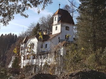
• Trail created by Kufsteinerland. Symbol: Weiße Schilder mit Richtungspfeil und rotem Streifen mit dem Namen "Elfenha...
![Excursión A pie Gemeinde Ebbs - Inn Rundweg - Photo](https://media.geolcdn.com/t/350/260/daaecc59-bccf-4b5e-b34b-e9247f0a0214.jpeg&format=jpg&maxdim=2)
![A pie A pie](https://static1.geolcdn.com/sitytour/trail-icons/100.png)
Km
A pie
![](/images/other/stat-length.png)
![](https://static1.geolcdn.com/siteimages/upload/files/1508320355ic_sort_den_pos_24dp.png)
![](https://static1.geolcdn.com/siteimages/upload/files/1508320355ic_sort_den_neg_24dp.png)
![](https://static1.geolcdn.com/siteimages/upload/files/16400158638029165_repeat_loop_refresh_sync_direction_icon.png)
• Symbol: Türkise Rechtecke mit Wellensymbol und der Aufschrift "Inn Rundweg"
![Excursión A pie Stadt Kufstein - Brentenjoch-Trail - Photo](https://media.geolcdn.com/t/350/260/1c6a7877-1f15-44ce-859e-d53183c65a67.jpeg&format=jpg&maxdim=2)
![A pie A pie](https://static1.geolcdn.com/sitytour/trail-icons/100.png)
Km
A pie
![](/images/other/stat-length.png)
![](https://static1.geolcdn.com/siteimages/upload/files/1508320355ic_sort_den_pos_24dp.png)
![](https://static1.geolcdn.com/siteimages/upload/files/1508320355ic_sort_den_neg_24dp.png)
![](https://static1.geolcdn.com/siteimages/upload/files/16400158638029165_repeat_loop_refresh_sync_direction_icon.png)
• Trail created by Kufsteinerland. Symbol: Weiße Schilder mit Richtungspfeil und blauem Streifen mit dem Namen "Brente...
![Excursión A pie Gemeinde Erl - Euregio Marien-Wege - Photo](https://media.geolcdn.com/t/350/260/797c713e-12d0-48f6-8c0e-6e9af5a814a9.jpeg&format=jpg&maxdim=2)
![A pie A pie](https://static1.geolcdn.com/sitytour/trail-icons/100.png)
Km
A pie
![](/images/other/stat-length.png)
![](https://static1.geolcdn.com/siteimages/upload/files/1508320355ic_sort_den_pos_24dp.png)
![](https://static1.geolcdn.com/siteimages/upload/files/1508320355ic_sort_den_neg_24dp.png)
![](https://static1.geolcdn.com/siteimages/upload/files/16400158638029165_repeat_loop_refresh_sync_direction_icon.png)
• Symbol: Weiße Rechtecke mit Farbpunkten und der Aufschrift "EUREGIO Marien-Wege"
![Excursión A pie Gemeinde Ebbs - St. Nikolaus Rundweg - Photo](https://media.geolcdn.com/t/350/260/3503f523-6992-40ce-bbac-ceb7704c0996.jpeg&format=jpg&maxdim=2)
![A pie A pie](https://static1.geolcdn.com/sitytour/trail-icons/100.png)
Km
A pie
![](/images/other/stat-length.png)
![](https://static1.geolcdn.com/siteimages/upload/files/1508320355ic_sort_den_pos_24dp.png)
![](https://static1.geolcdn.com/siteimages/upload/files/1508320355ic_sort_den_neg_24dp.png)
![](https://static1.geolcdn.com/siteimages/upload/files/16400158638029165_repeat_loop_refresh_sync_direction_icon.png)
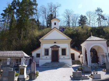
• Symbol: Violette Rechtecke mit Kirchensymbol und der Aufschrift "St. Nikolaus Rundweg"
![Excursión A pie Gemeinde Ebbs - Haflinger Rundweg - Photo](https://media.geolcdn.com/t/350/260/c486675e-7789-4fa8-85da-a10fdec7f7ad.jpeg&format=jpg&maxdim=2)
![A pie A pie](https://static1.geolcdn.com/sitytour/trail-icons/100.png)
Km
A pie
![](/images/other/stat-length.png)
![](https://static1.geolcdn.com/siteimages/upload/files/1508320355ic_sort_den_pos_24dp.png)
![](https://static1.geolcdn.com/siteimages/upload/files/1508320355ic_sort_den_neg_24dp.png)
![](https://static1.geolcdn.com/siteimages/upload/files/16400158638029165_repeat_loop_refresh_sync_direction_icon.png)
• Trail created by Gemeinde Ebbs. Symbol: Braune Rechtecke mit Pferdekopf und der Aufschrift "Haflinger Rundweg"
20 excursiones mostradas en 472
Aplicación GPS de excursión GRATIS