


4,1 km | 6 km-effort
Desconocido: Descubra las mejores excursiones: 31 a pie y 13 senderismo. Todos estos circuitos, recorridos, itinerarios y actividades al aire libre están disponibles en nuestras aplicaciones SityTrail para smartphone y tablet.
A pie


• Trail created by Naturfreunde.
A pie
• Trail created by Österreichischer Astronomischer Verein.
A pie
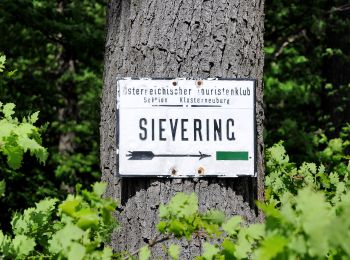
• Trail created by ÖTK-Klosterneuburg. Symbol: weiss-blau-weiss
A pie
• Trail created by ÖTK-Klosterneuburg; Freunde des Kahlenbergerdorfes. another website: http://www.kahlenbergerdorf.at...
A pie
• Trail created by ÖTK-Klosterneuburg. Symbol: weiss-blau-weiss Sitio web: https://www.oetk-klosterneuburg.at/index....
A pie
• Trail created by ÖTK-Klosterneuburg. Symbol: weiss-gruen-weiss Sitio web: https://www.oetk-klosterneuburg.at/index...
A pie
• Trail created by ÖTK-Klosterneuburg. Symbol: weiss-rot-weiss Sitio web: https://www.oetk-klosterneuburg.at/index.p...
A pie
• Trail created by ÖTK-Klosterneuburg. Symbol: weiss-blau-weiss Sitio web: https://www.oetk-klosterneuburg.at/index....
A pie
• Trail created by ÖTK-Klosterneuburg. Symbol: weiss-gruen-weiss Sitio web: https://www.oetk-klosterneuburg.at/index...
A pie
• Trail created by ÖTK-Klosterneuburg. Symbol: weiss-blau-weiss Sitio web: https://www.oetk-klosterneuburg.at/index....
A pie
• Trail created by ÖTK-Klosterneuburg. Symbol: weiss-blau-weiss Sitio web: https://www.oetk-klosterneuburg.at/index....
A pie
• Symbol: ohne Markierung
A pie
• Trail created by Österreichischer Touristenklub. Symbol: grüner, waagrechter Balken

A pie
• Trail created by Stadt Wien (Forstamt). http://wiki.openstreetmap.org/index.php?title=WikiProject_Austria/Wanderwege
A pie
• Trail created by Stadt Wien (Forstamt). http://wiki.openstreetmap.org/index.php?title=WikiProject_Austria/Wanderwege

A pie
• Trail created by Stadt Wien (Forstamt). http://wiki.openstreetmap.org/index.php?title=WikiProject_Austria/Wanderwege
A pie
• Trail created by Stadt Wien (Forstamt). http://wiki.openstreetmap.org/index.php?title=WikiProject_Austria/Wanderwege
A pie
• osmc:symbol geändert damit auf Karte sichbar, vorher pink:white:pink_bar Symbol: weiß pink
A pie
• osmc:symbol geändert damit auf Karte sichbar, vorher pink:white:pink_bar Symbol: weiß pink
A pie
• Trail created by Stadt Wien (Forstamt). http://wiki.openstreetmap.org/index.php?title=WikiProject_Austria/Wanderwege...
20 excursiones mostradas en 44
Aplicación GPS de excursión GRATIS
 SityTrail
IGN / Institutos geográficos
SityTrail World
El mundo es suyo