


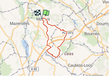

11.6 km | 14.1 km-effort

User GUIDE


FREE GPS app for hiking
 SityTrail
IGN / Geographical institutes
SityTrail World
The world is yours!
Trail Nordic walking of 11.6 km to be discovered at New Aquitaine, Pyrénées-Atlantiques, Momas. This trail is proposed by marmotte65.
Vu l'humidité présente sur le terrain prévoir minimum 15 jours sans pluie avant de pouvoir pratiquer correctement ces sentiers
 "
data-pinterest-text="Pin it"
data-tweet-text="share on twitter"
data-facebook-share-url="https://www.sitytrail.com/en/trails/3972141-momas--momas-reco-chemin-de-l-aubiosse-x3972141x/?photo=1#lg=1&slide=1"
data-twitter-share-url="https://www.sitytrail.com/en/trails/3972141-momas--momas-reco-chemin-de-l-aubiosse-x3972141x/?photo=1#lg=1&slide=1"
data-googleplus-share-url="https://www.sitytrail.com/en/trails/3972141-momas--momas-reco-chemin-de-l-aubiosse-x3972141x/?photo=1#lg=1&slide=1"
data-pinterest-share-url="https://www.sitytrail.com/en/trails/3972141-momas--momas-reco-chemin-de-l-aubiosse-x3972141x/?photo=1#lg=1&slide=1">
"
data-pinterest-text="Pin it"
data-tweet-text="share on twitter"
data-facebook-share-url="https://www.sitytrail.com/en/trails/3972141-momas--momas-reco-chemin-de-l-aubiosse-x3972141x/?photo=1#lg=1&slide=1"
data-twitter-share-url="https://www.sitytrail.com/en/trails/3972141-momas--momas-reco-chemin-de-l-aubiosse-x3972141x/?photo=1#lg=1&slide=1"
data-googleplus-share-url="https://www.sitytrail.com/en/trails/3972141-momas--momas-reco-chemin-de-l-aubiosse-x3972141x/?photo=1#lg=1&slide=1"
data-pinterest-share-url="https://www.sitytrail.com/en/trails/3972141-momas--momas-reco-chemin-de-l-aubiosse-x3972141x/?photo=1#lg=1&slide=1">
 "
data-pinterest-text="Pin it"
data-tweet-text="share on twitter"
data-facebook-share-url="https://www.sitytrail.com/en/trails/3972141-momas--momas-reco-chemin-de-l-aubiosse-x3972141x/?photo=2#lg=1&slide=2"
data-twitter-share-url="https://www.sitytrail.com/en/trails/3972141-momas--momas-reco-chemin-de-l-aubiosse-x3972141x/?photo=2#lg=1&slide=2"
data-googleplus-share-url="https://www.sitytrail.com/en/trails/3972141-momas--momas-reco-chemin-de-l-aubiosse-x3972141x/?photo=2#lg=1&slide=2"
data-pinterest-share-url="https://www.sitytrail.com/en/trails/3972141-momas--momas-reco-chemin-de-l-aubiosse-x3972141x/?photo=2#lg=1&slide=2">
"
data-pinterest-text="Pin it"
data-tweet-text="share on twitter"
data-facebook-share-url="https://www.sitytrail.com/en/trails/3972141-momas--momas-reco-chemin-de-l-aubiosse-x3972141x/?photo=2#lg=1&slide=2"
data-twitter-share-url="https://www.sitytrail.com/en/trails/3972141-momas--momas-reco-chemin-de-l-aubiosse-x3972141x/?photo=2#lg=1&slide=2"
data-googleplus-share-url="https://www.sitytrail.com/en/trails/3972141-momas--momas-reco-chemin-de-l-aubiosse-x3972141x/?photo=2#lg=1&slide=2"
data-pinterest-share-url="https://www.sitytrail.com/en/trails/3972141-momas--momas-reco-chemin-de-l-aubiosse-x3972141x/?photo=2#lg=1&slide=2">
 "
data-pinterest-text="Pin it"
data-tweet-text="share on twitter"
data-facebook-share-url="https://www.sitytrail.com/en/trails/3972141-momas--momas-reco-chemin-de-l-aubiosse-x3972141x/?photo=3#lg=1&slide=3"
data-twitter-share-url="https://www.sitytrail.com/en/trails/3972141-momas--momas-reco-chemin-de-l-aubiosse-x3972141x/?photo=3#lg=1&slide=3"
data-googleplus-share-url="https://www.sitytrail.com/en/trails/3972141-momas--momas-reco-chemin-de-l-aubiosse-x3972141x/?photo=3#lg=1&slide=3"
data-pinterest-share-url="https://www.sitytrail.com/en/trails/3972141-momas--momas-reco-chemin-de-l-aubiosse-x3972141x/?photo=3#lg=1&slide=3">
"
data-pinterest-text="Pin it"
data-tweet-text="share on twitter"
data-facebook-share-url="https://www.sitytrail.com/en/trails/3972141-momas--momas-reco-chemin-de-l-aubiosse-x3972141x/?photo=3#lg=1&slide=3"
data-twitter-share-url="https://www.sitytrail.com/en/trails/3972141-momas--momas-reco-chemin-de-l-aubiosse-x3972141x/?photo=3#lg=1&slide=3"
data-googleplus-share-url="https://www.sitytrail.com/en/trails/3972141-momas--momas-reco-chemin-de-l-aubiosse-x3972141x/?photo=3#lg=1&slide=3"
data-pinterest-share-url="https://www.sitytrail.com/en/trails/3972141-momas--momas-reco-chemin-de-l-aubiosse-x3972141x/?photo=3#lg=1&slide=3">
 "
data-pinterest-text="Pin it"
data-tweet-text="share on twitter"
data-facebook-share-url="https://www.sitytrail.com/en/trails/3972141-momas--momas-reco-chemin-de-l-aubiosse-x3972141x/?photo=4#lg=1&slide=4"
data-twitter-share-url="https://www.sitytrail.com/en/trails/3972141-momas--momas-reco-chemin-de-l-aubiosse-x3972141x/?photo=4#lg=1&slide=4"
data-googleplus-share-url="https://www.sitytrail.com/en/trails/3972141-momas--momas-reco-chemin-de-l-aubiosse-x3972141x/?photo=4#lg=1&slide=4"
data-pinterest-share-url="https://www.sitytrail.com/en/trails/3972141-momas--momas-reco-chemin-de-l-aubiosse-x3972141x/?photo=4#lg=1&slide=4">
"
data-pinterest-text="Pin it"
data-tweet-text="share on twitter"
data-facebook-share-url="https://www.sitytrail.com/en/trails/3972141-momas--momas-reco-chemin-de-l-aubiosse-x3972141x/?photo=4#lg=1&slide=4"
data-twitter-share-url="https://www.sitytrail.com/en/trails/3972141-momas--momas-reco-chemin-de-l-aubiosse-x3972141x/?photo=4#lg=1&slide=4"
data-googleplus-share-url="https://www.sitytrail.com/en/trails/3972141-momas--momas-reco-chemin-de-l-aubiosse-x3972141x/?photo=4#lg=1&slide=4"
data-pinterest-share-url="https://www.sitytrail.com/en/trails/3972141-momas--momas-reco-chemin-de-l-aubiosse-x3972141x/?photo=4#lg=1&slide=4">
 "
data-pinterest-text="Pin it"
data-tweet-text="share on twitter"
data-facebook-share-url="https://www.sitytrail.com/en/trails/3972141-momas--momas-reco-chemin-de-l-aubiosse-x3972141x/?photo=5#lg=1&slide=5"
data-twitter-share-url="https://www.sitytrail.com/en/trails/3972141-momas--momas-reco-chemin-de-l-aubiosse-x3972141x/?photo=5#lg=1&slide=5"
data-googleplus-share-url="https://www.sitytrail.com/en/trails/3972141-momas--momas-reco-chemin-de-l-aubiosse-x3972141x/?photo=5#lg=1&slide=5"
data-pinterest-share-url="https://www.sitytrail.com/en/trails/3972141-momas--momas-reco-chemin-de-l-aubiosse-x3972141x/?photo=5#lg=1&slide=5">
"
data-pinterest-text="Pin it"
data-tweet-text="share on twitter"
data-facebook-share-url="https://www.sitytrail.com/en/trails/3972141-momas--momas-reco-chemin-de-l-aubiosse-x3972141x/?photo=5#lg=1&slide=5"
data-twitter-share-url="https://www.sitytrail.com/en/trails/3972141-momas--momas-reco-chemin-de-l-aubiosse-x3972141x/?photo=5#lg=1&slide=5"
data-googleplus-share-url="https://www.sitytrail.com/en/trails/3972141-momas--momas-reco-chemin-de-l-aubiosse-x3972141x/?photo=5#lg=1&slide=5"
data-pinterest-share-url="https://www.sitytrail.com/en/trails/3972141-momas--momas-reco-chemin-de-l-aubiosse-x3972141x/?photo=5#lg=1&slide=5">
 "
data-pinterest-text="Pin it"
data-tweet-text="share on twitter"
data-facebook-share-url="https://www.sitytrail.com/en/trails/3972141-momas--momas-reco-chemin-de-l-aubiosse-x3972141x/?photo=6#lg=1&slide=6"
data-twitter-share-url="https://www.sitytrail.com/en/trails/3972141-momas--momas-reco-chemin-de-l-aubiosse-x3972141x/?photo=6#lg=1&slide=6"
data-googleplus-share-url="https://www.sitytrail.com/en/trails/3972141-momas--momas-reco-chemin-de-l-aubiosse-x3972141x/?photo=6#lg=1&slide=6"
data-pinterest-share-url="https://www.sitytrail.com/en/trails/3972141-momas--momas-reco-chemin-de-l-aubiosse-x3972141x/?photo=6#lg=1&slide=6">
"
data-pinterest-text="Pin it"
data-tweet-text="share on twitter"
data-facebook-share-url="https://www.sitytrail.com/en/trails/3972141-momas--momas-reco-chemin-de-l-aubiosse-x3972141x/?photo=6#lg=1&slide=6"
data-twitter-share-url="https://www.sitytrail.com/en/trails/3972141-momas--momas-reco-chemin-de-l-aubiosse-x3972141x/?photo=6#lg=1&slide=6"
data-googleplus-share-url="https://www.sitytrail.com/en/trails/3972141-momas--momas-reco-chemin-de-l-aubiosse-x3972141x/?photo=6#lg=1&slide=6"
data-pinterest-share-url="https://www.sitytrail.com/en/trails/3972141-momas--momas-reco-chemin-de-l-aubiosse-x3972141x/?photo=6#lg=1&slide=6">
 "
data-pinterest-text="Pin it"
data-tweet-text="share on twitter"
data-facebook-share-url="https://www.sitytrail.com/en/trails/3972141-momas--momas-reco-chemin-de-l-aubiosse-x3972141x/?photo=7#lg=1&slide=7"
data-twitter-share-url="https://www.sitytrail.com/en/trails/3972141-momas--momas-reco-chemin-de-l-aubiosse-x3972141x/?photo=7#lg=1&slide=7"
data-googleplus-share-url="https://www.sitytrail.com/en/trails/3972141-momas--momas-reco-chemin-de-l-aubiosse-x3972141x/?photo=7#lg=1&slide=7"
data-pinterest-share-url="https://www.sitytrail.com/en/trails/3972141-momas--momas-reco-chemin-de-l-aubiosse-x3972141x/?photo=7#lg=1&slide=7">
"
data-pinterest-text="Pin it"
data-tweet-text="share on twitter"
data-facebook-share-url="https://www.sitytrail.com/en/trails/3972141-momas--momas-reco-chemin-de-l-aubiosse-x3972141x/?photo=7#lg=1&slide=7"
data-twitter-share-url="https://www.sitytrail.com/en/trails/3972141-momas--momas-reco-chemin-de-l-aubiosse-x3972141x/?photo=7#lg=1&slide=7"
data-googleplus-share-url="https://www.sitytrail.com/en/trails/3972141-momas--momas-reco-chemin-de-l-aubiosse-x3972141x/?photo=7#lg=1&slide=7"
data-pinterest-share-url="https://www.sitytrail.com/en/trails/3972141-momas--momas-reco-chemin-de-l-aubiosse-x3972141x/?photo=7#lg=1&slide=7">
 "
data-pinterest-text="Pin it"
data-tweet-text="share on twitter"
data-facebook-share-url="https://www.sitytrail.com/en/trails/3972141-momas--momas-reco-chemin-de-l-aubiosse-x3972141x/?photo=8#lg=1&slide=8"
data-twitter-share-url="https://www.sitytrail.com/en/trails/3972141-momas--momas-reco-chemin-de-l-aubiosse-x3972141x/?photo=8#lg=1&slide=8"
data-googleplus-share-url="https://www.sitytrail.com/en/trails/3972141-momas--momas-reco-chemin-de-l-aubiosse-x3972141x/?photo=8#lg=1&slide=8"
data-pinterest-share-url="https://www.sitytrail.com/en/trails/3972141-momas--momas-reco-chemin-de-l-aubiosse-x3972141x/?photo=8#lg=1&slide=8">
"
data-pinterest-text="Pin it"
data-tweet-text="share on twitter"
data-facebook-share-url="https://www.sitytrail.com/en/trails/3972141-momas--momas-reco-chemin-de-l-aubiosse-x3972141x/?photo=8#lg=1&slide=8"
data-twitter-share-url="https://www.sitytrail.com/en/trails/3972141-momas--momas-reco-chemin-de-l-aubiosse-x3972141x/?photo=8#lg=1&slide=8"
data-googleplus-share-url="https://www.sitytrail.com/en/trails/3972141-momas--momas-reco-chemin-de-l-aubiosse-x3972141x/?photo=8#lg=1&slide=8"
data-pinterest-share-url="https://www.sitytrail.com/en/trails/3972141-momas--momas-reco-chemin-de-l-aubiosse-x3972141x/?photo=8#lg=1&slide=8">
 "
data-pinterest-text="Pin it"
data-tweet-text="share on twitter"
data-facebook-share-url="https://www.sitytrail.com/en/trails/3972141-momas--momas-reco-chemin-de-l-aubiosse-x3972141x/?photo=9#lg=1&slide=9"
data-twitter-share-url="https://www.sitytrail.com/en/trails/3972141-momas--momas-reco-chemin-de-l-aubiosse-x3972141x/?photo=9#lg=1&slide=9"
data-googleplus-share-url="https://www.sitytrail.com/en/trails/3972141-momas--momas-reco-chemin-de-l-aubiosse-x3972141x/?photo=9#lg=1&slide=9"
data-pinterest-share-url="https://www.sitytrail.com/en/trails/3972141-momas--momas-reco-chemin-de-l-aubiosse-x3972141x/?photo=9#lg=1&slide=9">
"
data-pinterest-text="Pin it"
data-tweet-text="share on twitter"
data-facebook-share-url="https://www.sitytrail.com/en/trails/3972141-momas--momas-reco-chemin-de-l-aubiosse-x3972141x/?photo=9#lg=1&slide=9"
data-twitter-share-url="https://www.sitytrail.com/en/trails/3972141-momas--momas-reco-chemin-de-l-aubiosse-x3972141x/?photo=9#lg=1&slide=9"
data-googleplus-share-url="https://www.sitytrail.com/en/trails/3972141-momas--momas-reco-chemin-de-l-aubiosse-x3972141x/?photo=9#lg=1&slide=9"
data-pinterest-share-url="https://www.sitytrail.com/en/trails/3972141-momas--momas-reco-chemin-de-l-aubiosse-x3972141x/?photo=9#lg=1&slide=9">
 "
data-pinterest-text="Pin it"
data-tweet-text="share on twitter"
data-facebook-share-url="https://www.sitytrail.com/en/trails/3972141-momas--momas-reco-chemin-de-l-aubiosse-x3972141x/?photo=10#lg=1&slide=10"
data-twitter-share-url="https://www.sitytrail.com/en/trails/3972141-momas--momas-reco-chemin-de-l-aubiosse-x3972141x/?photo=10#lg=1&slide=10"
data-googleplus-share-url="https://www.sitytrail.com/en/trails/3972141-momas--momas-reco-chemin-de-l-aubiosse-x3972141x/?photo=10#lg=1&slide=10"
data-pinterest-share-url="https://www.sitytrail.com/en/trails/3972141-momas--momas-reco-chemin-de-l-aubiosse-x3972141x/?photo=10#lg=1&slide=10">
"
data-pinterest-text="Pin it"
data-tweet-text="share on twitter"
data-facebook-share-url="https://www.sitytrail.com/en/trails/3972141-momas--momas-reco-chemin-de-l-aubiosse-x3972141x/?photo=10#lg=1&slide=10"
data-twitter-share-url="https://www.sitytrail.com/en/trails/3972141-momas--momas-reco-chemin-de-l-aubiosse-x3972141x/?photo=10#lg=1&slide=10"
data-googleplus-share-url="https://www.sitytrail.com/en/trails/3972141-momas--momas-reco-chemin-de-l-aubiosse-x3972141x/?photo=10#lg=1&slide=10"
data-pinterest-share-url="https://www.sitytrail.com/en/trails/3972141-momas--momas-reco-chemin-de-l-aubiosse-x3972141x/?photo=10#lg=1&slide=10">
 "
data-pinterest-text="Pin it"
data-tweet-text="share on twitter"
data-facebook-share-url="https://www.sitytrail.com/en/trails/3972141-momas--momas-reco-chemin-de-l-aubiosse-x3972141x/?photo=11#lg=1&slide=11"
data-twitter-share-url="https://www.sitytrail.com/en/trails/3972141-momas--momas-reco-chemin-de-l-aubiosse-x3972141x/?photo=11#lg=1&slide=11"
data-googleplus-share-url="https://www.sitytrail.com/en/trails/3972141-momas--momas-reco-chemin-de-l-aubiosse-x3972141x/?photo=11#lg=1&slide=11"
data-pinterest-share-url="https://www.sitytrail.com/en/trails/3972141-momas--momas-reco-chemin-de-l-aubiosse-x3972141x/?photo=11#lg=1&slide=11">
"
data-pinterest-text="Pin it"
data-tweet-text="share on twitter"
data-facebook-share-url="https://www.sitytrail.com/en/trails/3972141-momas--momas-reco-chemin-de-l-aubiosse-x3972141x/?photo=11#lg=1&slide=11"
data-twitter-share-url="https://www.sitytrail.com/en/trails/3972141-momas--momas-reco-chemin-de-l-aubiosse-x3972141x/?photo=11#lg=1&slide=11"
data-googleplus-share-url="https://www.sitytrail.com/en/trails/3972141-momas--momas-reco-chemin-de-l-aubiosse-x3972141x/?photo=11#lg=1&slide=11"
data-pinterest-share-url="https://www.sitytrail.com/en/trails/3972141-momas--momas-reco-chemin-de-l-aubiosse-x3972141x/?photo=11#lg=1&slide=11">
 "
data-pinterest-text="Pin it"
data-tweet-text="share on twitter"
data-facebook-share-url="https://www.sitytrail.com/en/trails/3972141-momas--momas-reco-chemin-de-l-aubiosse-x3972141x/?photo=12#lg=1&slide=12"
data-twitter-share-url="https://www.sitytrail.com/en/trails/3972141-momas--momas-reco-chemin-de-l-aubiosse-x3972141x/?photo=12#lg=1&slide=12"
data-googleplus-share-url="https://www.sitytrail.com/en/trails/3972141-momas--momas-reco-chemin-de-l-aubiosse-x3972141x/?photo=12#lg=1&slide=12"
data-pinterest-share-url="https://www.sitytrail.com/en/trails/3972141-momas--momas-reco-chemin-de-l-aubiosse-x3972141x/?photo=12#lg=1&slide=12">
"
data-pinterest-text="Pin it"
data-tweet-text="share on twitter"
data-facebook-share-url="https://www.sitytrail.com/en/trails/3972141-momas--momas-reco-chemin-de-l-aubiosse-x3972141x/?photo=12#lg=1&slide=12"
data-twitter-share-url="https://www.sitytrail.com/en/trails/3972141-momas--momas-reco-chemin-de-l-aubiosse-x3972141x/?photo=12#lg=1&slide=12"
data-googleplus-share-url="https://www.sitytrail.com/en/trails/3972141-momas--momas-reco-chemin-de-l-aubiosse-x3972141x/?photo=12#lg=1&slide=12"
data-pinterest-share-url="https://www.sitytrail.com/en/trails/3972141-momas--momas-reco-chemin-de-l-aubiosse-x3972141x/?photo=12#lg=1&slide=12">
 "
data-pinterest-text="Pin it"
data-tweet-text="share on twitter"
data-facebook-share-url="https://www.sitytrail.com/en/trails/3972141-momas--momas-reco-chemin-de-l-aubiosse-x3972141x/?photo=13#lg=1&slide=13"
data-twitter-share-url="https://www.sitytrail.com/en/trails/3972141-momas--momas-reco-chemin-de-l-aubiosse-x3972141x/?photo=13#lg=1&slide=13"
data-googleplus-share-url="https://www.sitytrail.com/en/trails/3972141-momas--momas-reco-chemin-de-l-aubiosse-x3972141x/?photo=13#lg=1&slide=13"
data-pinterest-share-url="https://www.sitytrail.com/en/trails/3972141-momas--momas-reco-chemin-de-l-aubiosse-x3972141x/?photo=13#lg=1&slide=13">
"
data-pinterest-text="Pin it"
data-tweet-text="share on twitter"
data-facebook-share-url="https://www.sitytrail.com/en/trails/3972141-momas--momas-reco-chemin-de-l-aubiosse-x3972141x/?photo=13#lg=1&slide=13"
data-twitter-share-url="https://www.sitytrail.com/en/trails/3972141-momas--momas-reco-chemin-de-l-aubiosse-x3972141x/?photo=13#lg=1&slide=13"
data-googleplus-share-url="https://www.sitytrail.com/en/trails/3972141-momas--momas-reco-chemin-de-l-aubiosse-x3972141x/?photo=13#lg=1&slide=13"
data-pinterest-share-url="https://www.sitytrail.com/en/trails/3972141-momas--momas-reco-chemin-de-l-aubiosse-x3972141x/?photo=13#lg=1&slide=13">
 "
data-pinterest-text="Pin it"
data-tweet-text="share on twitter"
data-facebook-share-url="https://www.sitytrail.com/en/trails/3972141-momas--momas-reco-chemin-de-l-aubiosse-x3972141x/?photo=14#lg=1&slide=14"
data-twitter-share-url="https://www.sitytrail.com/en/trails/3972141-momas--momas-reco-chemin-de-l-aubiosse-x3972141x/?photo=14#lg=1&slide=14"
data-googleplus-share-url="https://www.sitytrail.com/en/trails/3972141-momas--momas-reco-chemin-de-l-aubiosse-x3972141x/?photo=14#lg=1&slide=14"
data-pinterest-share-url="https://www.sitytrail.com/en/trails/3972141-momas--momas-reco-chemin-de-l-aubiosse-x3972141x/?photo=14#lg=1&slide=14">
"
data-pinterest-text="Pin it"
data-tweet-text="share on twitter"
data-facebook-share-url="https://www.sitytrail.com/en/trails/3972141-momas--momas-reco-chemin-de-l-aubiosse-x3972141x/?photo=14#lg=1&slide=14"
data-twitter-share-url="https://www.sitytrail.com/en/trails/3972141-momas--momas-reco-chemin-de-l-aubiosse-x3972141x/?photo=14#lg=1&slide=14"
data-googleplus-share-url="https://www.sitytrail.com/en/trails/3972141-momas--momas-reco-chemin-de-l-aubiosse-x3972141x/?photo=14#lg=1&slide=14"
data-pinterest-share-url="https://www.sitytrail.com/en/trails/3972141-momas--momas-reco-chemin-de-l-aubiosse-x3972141x/?photo=14#lg=1&slide=14">
 "
data-pinterest-text="Pin it"
data-tweet-text="share on twitter"
data-facebook-share-url="https://www.sitytrail.com/en/trails/3972141-momas--momas-reco-chemin-de-l-aubiosse-x3972141x/?photo=15#lg=1&slide=15"
data-twitter-share-url="https://www.sitytrail.com/en/trails/3972141-momas--momas-reco-chemin-de-l-aubiosse-x3972141x/?photo=15#lg=1&slide=15"
data-googleplus-share-url="https://www.sitytrail.com/en/trails/3972141-momas--momas-reco-chemin-de-l-aubiosse-x3972141x/?photo=15#lg=1&slide=15"
data-pinterest-share-url="https://www.sitytrail.com/en/trails/3972141-momas--momas-reco-chemin-de-l-aubiosse-x3972141x/?photo=15#lg=1&slide=15">
"
data-pinterest-text="Pin it"
data-tweet-text="share on twitter"
data-facebook-share-url="https://www.sitytrail.com/en/trails/3972141-momas--momas-reco-chemin-de-l-aubiosse-x3972141x/?photo=15#lg=1&slide=15"
data-twitter-share-url="https://www.sitytrail.com/en/trails/3972141-momas--momas-reco-chemin-de-l-aubiosse-x3972141x/?photo=15#lg=1&slide=15"
data-googleplus-share-url="https://www.sitytrail.com/en/trails/3972141-momas--momas-reco-chemin-de-l-aubiosse-x3972141x/?photo=15#lg=1&slide=15"
data-pinterest-share-url="https://www.sitytrail.com/en/trails/3972141-momas--momas-reco-chemin-de-l-aubiosse-x3972141x/?photo=15#lg=1&slide=15">
 "
data-pinterest-text="Pin it"
data-tweet-text="share on twitter"
data-facebook-share-url="https://www.sitytrail.com/en/trails/3972141-momas--momas-reco-chemin-de-l-aubiosse-x3972141x/?photo=16#lg=1&slide=16"
data-twitter-share-url="https://www.sitytrail.com/en/trails/3972141-momas--momas-reco-chemin-de-l-aubiosse-x3972141x/?photo=16#lg=1&slide=16"
data-googleplus-share-url="https://www.sitytrail.com/en/trails/3972141-momas--momas-reco-chemin-de-l-aubiosse-x3972141x/?photo=16#lg=1&slide=16"
data-pinterest-share-url="https://www.sitytrail.com/en/trails/3972141-momas--momas-reco-chemin-de-l-aubiosse-x3972141x/?photo=16#lg=1&slide=16">
"
data-pinterest-text="Pin it"
data-tweet-text="share on twitter"
data-facebook-share-url="https://www.sitytrail.com/en/trails/3972141-momas--momas-reco-chemin-de-l-aubiosse-x3972141x/?photo=16#lg=1&slide=16"
data-twitter-share-url="https://www.sitytrail.com/en/trails/3972141-momas--momas-reco-chemin-de-l-aubiosse-x3972141x/?photo=16#lg=1&slide=16"
data-googleplus-share-url="https://www.sitytrail.com/en/trails/3972141-momas--momas-reco-chemin-de-l-aubiosse-x3972141x/?photo=16#lg=1&slide=16"
data-pinterest-share-url="https://www.sitytrail.com/en/trails/3972141-momas--momas-reco-chemin-de-l-aubiosse-x3972141x/?photo=16#lg=1&slide=16">
 "
data-pinterest-text="Pin it"
data-tweet-text="share on twitter"
data-facebook-share-url="https://www.sitytrail.com/en/trails/3972141-momas--momas-reco-chemin-de-l-aubiosse-x3972141x/?photo=17#lg=1&slide=17"
data-twitter-share-url="https://www.sitytrail.com/en/trails/3972141-momas--momas-reco-chemin-de-l-aubiosse-x3972141x/?photo=17#lg=1&slide=17"
data-googleplus-share-url="https://www.sitytrail.com/en/trails/3972141-momas--momas-reco-chemin-de-l-aubiosse-x3972141x/?photo=17#lg=1&slide=17"
data-pinterest-share-url="https://www.sitytrail.com/en/trails/3972141-momas--momas-reco-chemin-de-l-aubiosse-x3972141x/?photo=17#lg=1&slide=17">
"
data-pinterest-text="Pin it"
data-tweet-text="share on twitter"
data-facebook-share-url="https://www.sitytrail.com/en/trails/3972141-momas--momas-reco-chemin-de-l-aubiosse-x3972141x/?photo=17#lg=1&slide=17"
data-twitter-share-url="https://www.sitytrail.com/en/trails/3972141-momas--momas-reco-chemin-de-l-aubiosse-x3972141x/?photo=17#lg=1&slide=17"
data-googleplus-share-url="https://www.sitytrail.com/en/trails/3972141-momas--momas-reco-chemin-de-l-aubiosse-x3972141x/?photo=17#lg=1&slide=17"
data-pinterest-share-url="https://www.sitytrail.com/en/trails/3972141-momas--momas-reco-chemin-de-l-aubiosse-x3972141x/?photo=17#lg=1&slide=17">
 "
data-pinterest-text="Pin it"
data-tweet-text="share on twitter"
data-facebook-share-url="https://www.sitytrail.com/en/trails/3972141-momas--momas-reco-chemin-de-l-aubiosse-x3972141x/?photo=18#lg=1&slide=18"
data-twitter-share-url="https://www.sitytrail.com/en/trails/3972141-momas--momas-reco-chemin-de-l-aubiosse-x3972141x/?photo=18#lg=1&slide=18"
data-googleplus-share-url="https://www.sitytrail.com/en/trails/3972141-momas--momas-reco-chemin-de-l-aubiosse-x3972141x/?photo=18#lg=1&slide=18"
data-pinterest-share-url="https://www.sitytrail.com/en/trails/3972141-momas--momas-reco-chemin-de-l-aubiosse-x3972141x/?photo=18#lg=1&slide=18">
"
data-pinterest-text="Pin it"
data-tweet-text="share on twitter"
data-facebook-share-url="https://www.sitytrail.com/en/trails/3972141-momas--momas-reco-chemin-de-l-aubiosse-x3972141x/?photo=18#lg=1&slide=18"
data-twitter-share-url="https://www.sitytrail.com/en/trails/3972141-momas--momas-reco-chemin-de-l-aubiosse-x3972141x/?photo=18#lg=1&slide=18"
data-googleplus-share-url="https://www.sitytrail.com/en/trails/3972141-momas--momas-reco-chemin-de-l-aubiosse-x3972141x/?photo=18#lg=1&slide=18"
data-pinterest-share-url="https://www.sitytrail.com/en/trails/3972141-momas--momas-reco-chemin-de-l-aubiosse-x3972141x/?photo=18#lg=1&slide=18">
 "
data-pinterest-text="Pin it"
data-tweet-text="share on twitter"
data-facebook-share-url="https://www.sitytrail.com/en/trails/3972141-momas--momas-reco-chemin-de-l-aubiosse-x3972141x/?photo=19#lg=1&slide=19"
data-twitter-share-url="https://www.sitytrail.com/en/trails/3972141-momas--momas-reco-chemin-de-l-aubiosse-x3972141x/?photo=19#lg=1&slide=19"
data-googleplus-share-url="https://www.sitytrail.com/en/trails/3972141-momas--momas-reco-chemin-de-l-aubiosse-x3972141x/?photo=19#lg=1&slide=19"
data-pinterest-share-url="https://www.sitytrail.com/en/trails/3972141-momas--momas-reco-chemin-de-l-aubiosse-x3972141x/?photo=19#lg=1&slide=19">
"
data-pinterest-text="Pin it"
data-tweet-text="share on twitter"
data-facebook-share-url="https://www.sitytrail.com/en/trails/3972141-momas--momas-reco-chemin-de-l-aubiosse-x3972141x/?photo=19#lg=1&slide=19"
data-twitter-share-url="https://www.sitytrail.com/en/trails/3972141-momas--momas-reco-chemin-de-l-aubiosse-x3972141x/?photo=19#lg=1&slide=19"
data-googleplus-share-url="https://www.sitytrail.com/en/trails/3972141-momas--momas-reco-chemin-de-l-aubiosse-x3972141x/?photo=19#lg=1&slide=19"
data-pinterest-share-url="https://www.sitytrail.com/en/trails/3972141-momas--momas-reco-chemin-de-l-aubiosse-x3972141x/?photo=19#lg=1&slide=19">

Walking
Walking

Walking

On foot
On foot
Walking
Walking
Walking
Walking