![](/images/other/stat-length.png)
![Tour Wandern Crécy-la-Chapelle - Autour de Tigeaux - Photo](https://media.geolcdn.com/t/1900/400/ext.pjpeg?maxdim=2&url=https%3A%2F%2Fstatic1.geolcdn.com%2Fsiteimages%2Fupload%2Ffiles%2F1553511878bg_sport_marche.png)
Autour de Tigeaux
em77
Benutzer
![Länge](/images/other/stat-length.png)
Länge
13,2 km
![Maximale Höhe](https://static1.geolcdn.com/siteimages/upload/files/1508320355ic_sort_altitude_max_24dp.png)
Maximale Höhe
133 m
![Positive Höhendifferenz](https://static1.geolcdn.com/siteimages/upload/files/1508320355ic_sort_den_pos_24dp.png)
Positive Höhendifferenz
251 m
![Km-Effort](/images/other/stat-length.png)
Km-Effort
16,5 km
![Min. Höhe](https://static1.geolcdn.com/siteimages/upload/files/1508320355ic_sort_altitude_min_24dp.png)
Min. Höhe
51 m
![Negative Höhendifferenz](https://static1.geolcdn.com/siteimages/upload/files/1508320355ic_sort_den_neg_24dp.png)
Negative Höhendifferenz
253 m
![Boucle](https://static1.geolcdn.com/siteimages/upload/files/16400158638029165_repeat_loop_refresh_sync_direction_icon.png)
Boucle
Ja
Erstellungsdatum :
2014-12-10 00:00:00.0
Letzte Änderung :
2014-12-10 00:00:00.0
![Wandern](https://static1.geolcdn.com/sitytour/trail-icons/101.png)
2h37
Schwierigkeit : Medium
![Scannen Sie diesen QR-Code, um die Tour in der SityTrail-Anwendung zu öffnen](https://capi.geolives.com/qq0zvz2zws4bq2lad0pu/sitytour/trails/99822/qr.png?size=200)
Kostenlosegpshiking-Anwendung
Über SityTrail
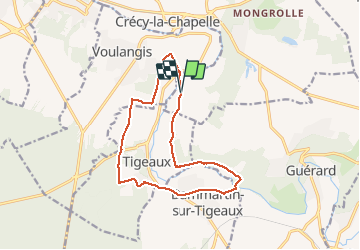
Tour Wandern von 13,2 km verfügbar auf Île-de-France, Seine-et-Marne, Crécy-la-Chapelle. Diese Tour wird von em77 vorgeschlagen.
Beschreibung
Petite randonnée sympa autour de Tigeaux. Jolies vues des deux rives de la vallée du Morin. Le terrain peut être un peu gras.
Ort
Land:
France
Region :
Île-de-France
Abteilung/Provinz :
Seine-et-Marne
Kommune :
Crécy-la-Chapelle
Standort:
Unknown
Gehen Sie:(Dec)
Gehen Sie:(UTM)
493645 ; 5409867 (31U) N.
Kommentare
Touren in der Umgebung
![Tour Wandern Crécy-la-Chapelle - Boucle 28 km autour de Crecy la Chapelle - Guérard - Voulangis - Tigeaux - Photo](https://media.geolcdn.com/t/375/260/ec792934-9951-48a4-9c10-6a048c9ff4d6.jpg&format=jpg&maxdim=2)
![Wandern Wandern](https://static1.geolcdn.com/sitytour/trail-icons/101.png)
Boucle 28 km autour de Crecy la Chapelle - Guérard - Voulangis - Tigeaux
Wandern
Medium
Crécy-la-Chapelle,
Île-de-France,
Seine-et-Marne,
France
![](/images/other/stat-length.png)
28 km | 35 km-effort
5h 46min
![](https://static1.geolcdn.com/siteimages/upload/files/16400158638029165_repeat_loop_refresh_sync_direction_icon.png)
Ja
![Tour Wandern Crécy-la-Chapelle - Crécy la Chapelle Parcours normal - Photo](https://media.geolcdn.com/t/375/260/ext.jpg?maxdim=2&url=https%3A%2F%2Fstatic1.geolcdn.com%2Fsiteimages%2Fupload%2Ffiles%2F1553511878bg_sport_marche.png)
![Wandern Wandern](https://static1.geolcdn.com/sitytour/trail-icons/101.png)
Crécy la Chapelle Parcours normal
Wandern
Einfach
(1)
Crécy-la-Chapelle,
Île-de-France,
Seine-et-Marne,
France
![](/images/other/stat-length.png)
16,1 km | 19,5 km-effort
4h 18min
![](https://static1.geolcdn.com/siteimages/upload/files/16400158638029165_repeat_loop_refresh_sync_direction_icon.png)
Ja
![Tour Wandern Crécy-la-Chapelle - Crécy la chapelle - Photo](https://media.geolcdn.com/t/375/260/ext.jpg?maxdim=2&url=https%3A%2F%2Fstatic1.geolcdn.com%2Fsiteimages%2Fupload%2Ffiles%2F1553511878bg_sport_marche.png)
![Wandern Wandern](https://static1.geolcdn.com/sitytour/trail-icons/101.png)
Crécy la chapelle
Wandern
Einfach
(2)
Crécy-la-Chapelle,
Île-de-France,
Seine-et-Marne,
France
![](/images/other/stat-length.png)
19,7 km | 24 km-effort
5h 12min
![](https://static1.geolcdn.com/siteimages/upload/files/16400158638029165_repeat_loop_refresh_sync_direction_icon.png)
Ja
![Tour Wandern Crécy-la-Chapelle - Crécy la Chapelle - Photo](https://media.geolcdn.com/t/375/260/ext.jpg?maxdim=2&url=https%3A%2F%2Fstatic1.geolcdn.com%2Fsiteimages%2Fupload%2Ffiles%2F1553511878bg_sport_marche.png)
![Wandern Wandern](https://static1.geolcdn.com/sitytour/trail-icons/101.png)
Crécy la Chapelle
Wandern
Medium
(1)
Crécy-la-Chapelle,
Île-de-France,
Seine-et-Marne,
France
![](/images/other/stat-length.png)
16,4 km | 20 km-effort
4h 23min
![](https://static1.geolcdn.com/siteimages/upload/files/16400158638029165_repeat_loop_refresh_sync_direction_icon.png)
Ja
![Tour Wandern Voulangis - Voulangis - Crécy - Villiers lqqm - Photo](https://media.geolcdn.com/t/375/260/ext.jpg?maxdim=2&url=https%3A%2F%2Fstatic1.geolcdn.com%2Fsiteimages%2Fupload%2Ffiles%2F1553511878bg_sport_marche.png)
![Wandern Wandern](https://static1.geolcdn.com/sitytour/trail-icons/101.png)
Voulangis - Crécy - Villiers lqqm
Wandern
Schwierig
(1)
Voulangis,
Île-de-France,
Seine-et-Marne,
France
![](/images/other/stat-length.png)
12,9 km | 15,7 km-effort
3h 34min
![](https://static1.geolcdn.com/siteimages/upload/files/16400158638029165_repeat_loop_refresh_sync_direction_icon.png)
Ja
![Tour Wandern Voulangis - Voulangis - Crécy - Villiers - Photo](https://media.geolcdn.com/t/375/260/ext.jpg?maxdim=2&url=https%3A%2F%2Fstatic1.geolcdn.com%2Fsiteimages%2Fupload%2Ffiles%2F1553511878bg_sport_marche.png)
![Wandern Wandern](https://static1.geolcdn.com/sitytour/trail-icons/101.png)
Voulangis - Crécy - Villiers
Wandern
Schwierig
(1)
Voulangis,
Île-de-France,
Seine-et-Marne,
France
![](/images/other/stat-length.png)
12,9 km | 15,7 km-effort
3h 34min
![](https://static1.geolcdn.com/siteimages/upload/files/16400158638029165_repeat_loop_refresh_sync_direction_icon.png)
Ja
![Tour Wandern Guérard - Guérard - Photo](https://media.geolcdn.com/t/375/260/604a5cf1-31c1-4e64-b7ed-ed1e6e2756f8.jpg&format=jpg&maxdim=2)
![Wandern Wandern](https://static1.geolcdn.com/sitytour/trail-icons/101.png)
Guérard
Wandern
Schwierig
Guérard,
Île-de-France,
Seine-et-Marne,
France
![](/images/other/stat-length.png)
15,4 km | 18,5 km-effort
4h 3min
![](https://static1.geolcdn.com/siteimages/upload/files/16400158638029165_repeat_loop_refresh_sync_direction_icon.png)
Ja
![Tour Wandern Tigeaux - Tigeaux - Photo](https://media.geolcdn.com/t/375/260/ext.jpg?maxdim=2&url=https%3A%2F%2Fstatic1.geolcdn.com%2Fsiteimages%2Fupload%2Ffiles%2F1553511878bg_sport_marche.png)
![Wandern Wandern](https://static1.geolcdn.com/sitytour/trail-icons/101.png)
Tigeaux
Wandern
Medium
(1)
Tigeaux,
Île-de-France,
Seine-et-Marne,
France
![](/images/other/stat-length.png)
19,1 km | 24 km-effort
5h 24min
![](https://static1.geolcdn.com/siteimages/upload/files/16400158638029165_repeat_loop_refresh_sync_direction_icon.png)
Ja
![Wandern Wandern](https://static1.geolcdn.com/sitytour/trail-icons/101.png)
Les coteaux du Grand Morin
Wandern
Medium
Crécy-la-Chapelle,
Île-de-France,
Seine-et-Marne,
France
![](/images/other/stat-length.png)
11,8 km | 14,3 km-effort
3h 6min
![](https://static1.geolcdn.com/siteimages/upload/files/16400158638029165_repeat_loop_refresh_sync_direction_icon.png)
Ja
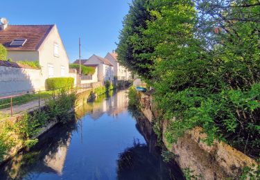
Belle randonnée pourtant proche de Paris.