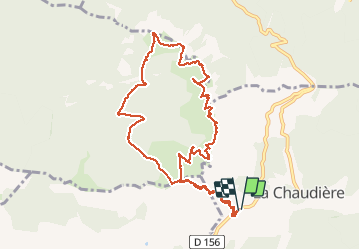
![](/images/other/stat-length.png)
![Tour Wandern La Chaudière - les trois becs - Photo](https://media.geolcdn.com/t/1900/400/ext.pjpeg?maxdim=2&url=https%3A%2F%2Fservices.sitytrail.com%2FGeolivesWS%2FDownloadMedia.ashx%3FTrailID%3D997850%26Media%3Dfix__20180701153419.jpg)
les trois becs
amiral13
Benutzer GUIDE
![Länge](/images/other/stat-length.png)
![Maximale Höhe](https://static1.geolcdn.com/siteimages/upload/files/1508320355ic_sort_altitude_max_24dp.png)
![Positive Höhendifferenz](https://static1.geolcdn.com/siteimages/upload/files/1508320355ic_sort_den_pos_24dp.png)
![Km-Effort](/images/other/stat-length.png)
![Min. Höhe](https://static1.geolcdn.com/siteimages/upload/files/1508320355ic_sort_altitude_min_24dp.png)
![Negative Höhendifferenz](https://static1.geolcdn.com/siteimages/upload/files/1508320355ic_sort_den_neg_24dp.png)
![Boucle](https://static1.geolcdn.com/siteimages/upload/files/16400158638029165_repeat_loop_refresh_sync_direction_icon.png)
![Wandern](https://static1.geolcdn.com/sitytour/trail-icons/101.png)
6h25
Schwierigkeit : Medium
![Scannen Sie diesen QR-Code, um die Tour in der SityTrail-Anwendung zu öffnen](https://capi.geolives.com/qq0zvz2zws4bq2lad0pu/sitytour/trails/997850/qr.png?size=200)
Kostenlosegpshiking-Anwendung
Über SityTrail
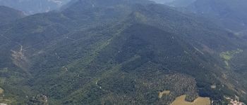
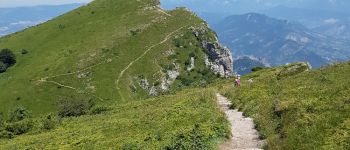
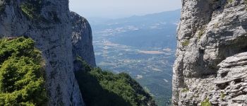
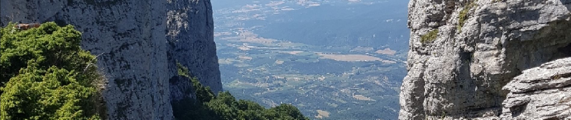
Tour Wandern von 11,7 km verfügbar auf Auvergne-Rhone-Alpen, Drôme, La Chaudière. Diese Tour wird von amiral13 vorgeschlagen.
Beschreibung
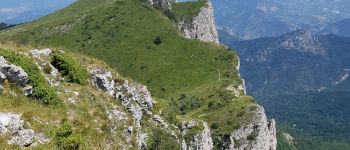
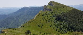
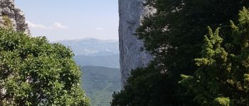
Incontournable si vous êtes dans le secteur.
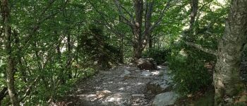
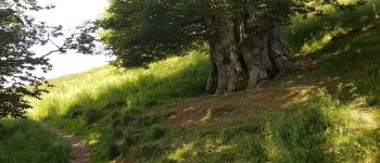
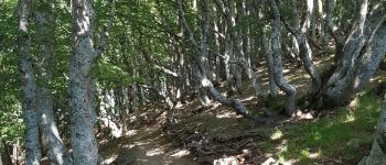
le sentier est en cours de réhabilitation avec peut-être un peu trop de marche, mais quel travail!
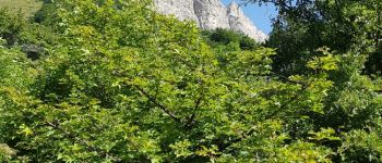
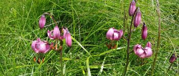
une très belle randonnée dans un magnifique cadre.
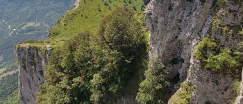
le temps de parcours est donné en randonnée familiale avec des enfants de 10 ans.
POIs
Ort
Kommentare
Touren in der Umgebung
![Tour Wandern Bourdeaux - Chemin des protestants- Bourdaux - Photo](https://media.geolcdn.com/t/375/260/c9690b91-aa42-47d0-b809-97d643432899.jpg&format=jpg&maxdim=2)
![Wandern Wandern](https://static1.geolcdn.com/sitytour/trail-icons/101.png)
Wandern
![](/images/other/stat-length.png)
![](https://static1.geolcdn.com/siteimages/upload/files/16400158638029165_repeat_loop_refresh_sync_direction_icon.png)
![Tour Wandern La Chaudière - Les 3 Becs - Photo](https://media.geolcdn.com/t/375/260/ext.jpg?maxdim=2&url=https%3A%2F%2Fservices.sitytrail.com%2FGeolivesWS%2FDownloadMedia.ashx%3FTrailID%3D218224%26Media%3Dfix__20130901120821.jpg)
![Wandern Wandern](https://static1.geolcdn.com/sitytour/trail-icons/101.png)
Wandern
![](/images/other/stat-length.png)
![](https://static1.geolcdn.com/siteimages/upload/files/16400158638029165_repeat_loop_refresh_sync_direction_icon.png)
![Tour Wandern La Chaudière - La chaudiere - chapelle des Sadoux - Photo](https://media.geolcdn.com/t/375/260/fe29fe3e-8696-4fc7-af92-f6d3eeb26877.jpg&format=jpg&maxdim=2)
![Wandern Wandern](https://static1.geolcdn.com/sitytour/trail-icons/101.png)
Wandern
![](/images/other/stat-length.png)
![](https://static1.geolcdn.com/siteimages/upload/files/16400158638029165_repeat_loop_refresh_sync_direction_icon.png)
![Tour Wandern Bézaudun-sur-Bîne - 2022-09-26_14h18m42_12295156 - Photo](https://media.geolcdn.com/t/375/260/f11da23a-0048-4e80-a120-e8dd7afb6f22.jpg&format=jpg&maxdim=2)
![Wandern Wandern](https://static1.geolcdn.com/sitytour/trail-icons/101.png)
Wandern
![](/images/other/stat-length.png)
![](https://static1.geolcdn.com/siteimages/upload/files/16400158638029165_repeat_loop_refresh_sync_direction_icon.png)
![Tour Wandern La Chaudière - les 3becs et arches - Photo](https://media.geolcdn.com/t/375/260/97464636-1260-4d97-b592-83a9cda2a983.jpg&format=jpg&maxdim=2)
![Wandern Wandern](https://static1.geolcdn.com/sitytour/trail-icons/101.png)
Wandern
![](/images/other/stat-length.png)
![](https://static1.geolcdn.com/siteimages/upload/files/16400158638029165_repeat_loop_refresh_sync_direction_icon.png)
![Tour Wandern La Chaudière - La chaudière- chapelle des Sadoux - Photo](https://media.geolcdn.com/t/375/260/6819e1ce-f278-49e2-9b64-8d59d930cfa9.jpg&format=jpg&maxdim=2)
![Wandern Wandern](https://static1.geolcdn.com/sitytour/trail-icons/101.png)
Wandern
![](/images/other/stat-length.png)
![](https://static1.geolcdn.com/siteimages/upload/files/16400158638029165_repeat_loop_refresh_sync_direction_icon.png)
![Tour Wandern Chastel-Arnaud - montagne de Farraud - Photo](https://media.geolcdn.com/t/375/260/f18555a4-364f-4c22-b353-208a3bb34108.jpg&format=jpg&maxdim=2)
![Wandern Wandern](https://static1.geolcdn.com/sitytour/trail-icons/101.png)
Wandern
![](/images/other/stat-length.png)
![](https://static1.geolcdn.com/siteimages/upload/files/16400158638029165_repeat_loop_refresh_sync_direction_icon.png)
![Tour Wandern Aubenasson - saint Michel Aubenasson - Photo](https://media.geolcdn.com/t/375/260/9cfb9e95-478d-41e2-9a6e-6de46d17856a.jpg&format=jpg&maxdim=2)
![Wandern Wandern](https://static1.geolcdn.com/sitytour/trail-icons/101.png)
Wandern
![](/images/other/stat-length.png)
![](https://static1.geolcdn.com/siteimages/upload/files/16400158638029165_repeat_loop_refresh_sync_direction_icon.png)
![Tour Wandern Bézaudun-sur-Bîne - Bèzaudun-sur-Bîne 14km. - Photo](https://media.geolcdn.com/t/375/260/6d673a6d-6a71-4890-ac2e-836b3ed377ad.jpg&format=jpg&maxdim=2)
![Wandern Wandern](https://static1.geolcdn.com/sitytour/trail-icons/101.png)
Wandern
![](/images/other/stat-length.png)
![](https://static1.geolcdn.com/siteimages/upload/files/16400158638029165_repeat_loop_refresh_sync_direction_icon.png)