![](/images/other/stat-length.png)
![Tour Wandern Marquillies - Autour de la Libaude - Marquillies - Photo](https://media.geolcdn.com/t/1900/400/ext.pjpeg?maxdim=2&url=https%3A%2F%2Fstatic1.geolcdn.com%2Fsiteimages%2Fupload%2Ffiles%2F1553511878bg_sport_marche.png)
Autour de la Libaude - Marquillies
Blourouce
Benutzer
![Länge](/images/other/stat-length.png)
Länge
11,3 km
![Maximale Höhe](https://static1.geolcdn.com/siteimages/upload/files/1508320355ic_sort_altitude_max_24dp.png)
Maximale Höhe
36 m
![Positive Höhendifferenz](https://static1.geolcdn.com/siteimages/upload/files/1508320355ic_sort_den_pos_24dp.png)
Positive Höhendifferenz
48 m
![Km-Effort](/images/other/stat-length.png)
Km-Effort
12 km
![Min. Höhe](https://static1.geolcdn.com/siteimages/upload/files/1508320355ic_sort_altitude_min_24dp.png)
Min. Höhe
18 m
![Negative Höhendifferenz](https://static1.geolcdn.com/siteimages/upload/files/1508320355ic_sort_den_neg_24dp.png)
Negative Höhendifferenz
48 m
![Boucle](https://static1.geolcdn.com/siteimages/upload/files/16400158638029165_repeat_loop_refresh_sync_direction_icon.png)
Boucle
Ja
Erstellungsdatum :
2019-01-12 16:54:14.55
Letzte Änderung :
2019-01-12 16:54:14.56
![Wandern](https://static1.geolcdn.com/sitytour/trail-icons/101.png)
2h49
Schwierigkeit : Medium
![Scannen Sie diesen QR-Code, um die Tour in der SityTrail-Anwendung zu öffnen](https://capi.geolives.com/qq0zvz2zws4bq2lad0pu/sitytour/trails/990942/qr.png?size=200)
Kostenlosegpshiking-Anwendung
Über SityTrail
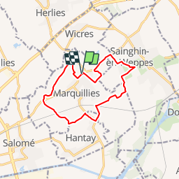
Tour Wandern von 11,3 km verfügbar auf Nordfrankreich, Nord, Marquillies. Diese Tour wird von Blourouce vorgeschlagen.
Beschreibung
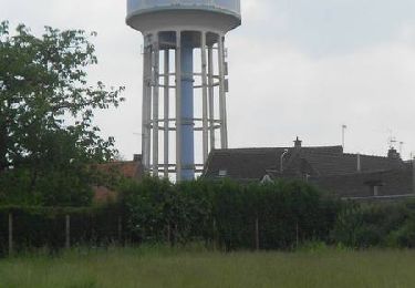
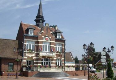
Départ de l’église de Marquillies. Parcours à dominante agricole, autour de Marquillies. Prudence le long de la RD 145 qui offre néanmoins un large bas-côté. Retrouvez cette randonnée sur le site du Comité Départemental du Tourisme du Nord.
Ort
Land:
France
Region :
Nordfrankreich
Abteilung/Provinz :
Nord
Kommune :
Marquillies
Standort:
Unknown
Gehen Sie:(Dec)
Gehen Sie:(UTM)
490760 ; 5600710 (31U) N.
Kommentare
Touren in der Umgebung
![Tour Wandern La Bassée - La Basée 13 km - Photo](https://media.geolcdn.com/t/375/260/f1bdc64b-513c-470e-8886-00ca936919a9.jpg&format=jpg&maxdim=2)
![Wandern Wandern](https://static1.geolcdn.com/sitytour/trail-icons/101.png)
La Basée 13 km
Wandern
Einfach
La Bassée,
Nordfrankreich,
Nord,
France
![](/images/other/stat-length.png)
13 km | 13,7 km-effort
3h 26min
![](https://static1.geolcdn.com/siteimages/upload/files/16400158638029165_repeat_loop_refresh_sync_direction_icon.png)
Ja
![Tour Wandern Bauvin - Wingles - Photo](https://media.geolcdn.com/t/375/260/4ad96d20-0522-45e1-a005-6177e2c8edea.jpg&format=jpg&maxdim=2)
![Wandern Wandern](https://static1.geolcdn.com/sitytour/trail-icons/101.png)
![Tour Wandern Aubers - Aubert 7.6 km Circuit du tilleul du Joncquoy - Photo](https://media.geolcdn.com/t/375/260/ext.jpg?maxdim=2&url=https%3A%2F%2Fservices.sitytrail.com%2FGeolivesWS%2FDownloadMedia.ashx%3FTrailID%3D366161%26Media%3D2e57021e-4e23-4afd-aa57-25dfb2194a07.jpg)
![Wandern Wandern](https://static1.geolcdn.com/sitytour/trail-icons/101.png)
Aubert 7.6 km Circuit du tilleul du Joncquoy
Wandern
Medium
Aubers,
Nordfrankreich,
Nord,
France
![](/images/other/stat-length.png)
7,6 km | 8,2 km-effort
2h 0min
![](https://static1.geolcdn.com/siteimages/upload/files/16400158638029165_repeat_loop_refresh_sync_direction_icon.png)
Ja
![Tour Wandern Beaucamps-Ligny - Autour de Beaucamps-Ligny - Photo](https://media.geolcdn.com/t/375/260/ext.jpg?maxdim=2&url=https%3A%2F%2Fservices.sitytrail.com%2FGeolivesWS%2FDownloadMedia.ashx%3FTrailID%3D318000%26Media%3D17453_6.jpg)
![Wandern Wandern](https://static1.geolcdn.com/sitytour/trail-icons/101.png)
Autour de Beaucamps-Ligny
Wandern
Medium
Beaucamps-Ligny,
Nordfrankreich,
Nord,
France
![](/images/other/stat-length.png)
12,8 km | 13,8 km-effort
3h 10min
![](https://static1.geolcdn.com/siteimages/upload/files/16400158638029165_repeat_loop_refresh_sync_direction_icon.png)
Ja
![Tour Wandern Fournes-en-Weppes - En Bas Flandre - Fournes en Weppes - Photo](https://media.geolcdn.com/t/375/260/ext.jpg?maxdim=2&url=https%3A%2F%2Fservices.sitytrail.com%2FGeolivesWS%2FDownloadMedia.ashx%3FTrailID%3D317989%26Media%3D17433_5.jpg)
![Wandern Wandern](https://static1.geolcdn.com/sitytour/trail-icons/101.png)
En Bas Flandre - Fournes en Weppes
Wandern
Medium
Fournes-en-Weppes,
Nordfrankreich,
Nord,
France
![](/images/other/stat-length.png)
8 km | 8,6 km-effort
2h 0min
![](https://static1.geolcdn.com/siteimages/upload/files/16400158638029165_repeat_loop_refresh_sync_direction_icon.png)
Ja
![Tour Wandern Billy-Berclau - Le chemin vert - Billy-Berclau - Photo](https://media.geolcdn.com/t/375/260/ext.jpg?maxdim=2&url=https%3A%2F%2Fservices.sitytrail.com%2FGeolivesWS%2FDownloadMedia.ashx%3FTrailID%3D317354%26Media%3D16572_6.jpg)
![Wandern Wandern](https://static1.geolcdn.com/sitytour/trail-icons/101.png)
Le chemin vert - Billy-Berclau
Wandern
Medium
Billy-Berclau,
Nordfrankreich,
Pas-de-Calais,
France
![](/images/other/stat-length.png)
9,2 km | 9,7 km-effort
2h 15min
![](https://static1.geolcdn.com/siteimages/upload/files/16400158638029165_repeat_loop_refresh_sync_direction_icon.png)
Ja
![Tour Wandern Marquillies - Autour de la Libaude - Marquillies - Photo](https://media.geolcdn.com/t/375/260/ext.jpg?maxdim=2&url=https%3A%2F%2Fservices.sitytrail.com%2FGeolivesWS%2FDownloadMedia.ashx%3FTrailID%3D109252%26Media%3D3355_6.jpg)
![Wandern Wandern](https://static1.geolcdn.com/sitytour/trail-icons/101.png)
Autour de la Libaude - Marquillies
Wandern
Medium
Marquillies,
Nordfrankreich,
Nord,
France
![](/images/other/stat-length.png)
11,3 km | 12 km-effort
2h 49min
![](https://static1.geolcdn.com/siteimages/upload/files/16400158638029165_repeat_loop_refresh_sync_direction_icon.png)
Ja
![Tour Wandern Sainghin-en-Weppes - Un siècle d'histoire à Sainghin en Weppes - Photo](https://media.geolcdn.com/t/375/260/ext.jpg?maxdim=2&url=https%3A%2F%2Fservices.sitytrail.com%2FGeolivesWS%2FDownloadMedia.ashx%3FTrailID%3D109250%26Media%3D3352_6.jpg)
![Wandern Wandern](https://static1.geolcdn.com/sitytour/trail-icons/101.png)
Un siècle d'histoire à Sainghin en Weppes
Wandern
Medium
Sainghin-en-Weppes,
Nordfrankreich,
Nord,
France
![](/images/other/stat-length.png)
11,7 km | 12,3 km-effort
2h 49min
![](https://static1.geolcdn.com/siteimages/upload/files/16400158638029165_repeat_loop_refresh_sync_direction_icon.png)
Ja
![Tour Wandern Hantay - Circuit découverte nature des Weppes - Hantay - Photo](https://media.geolcdn.com/t/375/260/ext.jpg?maxdim=2&url=https%3A%2F%2Fservices.sitytrail.com%2FGeolivesWS%2FDownloadMedia.ashx%3FTrailID%3D109236%26Media%3D3336_6.jpg)
![Wandern Wandern](https://static1.geolcdn.com/sitytour/trail-icons/101.png)
Circuit découverte nature des Weppes - Hantay
Wandern
Medium
(2)
Hantay,
Nordfrankreich,
Nord,
France
![](/images/other/stat-length.png)
9,2 km | 9,8 km-effort
2h 19min
![](https://static1.geolcdn.com/siteimages/upload/files/16400158638029165_repeat_loop_refresh_sync_direction_icon.png)
Ja