![](/images/other/stat-length.png)
![Tour Wandern Arrens-Marsous - ARRENS Turon d'ompre et cap d'aout - Photo](https://media.geolcdn.com/t/1900/400/ext.pjpeg?maxdim=2&url=https%3A%2F%2Fstatic1.geolcdn.com%2Fsiteimages%2Fupload%2Ffiles%2F1553511878bg_sport_marche.png)
ARRENS Turon d'ompre et cap d'aout
marmotte65
Benutzer GUIDE
![Länge](/images/other/stat-length.png)
Länge
8,8 km
![Maximale Höhe](https://static1.geolcdn.com/siteimages/upload/files/1508320355ic_sort_altitude_max_24dp.png)
Maximale Höhe
1649 m
![Positive Höhendifferenz](https://static1.geolcdn.com/siteimages/upload/files/1508320355ic_sort_den_pos_24dp.png)
Positive Höhendifferenz
464 m
![Km-Effort](/images/other/stat-length.png)
Km-Effort
15 km
![Min. Höhe](https://static1.geolcdn.com/siteimages/upload/files/1508320355ic_sort_altitude_min_24dp.png)
Min. Höhe
1181 m
![Negative Höhendifferenz](https://static1.geolcdn.com/siteimages/upload/files/1508320355ic_sort_den_neg_24dp.png)
Negative Höhendifferenz
469 m
![Boucle](https://static1.geolcdn.com/siteimages/upload/files/16400158638029165_repeat_loop_refresh_sync_direction_icon.png)
Boucle
Ja
Erstellungsdatum :
2018-06-26 15:33:33.133
Letzte Änderung :
2020-01-10 11:32:00.069
![Wandern](https://static1.geolcdn.com/sitytour/trail-icons/101.png)
3h08
Schwierigkeit : Unbekannt
![Scannen Sie diesen QR-Code, um die Tour in der SityTrail-Anwendung zu öffnen](https://capi.geolives.com/qq0zvz2zws4bq2lad0pu/sitytour/trails/979770/qr.png?size=200)
Kostenlosegpshiking-Anwendung
Über SityTrail
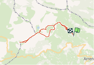
Tour Wandern von 8,8 km verfügbar auf Okzitanien, Hautes-Pyrénées, Arrens-Marsous. Diese Tour wird von marmotte65 vorgeschlagen.
Beschreibung
9km/502M
sens horaire
coordonnées départ à la cote 1183m
N42° 58' 14.6"
a Arrens prendre vers le soulor et apres une epingle a cheveus prendre le chemin des artigaux jusqu'a Artigaus (4km environ depuis arrens )
W000° 13'23.0"
Ort
Land:
France
Region :
Okzitanien
Abteilung/Provinz :
Hautes-Pyrénées
Kommune :
Arrens-Marsous
Standort:
Unknown
Gehen Sie:(Dec)
Gehen Sie:(UTM)
726458 ; 4761305 (30T) N.
Kommentare
Touren in der Umgebung
![Tour Schneeschuhwandern Aucun - Le Soum de Berducou - Photo](https://media.geolcdn.com/t/375/260/ext.jpg?maxdim=2&url=https%3A%2F%2Fservices.sitytrail.com%2FGeolivesWS%2FDownloadMedia.ashx%3FTrailID%3D110337%26Media%3D5784_1.jpg)
![Schneeschuhwandern Schneeschuhwandern](https://static1.geolcdn.com/sitytour/trail-icons/504.png)
Le Soum de Berducou
Schneeschuhwandern
Medium
(1)
Aucun,
Okzitanien,
Hautes-Pyrénées,
France
![](/images/other/stat-length.png)
5,3 km | 9,6 km-effort
3h 15min
![](https://static1.geolcdn.com/siteimages/upload/files/16400158638029165_repeat_loop_refresh_sync_direction_icon.png)
Ja
![Tour Wandern Gaillagos - GAILLAGOS / Couret / Couraduque en boucle reco G3 - Photo](https://media.geolcdn.com/t/375/260/2bb3641c-adfa-48ae-af2a-1b58bf8f8276.jpg&format=jpg&maxdim=2)
![Wandern Wandern](https://static1.geolcdn.com/sitytour/trail-icons/101.png)
GAILLAGOS / Couret / Couraduque en boucle reco G3
Wandern
Schwierig
Gaillagos,
Okzitanien,
Hautes-Pyrénées,
France
![](/images/other/stat-length.png)
8,4 km | 14,3 km-effort
2h 30min
![](https://static1.geolcdn.com/siteimages/upload/files/16400158638029165_repeat_loop_refresh_sync_direction_icon.png)
Ja
![Tour Wandern Arrens-Marsous - ARRENS MARSOUS Le Turon des aulhes 2906361 - Photo](https://media.geolcdn.com/t/375/260/11ee13f3-f703-440e-9be7-4acb8ea55d91.jpg&format=jpg&maxdim=2)
![Wandern Wandern](https://static1.geolcdn.com/sitytour/trail-icons/101.png)
ARRENS MARSOUS Le Turon des aulhes 2906361
Wandern
Medium
(1)
Arrens-Marsous,
Okzitanien,
Hautes-Pyrénées,
France
![](/images/other/stat-length.png)
9,5 km | 16,4 km-effort
5h 55min
![](https://static1.geolcdn.com/siteimages/upload/files/16400158638029165_repeat_loop_refresh_sync_direction_icon.png)
Ja
![Tour Wintersport Aucun - couraduc soulor - Photo](https://media.geolcdn.com/t/375/260/ext.jpg?maxdim=2&url=https%3A%2F%2Fstatic1.geolcdn.com%2Fsiteimages%2Fupload%2Ffiles%2F1524743153ski.jpg)
![Wintersport Wintersport](https://static1.geolcdn.com/sitytour/trail-icons/500.png)
couraduc soulor
Wintersport
Schwierig
(1)
Aucun,
Okzitanien,
Hautes-Pyrénées,
France
![](/images/other/stat-length.png)
34 km | 45 km-effort
2h 31min
![](https://static1.geolcdn.com/siteimages/upload/files/16400158638029165_repeat_loop_refresh_sync_direction_icon.png)
Ja
![Tour Wintersport Aucun - Bazes soulor - Photo](https://media.geolcdn.com/t/375/260/ext.jpg?maxdim=2&url=https%3A%2F%2Fstatic1.geolcdn.com%2Fsiteimages%2Fupload%2Ffiles%2F1524743153ski.jpg)
![Wintersport Wintersport](https://static1.geolcdn.com/sitytour/trail-icons/500.png)
Bazes soulor
Wintersport
Medium
(1)
Aucun,
Okzitanien,
Hautes-Pyrénées,
France
![](/images/other/stat-length.png)
25 km | 34 km-effort
2h 4min
![](https://static1.geolcdn.com/siteimages/upload/files/16400158638029165_repeat_loop_refresh_sync_direction_icon.png)
Ja
![Tour Wandern Arrens-Marsous - col de soulor, lac de soum, col de bazes, col de soulor - Photo](https://media.geolcdn.com/t/375/260/9c3094c8-45a9-4b5a-9dd6-274e8c565d12.jpg&format=jpg&maxdim=2)
![Wandern Wandern](https://static1.geolcdn.com/sitytour/trail-icons/101.png)
col de soulor, lac de soum, col de bazes, col de soulor
Wandern
Medium
Arrens-Marsous,
Okzitanien,
Hautes-Pyrénées,
France
![](/images/other/stat-length.png)
16,4 km | 23 km-effort
5h 20min
![](https://static1.geolcdn.com/siteimages/upload/files/16400158638029165_repeat_loop_refresh_sync_direction_icon.png)
Ja
![Tour Wandern Gaillagos - GAILLAGOS Col de Couret Couraduque en boucle G3 du 21/04/2023](https://media.geolcdn.com/t/375/260/a7a6faba-e7ef-4e8d-a26e-e7db5f8feac1.jpg&format=jpg&maxdim=2)
![Wandern Wandern](https://static1.geolcdn.com/sitytour/trail-icons/101.png)
GAILLAGOS Col de Couret Couraduque en boucle G3 du 21/04/2023"3630206"
Wandern
Schwierig
Gaillagos,
Okzitanien,
Hautes-Pyrénées,
France
![](/images/other/stat-length.png)
8,2 km | 14,2 km-effort
2h 46min
![](https://static1.geolcdn.com/siteimages/upload/files/16400158638029165_repeat_loop_refresh_sync_direction_icon.png)
Ja
![Tour Wandern Aucun - Lac de Soum depuis Col de Couraduque en boucle - Photo](https://media.geolcdn.com/t/375/260/796fccc8-4f12-43e4-93ad-e83b0e4ee94e.jpg&format=jpg&maxdim=2)
![Wandern Wandern](https://static1.geolcdn.com/sitytour/trail-icons/101.png)
Lac de Soum depuis Col de Couraduque en boucle
Wandern
Einfach
Aucun,
Okzitanien,
Hautes-Pyrénées,
France
![](/images/other/stat-length.png)
11,9 km | 18,2 km-effort
4h 36min
![](https://static1.geolcdn.com/siteimages/upload/files/16400158638029165_repeat_loop_refresh_sync_direction_icon.png)
Ja
![Tour Wandern Arrens-Marsous - ARRENS-MARSOUS le chemin de la mine G4 3059377 - Photo](https://media.geolcdn.com/t/375/260/518ded4d-66a4-45f9-be9c-992637e83008.jpg&format=jpg&maxdim=2)
![Wandern Wandern](https://static1.geolcdn.com/sitytour/trail-icons/101.png)
ARRENS-MARSOUS le chemin de la mine G4 3059377
Wandern
Medium
Arrens-Marsous,
Okzitanien,
Hautes-Pyrénées,
France
![](/images/other/stat-length.png)
11,2 km | 14,6 km-effort
3h 23min
![](https://static1.geolcdn.com/siteimages/upload/files/16400158638029165_repeat_loop_refresh_sync_direction_icon.png)
Ja