![](/images/other/stat-length.png)
![Tour Wandern Sagres - Plage du Telheiro - Photo](https://media.geolcdn.com/t/1900/400/ext.pjpeg?maxdim=2&url=https%3A%2F%2Fstatic1.geolcdn.com%2Fsiteimages%2Fupload%2Ffiles%2F1553511878bg_sport_marche.png)
Plage du Telheiro
rigol05
Benutzer
![Länge](/images/other/stat-length.png)
Länge
15,2 km
![Maximale Höhe](https://static1.geolcdn.com/siteimages/upload/files/1508320355ic_sort_altitude_max_24dp.png)
Maximale Höhe
98 m
![Positive Höhendifferenz](https://static1.geolcdn.com/siteimages/upload/files/1508320355ic_sort_den_pos_24dp.png)
Positive Höhendifferenz
205 m
![Km-Effort](/images/other/stat-length.png)
Km-Effort
17,9 km
![Min. Höhe](https://static1.geolcdn.com/siteimages/upload/files/1508320355ic_sort_altitude_min_24dp.png)
Min. Höhe
24 m
![Negative Höhendifferenz](https://static1.geolcdn.com/siteimages/upload/files/1508320355ic_sort_den_neg_24dp.png)
Negative Höhendifferenz
209 m
![Boucle](https://static1.geolcdn.com/siteimages/upload/files/16400158638029165_repeat_loop_refresh_sync_direction_icon.png)
Boucle
Ja
Erstellungsdatum :
2018-06-26 14:53:48.148
Letzte Änderung :
2018-06-26 14:53:48.148
![Wandern](https://static1.geolcdn.com/sitytour/trail-icons/101.png)
3h56
Schwierigkeit : Unbekannt
![Scannen Sie diesen QR-Code, um die Tour in der SityTrail-Anwendung zu öffnen](https://capi.geolives.com/qq0zvz2zws4bq2lad0pu/sitytour/trails/973752/qr.png?size=200)
Kostenlosegpshiking-Anwendung
Über SityTrail
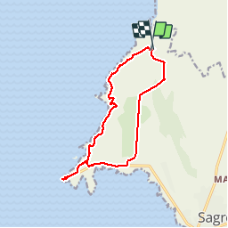
Tour Wandern von 15,2 km verfügbar auf Algarve, Faro, Sagres. Diese Tour wird von rigol05 vorgeschlagen.
Beschreibung
sortie du 14-05
Départ de Ponta Ruiva suivre la piste sur 6km depuis Vila do Bispo. Au retour l'itinéraire manque d'intérêt (trop de route)De Ponta Ruiva au Cabo S.Vicente le sentier suivant la côte est magnifique. Le départ sud à partir du cap St. Vincent est plus accessible donc préférable.
Ort
Land:
Portugal
Region :
Algarve
Abteilung/Provinz :
Faro
Kommune :
Sagres
Standort:
Unknown
Gehen Sie:(Dec)
Gehen Sie:(UTM)
503306 ; 4101858 (29S) N.
Kommentare
Touren in der Umgebung
![Tour Wandern - Sagres cap St VINCENT Carrapateria - Photo](https://media.geolcdn.com/t/375/260/5fbc8ff6-bcde-4b54-961a-80919cd27a85.jpg&format=jpg&maxdim=2)
![Wandern Wandern](https://static1.geolcdn.com/sitytour/trail-icons/101.png)
Sagres cap St VINCENT Carrapateria
Wandern
Medium
,
Algarve,
Faro,
Portugal
![](/images/other/stat-length.png)
40 km | 50 km-effort
12h 35min
![](https://static1.geolcdn.com/siteimages/upload/files/16400158638029165_repeat_loop_refresh_sync_direction_icon.png)
Nein
![Tour Wandern Vila do Bispo e Raposeira - ALGARVE - En route pour le Ponte de Aspa - Photo](https://media.geolcdn.com/t/375/260/d7881009-8f96-4881-96b4-bb90c83d4140.jpg&format=jpg&maxdim=2)
![Wandern Wandern](https://static1.geolcdn.com/sitytour/trail-icons/101.png)
ALGARVE - En route pour le Ponte de Aspa
Wandern
Medium
Vila do Bispo e Raposeira,
Algarve,
Faro,
Portugal
![](/images/other/stat-length.png)
16 km | 20 km-effort
4h 56min
![](https://static1.geolcdn.com/siteimages/upload/files/16400158638029165_repeat_loop_refresh_sync_direction_icon.png)
Ja
![Tour Wandern Sagres - ALGARVE - Grande boucle près du Cabo de São Vicente - Photo](https://media.geolcdn.com/t/375/260/5ce2cd61-df05-4c2d-8c5b-68f54945868c.jpg&format=jpg&maxdim=2)
![Wandern Wandern](https://static1.geolcdn.com/sitytour/trail-icons/101.png)
ALGARVE - Grande boucle près du Cabo de São Vicente
Wandern
Medium
Sagres,
Algarve,
Faro,
Portugal
![](/images/other/stat-length.png)
15,5 km | 18,7 km-effort
4h 41min
![](https://static1.geolcdn.com/siteimages/upload/files/16400158638029165_repeat_loop_refresh_sync_direction_icon.png)
Ja
![Tour Wandern Vila do Bispo e Raposeira - Boucle de Ponte de Aspa - Photo](https://media.geolcdn.com/t/375/260/ext.jpg?maxdim=2&url=https%3A%2F%2Fstatic1.geolcdn.com%2Fsiteimages%2Fupload%2Ffiles%2F1553511878bg_sport_marche.png)
![Wandern Wandern](https://static1.geolcdn.com/sitytour/trail-icons/101.png)
Boucle de Ponte de Aspa
Wandern
Medium
Vila do Bispo e Raposeira,
Algarve,
Faro,
Portugal
![](/images/other/stat-length.png)
15,9 km | 21 km-effort
3h 48min
![](https://static1.geolcdn.com/siteimages/upload/files/16400158638029165_repeat_loop_refresh_sync_direction_icon.png)
Ja
![Tour Wandern Sagres - Sages - Cabo de São Vincent 9-10-2019 - Photo](https://media.geolcdn.com/t/375/260/ext.jpg?maxdim=2&url=https%3A%2F%2Fstatic1.geolcdn.com%2Fsiteimages%2Fupload%2Ffiles%2F1553511878bg_sport_marche.png)
![Wandern Wandern](https://static1.geolcdn.com/sitytour/trail-icons/101.png)
Sages - Cabo de São Vincent 9-10-2019
Wandern
Einfach
Sagres,
Algarve,
Faro,
Portugal
![](/images/other/stat-length.png)
9,5 km | 12 km-effort
2h 44min
![](https://static1.geolcdn.com/siteimages/upload/files/16400158638029165_repeat_loop_refresh_sync_direction_icon.png)
Ja
![Tour Wandern Vila do Bispo e Raposeira - Portugal II Étape 9 Sagres - Photo](https://media.geolcdn.com/t/375/260/ext.jpg?maxdim=2&url=https%3A%2F%2Fstatic1.geolcdn.com%2Fsiteimages%2Fupload%2Ffiles%2F1553511878bg_sport_marche.png)
![Wandern Wandern](https://static1.geolcdn.com/sitytour/trail-icons/101.png)
Portugal II Étape 9 Sagres
Wandern
Medium
Vila do Bispo e Raposeira,
Algarve,
Faro,
Portugal
![](/images/other/stat-length.png)
22 km | 26 km-effort
5h 45min
![](https://static1.geolcdn.com/siteimages/upload/files/16400158638029165_repeat_loop_refresh_sync_direction_icon.png)
Nein
![Tour Wandern Sagres - Sagres 20230919 - Photo](https://media.geolcdn.com/t/375/260/ext.jpg?maxdim=2&url=https%3A%2F%2Fstatic1.geolcdn.com%2Fsiteimages%2Fupload%2Ffiles%2F1553511878bg_sport_marche.png)
![Wandern Wandern](https://static1.geolcdn.com/sitytour/trail-icons/101.png)
![Tour Wandern Vila do Bispo e Raposeira - PT 03 - Photo](https://media.geolcdn.com/t/375/260/ext.jpg?maxdim=2&url=https%3A%2F%2Fstatic1.geolcdn.com%2Fsiteimages%2Fupload%2Ffiles%2F1553511878bg_sport_marche.png)
![Wandern Wandern](https://static1.geolcdn.com/sitytour/trail-icons/101.png)
PT 03
Wandern
Einfach
Vila do Bispo e Raposeira,
Algarve,
Faro,
Portugal
![](/images/other/stat-length.png)
13,9 km | 16,3 km-effort
5h 0min
![](https://static1.geolcdn.com/siteimages/upload/files/16400158638029165_repeat_loop_refresh_sync_direction_icon.png)
Nein
![Tour Wandern Vila do Bispo e Raposeira - ponte de Aspa - Photo](https://media.geolcdn.com/t/375/260/ext.jpg?maxdim=2&url=https%3A%2F%2Fstatic1.geolcdn.com%2Fsiteimages%2Fupload%2Ffiles%2F1553511878bg_sport_marche.png)
![Wandern Wandern](https://static1.geolcdn.com/sitytour/trail-icons/101.png)
ponte de Aspa
Wandern
Medium
Vila do Bispo e Raposeira,
Algarve,
Faro,
Portugal
![](/images/other/stat-length.png)
15,7 km | 20 km-effort
3h 54min
![](https://static1.geolcdn.com/siteimages/upload/files/16400158638029165_repeat_loop_refresh_sync_direction_icon.png)
Ja