![](/images/other/stat-length.png)
![Tour Wandern Plessé - Circuit du Coudray La Marquise - PLESSE - Photo](https://media.geolcdn.com/t/1900/400/ext.pjpeg?maxdim=2&url=https%3A%2F%2Fstatic1.geolcdn.com%2Fsiteimages%2Fupload%2Ffiles%2F1553511878bg_sport_marche.png)
Circuit du Coudray La Marquise - PLESSE
smu44
Benutzer
![Länge](/images/other/stat-length.png)
Länge
12,2 km
![Maximale Höhe](https://static1.geolcdn.com/siteimages/upload/files/1508320355ic_sort_altitude_max_24dp.png)
Maximale Höhe
58 m
![Positive Höhendifferenz](https://static1.geolcdn.com/siteimages/upload/files/1508320355ic_sort_den_pos_24dp.png)
Positive Höhendifferenz
84 m
![Km-Effort](/images/other/stat-length.png)
Km-Effort
13,3 km
![Min. Höhe](https://static1.geolcdn.com/siteimages/upload/files/1508320355ic_sort_altitude_min_24dp.png)
Min. Höhe
26 m
![Negative Höhendifferenz](https://static1.geolcdn.com/siteimages/upload/files/1508320355ic_sort_den_neg_24dp.png)
Negative Höhendifferenz
84 m
![Boucle](https://static1.geolcdn.com/siteimages/upload/files/16400158638029165_repeat_loop_refresh_sync_direction_icon.png)
Boucle
Ja
Erstellungsdatum :
2018-06-26 13:07:32.694
Letzte Änderung :
2018-06-26 13:07:32.694
![Wandern](https://static1.geolcdn.com/sitytour/trail-icons/101.png)
2h57
Schwierigkeit : Einfach
![Scannen Sie diesen QR-Code, um die Tour in der SityTrail-Anwendung zu öffnen](https://capi.geolives.com/qq0zvz2zws4bq2lad0pu/sitytour/trails/957561/qr.png?size=200)
Kostenlosegpshiking-Anwendung
Über SityTrail
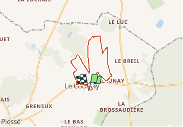
Tour Wandern von 12,2 km verfügbar auf Pays de la Loire, Loire-Atlantique, Plessé. Diese Tour wird von smu44 vorgeschlagen.
Beschreibung
Le circuit de la Marquise au Coudray évoque le passé ferroviaire de cette section de commune de Plessé, traversée par la ligne St Malo - Hendaye, comme le prouve la Marquise au centre-bourg dernier témoin de cette époque. Un circuit facile à faire en famille.Modifié: 2 ans
Ort
Land:
France
Region :
Pays de la Loire
Abteilung/Provinz :
Loire-Atlantique
Kommune :
Plessé
Standort:
Unknown
Gehen Sie:(Dec)
Gehen Sie:(UTM)
587765 ; 5267594 (30T) N.
Kommentare
Touren in der Umgebung
![Tour Wandern Le Gâvre - 7.8.2019 Forêt du Gavre - Photo](https://media.geolcdn.com/t/375/260/f9cf14e8-928c-443f-a037-337d0befb490.jpg&format=jpg&maxdim=2)
![Wandern Wandern](https://static1.geolcdn.com/sitytour/trail-icons/101.png)
7.8.2019 Forêt du Gavre
Wandern
Medium
Le Gâvre,
Pays de la Loire,
Loire-Atlantique,
France
![](/images/other/stat-length.png)
22 km | 25 km-effort
7h 48min
![](https://static1.geolcdn.com/siteimages/upload/files/16400158638029165_repeat_loop_refresh_sync_direction_icon.png)
Ja
![Tour Wandern Le Gâvre - 07.08.2019 - GÂVRE nord et Clégreuc - Photo](https://media.geolcdn.com/t/375/260/50e63918-d990-4d20-974b-f7cef55e5682.jpg&format=jpg&maxdim=2)
![Wandern Wandern](https://static1.geolcdn.com/sitytour/trail-icons/101.png)
07.08.2019 - GÂVRE nord et Clégreuc
Wandern
Medium
Le Gâvre,
Pays de la Loire,
Loire-Atlantique,
France
![](/images/other/stat-length.png)
24 km | 27 km-effort
8h 8min
![](https://static1.geolcdn.com/siteimages/upload/files/16400158638029165_repeat_loop_refresh_sync_direction_icon.png)
Ja
![Tour Wandern Guémené-Penfao - 03.07.2019 - AUTOUR DE GUÉMENÉ-PENFAO - Photo](https://media.geolcdn.com/t/375/260/ac57c8d4-c307-429a-b3e2-ff98749136b0.jpg&format=jpg&maxdim=2)
![Wandern Wandern](https://static1.geolcdn.com/sitytour/trail-icons/101.png)
03.07.2019 - AUTOUR DE GUÉMENÉ-PENFAO
Wandern
Schwierig
Guémené-Penfao,
Pays de la Loire,
Loire-Atlantique,
France
![](/images/other/stat-length.png)
28 km | 0 m-effort
6h 55min
![](https://static1.geolcdn.com/siteimages/upload/files/16400158638029165_repeat_loop_refresh_sync_direction_icon.png)
Ja
![Tour Pferd Le Gâvre - gavre072016 - Photo](https://media.geolcdn.com/t/375/260/ext.jpg?maxdim=2&url=https%3A%2F%2Fservices.sitytrail.com%2FGeolivesWS%2FDownloadMedia.ashx%3FTrailID%3D606974%26Media%3Dfix__20160701105728.jpg)
![Pferd Pferd](https://static1.geolcdn.com/sitytour/trail-icons/300.png)
gavre072016
Pferd
Sehr leicht
Le Gâvre,
Pays de la Loire,
Loire-Atlantique,
France
![](/images/other/stat-length.png)
32 km | 36 km-effort
4h 36min
![](https://static1.geolcdn.com/siteimages/upload/files/16400158638029165_repeat_loop_refresh_sync_direction_icon.png)
Ja
![Tour Pferd Le Gâvre - gavre juillet 2016 - Photo](https://media.geolcdn.com/t/375/260/ext.jpg?maxdim=2&url=https%3A%2F%2Fservices.sitytrail.com%2FGeolivesWS%2FDownloadMedia.ashx%3FTrailID%3D591466%26Media%3Dfix__20160701164833.jpg)
![Pferd Pferd](https://static1.geolcdn.com/sitytour/trail-icons/300.png)
gavre juillet 2016
Pferd
Sehr leicht
Le Gâvre,
Pays de la Loire,
Loire-Atlantique,
France
![](/images/other/stat-length.png)
31 km | 35 km-effort
4h 31min
![](https://static1.geolcdn.com/siteimages/upload/files/16400158638029165_repeat_loop_refresh_sync_direction_icon.png)
Ja
![Tour Wandern Plessé - Circuit de la Marquise - Plessé - Photo](https://media.geolcdn.com/t/375/260/ext.jpg?maxdim=2&url=https%3A%2F%2Fservices.sitytrail.com%2FGeolivesWS%2FDownloadMedia.ashx%3FTrailID%3D111706%26Media%3D8014_1.jpg)
![Wandern Wandern](https://static1.geolcdn.com/sitytour/trail-icons/101.png)
Circuit de la Marquise - Plessé
Wandern
Medium
Plessé,
Pays de la Loire,
Loire-Atlantique,
France
![](/images/other/stat-length.png)
11,8 km | 12,9 km-effort
3h 0min
![](https://static1.geolcdn.com/siteimages/upload/files/16400158638029165_repeat_loop_refresh_sync_direction_icon.png)
Ja
![Tour Auto Le Gâvre - 2024-10-29 RB l eGavre - Photo](https://media.geolcdn.com/t/375/260/ext.jpg?maxdim=2&url=https%3A%2F%2Fstatic1.geolcdn.com%2Fsiteimages%2Fupload%2Ffiles%2F15247431544x4.jpg)
![Auto Auto](https://static1.geolcdn.com/sitytour/trail-icons/401.png)
2024-10-29 RB l eGavre
Auto
Le Gâvre,
Pays de la Loire,
Loire-Atlantique,
France
![](/images/other/stat-length.png)
24 km | 26 km-effort
2h 41min
![](https://static1.geolcdn.com/siteimages/upload/files/16400158638029165_repeat_loop_refresh_sync_direction_icon.png)
Ja
![Tour Auto Le Gâvre - 2024-10-01 RB Le Gavre - Photo](https://media.geolcdn.com/t/375/260/ext.jpg?maxdim=2&url=https%3A%2F%2Fstatic1.geolcdn.com%2Fsiteimages%2Fupload%2Ffiles%2F15247431544x4.jpg)
![Auto Auto](https://static1.geolcdn.com/sitytour/trail-icons/401.png)
2024-10-01 RB Le Gavre
Auto
Le Gâvre,
Pays de la Loire,
Loire-Atlantique,
France
![](/images/other/stat-length.png)
47 km | 52 km-effort
3h 58min
![](https://static1.geolcdn.com/siteimages/upload/files/16400158638029165_repeat_loop_refresh_sync_direction_icon.png)
Nein
![Tour Reiten Le Gâvre - Le gavre 7km - Photo](https://media.geolcdn.com/t/375/260/ext.jpg?maxdim=2&url=https%3A%2F%2Fstatic1.geolcdn.com%2Fsiteimages%2Fupload%2Ffiles%2F1524743154cheval.jpg)
![Reiten Reiten](https://static1.geolcdn.com/sitytour/trail-icons/301.png)
Le gavre 7km
Reiten
Einfach
Le Gâvre,
Pays de la Loire,
Loire-Atlantique,
France
![](/images/other/stat-length.png)
6,8 km | 7,5 km-effort
1h 6min
![](https://static1.geolcdn.com/siteimages/upload/files/16400158638029165_repeat_loop_refresh_sync_direction_icon.png)
Ja