![](/images/other/stat-length.png)
![Tour Laufen Tartas - Tartas épate - Photo](https://media.geolcdn.com/t/1900/400/ext.pjpeg?maxdim=2&url=https%3A%2F%2Fstatic1.geolcdn.com%2Fsiteimages%2Fupload%2Ffiles%2F1524743154running.jpg)
Tartas épate
Valery01
Benutzer
![Länge](/images/other/stat-length.png)
Länge
11,9 km
![Maximale Höhe](https://static1.geolcdn.com/siteimages/upload/files/1508320355ic_sort_altitude_max_24dp.png)
Maximale Höhe
71 m
![Positive Höhendifferenz](https://static1.geolcdn.com/siteimages/upload/files/1508320355ic_sort_den_pos_24dp.png)
Positive Höhendifferenz
114 m
![Km-Effort](/images/other/stat-length.png)
Km-Effort
13,4 km
![Min. Höhe](https://static1.geolcdn.com/siteimages/upload/files/1508320355ic_sort_altitude_min_24dp.png)
Min. Höhe
15 m
![Negative Höhendifferenz](https://static1.geolcdn.com/siteimages/upload/files/1508320355ic_sort_den_neg_24dp.png)
Negative Höhendifferenz
102 m
![Boucle](https://static1.geolcdn.com/siteimages/upload/files/16400158638029165_repeat_loop_refresh_sync_direction_icon.png)
Boucle
Nein
Erstellungsdatum :
2018-06-26 12:46:48.603
Letzte Änderung :
2021-07-22 13:06:18.755
![Laufen](https://static1.geolcdn.com/sitytour/trail-icons/103.png)
1h16
Schwierigkeit : Unbekannt
![Scannen Sie diesen QR-Code, um die Tour in der SityTrail-Anwendung zu öffnen](https://capi.geolives.com/qq0zvz2zws4bq2lad0pu/sitytour/trails/954400/qr.png?size=200)
Kostenlosegpshiking-Anwendung
Über SityTrail
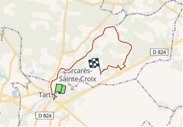
Tour Laufen von 11,9 km verfügbar auf Neu-Aquitanien, Landes, Tartas. Diese Tour wird von Valery01 vorgeschlagen.
Beschreibung
Course à pieds interrompu à Laborde par morsure de Berger malinois. 3 points de sutures
Je n'étais pas sur la voie publique mais entre le champs et le ferme.
Passage à éviter. Depuis j'ai modifié mes parcours.
Ort
Land:
France
Region :
Neu-Aquitanien
Abteilung/Provinz :
Landes
Kommune :
Tartas
Standort:
Unknown
Gehen Sie:(Dec)
Gehen Sie:(UTM)
676417 ; 4855280 (30T) N.
Kommentare
Touren in der Umgebung
![Tour Mountainbike Tartas - VTT à Tartas - Photo](https://media.geolcdn.com/t/375/260/ext.jpg?maxdim=2&url=https%3A%2F%2Fstatic1.geolcdn.com%2Fsiteimages%2Fupload%2Ffiles%2F1524743154velo.jpg)
![Mountainbike Mountainbike](https://static1.geolcdn.com/sitytour/trail-icons/202.png)
VTT à Tartas
Mountainbike
Schwierig
(1)
Tartas,
Neu-Aquitanien,
Landes,
France
![](/images/other/stat-length.png)
33 km | 37 km-effort
2h 15min
![](https://static1.geolcdn.com/siteimages/upload/files/16400158638029165_repeat_loop_refresh_sync_direction_icon.png)
Ja
![Tour Mountainbike Tartas - Rando VTT autour de Tartas - Photo](https://media.geolcdn.com/t/375/260/ext.jpg?maxdim=2&url=https%3A%2F%2Fstatic1.geolcdn.com%2Fsiteimages%2Fupload%2Ffiles%2F1524743154velo.jpg)
![Mountainbike Mountainbike](https://static1.geolcdn.com/sitytour/trail-icons/202.png)
Rando VTT autour de Tartas
Mountainbike
Schwierig
Tartas,
Neu-Aquitanien,
Landes,
France
![](/images/other/stat-length.png)
45 km | 51 km-effort
3h 30min
![](https://static1.geolcdn.com/siteimages/upload/files/16400158638029165_repeat_loop_refresh_sync_direction_icon.png)
Ja
![Tour Wandern Carcarès-Sainte-Croix - Carcarès marche du Conseil Général - 7.4 - Photo](https://media.geolcdn.com/t/375/260/ext.jpg?maxdim=2&url=https%3A%2F%2Fstatic1.geolcdn.com%2Fsiteimages%2Fupload%2Ffiles%2F1553511878bg_sport_marche.png)
![Wandern Wandern](https://static1.geolcdn.com/sitytour/trail-icons/101.png)
Carcarès marche du Conseil Général - 7.4
Wandern
Medium
Carcarès-Sainte-Croix,
Neu-Aquitanien,
Landes,
France
![](/images/other/stat-length.png)
7,4 km | 8,7 km-effort
1h 59min
![](https://static1.geolcdn.com/siteimages/upload/files/16400158638029165_repeat_loop_refresh_sync_direction_icon.png)
Ja
![Tour Wandern Carcarès-Sainte-Croix - Carcarès CG - Photo](https://media.geolcdn.com/t/375/260/ext.jpg?maxdim=2&url=https%3A%2F%2Fstatic1.geolcdn.com%2Fsiteimages%2Fupload%2Ffiles%2F1553511878bg_sport_marche.png)
![Wandern Wandern](https://static1.geolcdn.com/sitytour/trail-icons/101.png)
Carcarès CG
Wandern
Medium
Carcarès-Sainte-Croix,
Neu-Aquitanien,
Landes,
France
![](/images/other/stat-length.png)
9,4 km | 11,1 km-effort
2h 30min
![](https://static1.geolcdn.com/siteimages/upload/files/16400158638029165_repeat_loop_refresh_sync_direction_icon.png)
Ja
![Tour Wandern Bégaar - 11/4 - Photo](https://media.geolcdn.com/t/375/260/ext.jpg?maxdim=2&url=https%3A%2F%2Fstatic1.geolcdn.com%2Fsiteimages%2Fupload%2Ffiles%2F1553511878bg_sport_marche.png)
![Wandern Wandern](https://static1.geolcdn.com/sitytour/trail-icons/101.png)
![Tour Zu Fuß Bégaar - Bégaar, Tartas sur les bords de la Midouze jusqu'à l'Adour - 10 - Photo](https://media.geolcdn.com/t/375/260/ext.jpg?maxdim=2&url=https%3A%2F%2Fstatic1.geolcdn.com%2Fsiteimages%2Fupload%2Ffiles%2F1545311037marcheuse_200dpi.jpg)
![Zu Fuß Zu Fuß](https://static1.geolcdn.com/sitytour/trail-icons/100.png)
Bégaar, Tartas sur les bords de la Midouze jusqu'à l'Adour - 10
Zu Fuß
Einfach
Bégaar,
Neu-Aquitanien,
Landes,
France
![](/images/other/stat-length.png)
10,2 km | 10,8 km-effort
2h 27min
![](https://static1.geolcdn.com/siteimages/upload/files/16400158638029165_repeat_loop_refresh_sync_direction_icon.png)
Ja
![Tour sport Bégaar - begaar_765km-16411291-1679645205-439 - Photo](https://media.geolcdn.com/t/375/260/ext.jpg?maxdim=2&url=https%3A%2F%2Fsecurestorage.geolives.com%2Fsitytour%2Ftrail-bg%2Fdefault.jpg)
begaar_765km-16411291-1679645205-439
sport
Sehr leicht
Bégaar,
Neu-Aquitanien,
Landes,
France
![](/images/other/stat-length.png)
7,6 km | 8,3 km-effort
Unbekannt
![](https://static1.geolcdn.com/siteimages/upload/files/16400158638029165_repeat_loop_refresh_sync_direction_icon.png)
Ja
![Tour sport Bégaar - Begaar 10Km-16386221 - Photo](https://media.geolcdn.com/t/375/260/ext.jpg?maxdim=2&url=https%3A%2F%2Fsecurestorage.geolives.com%2Fsitytour%2Ftrail-bg%2Fdefault.jpg)
Begaar 10Km-16386221
sport
Sehr leicht
Bégaar,
Neu-Aquitanien,
Landes,
France
![](/images/other/stat-length.png)
10,4 km | 11 km-effort
Unbekannt
![](https://static1.geolcdn.com/siteimages/upload/files/16400158638029165_repeat_loop_refresh_sync_direction_icon.png)
Ja
![Tour sport Bégaar - begaar 8,67 Km-16399433 - Photo](https://media.geolcdn.com/t/375/260/ext.jpg?maxdim=2&url=https%3A%2F%2Fsecurestorage.geolives.com%2Fsitytour%2Ftrail-bg%2Fdefault.jpg)
begaar 8,67 Km-16399433
sport
Sehr leicht
Bégaar,
Neu-Aquitanien,
Landes,
France
![](/images/other/stat-length.png)
8,6 km | 9,4 km-effort
Unbekannt
![](https://static1.geolcdn.com/siteimages/upload/files/16400158638029165_repeat_loop_refresh_sync_direction_icon.png)
Ja