![](/images/other/stat-length.png)
![Tour Wandern Chanousse - La Fayée par Charouille - Photo](https://media.geolcdn.com/t/1900/400/ext.pjpeg?maxdim=2&url=https%3A%2F%2Fstatic1.geolcdn.com%2Fsiteimages%2Fupload%2Ffiles%2F1553511878bg_sport_marche.png)
La Fayée par Charouille
rigol05
Benutzer
![Länge](/images/other/stat-length.png)
Länge
13,6 km
![Maximale Höhe](https://static1.geolcdn.com/siteimages/upload/files/1508320355ic_sort_altitude_max_24dp.png)
Maximale Höhe
1288 m
![Positive Höhendifferenz](https://static1.geolcdn.com/siteimages/upload/files/1508320355ic_sort_den_pos_24dp.png)
Positive Höhendifferenz
712 m
![Km-Effort](/images/other/stat-length.png)
Km-Effort
23 km
![Min. Höhe](https://static1.geolcdn.com/siteimages/upload/files/1508320355ic_sort_altitude_min_24dp.png)
Min. Höhe
779 m
![Negative Höhendifferenz](https://static1.geolcdn.com/siteimages/upload/files/1508320355ic_sort_den_neg_24dp.png)
Negative Höhendifferenz
711 m
![Boucle](https://static1.geolcdn.com/siteimages/upload/files/16400158638029165_repeat_loop_refresh_sync_direction_icon.png)
Boucle
Ja
Erstellungsdatum :
2018-06-26 11:15:44.528
Letzte Änderung :
2018-06-26 11:15:44.528
![Wandern](https://static1.geolcdn.com/sitytour/trail-icons/101.png)
4h56
Schwierigkeit : Schwierig
![Scannen Sie diesen QR-Code, um die Tour in der SityTrail-Anwendung zu öffnen](https://capi.geolives.com/qq0zvz2zws4bq2lad0pu/sitytour/trails/950318/qr.png?size=200)
Kostenlosegpshiking-Anwendung
Über SityTrail
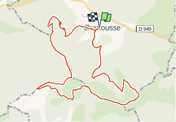
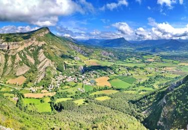
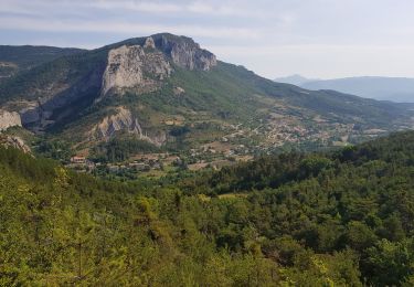
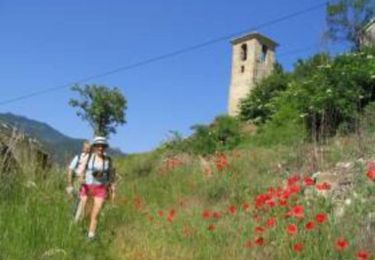
Tour Wandern von 13,6 km verfügbar auf Provence-Alpes-Côte d'Azur, Hochalpen, Chanousse. Diese Tour wird von rigol05 vorgeschlagen.
Beschreibung
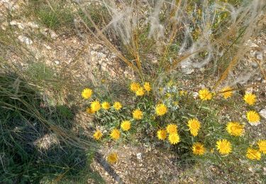
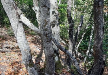
Sortie du 19/04/2018Itinéraire avec des pentes relativement raides surtout pour atteindre le sommet de la Fayée. Itinéraire peu balisé mais sur bon sentier.
Ort
Land:
France
Region :
Provence-Alpes-Côte d'Azur
Abteilung/Provinz :
Hochalpen
Kommune :
Chanousse
Standort:
Unknown
Gehen Sie:(Dec)
Gehen Sie:(UTM)
711651 ; 4914756 (31T) N.
Kommentare
Touren in der Umgebung
![Tour Mountainbike L'Épine - VTT26 - Serre Larobe - Photo](https://media.geolcdn.com/t/375/260/ext.jpg?maxdim=2&url=https%3A%2F%2Fservices.sitytrail.com%2FGeolivesWS%2FDownloadMedia.ashx%3FTrailID%3D894046%26Media%3D907c6e7e-4503-47fb-a84c-2b115673d01d.jpg)
![Mountainbike Mountainbike](https://static1.geolcdn.com/sitytour/trail-icons/202.png)
VTT26 - Serre Larobe
Mountainbike
Medium
L'Épine,
Provence-Alpes-Côte d'Azur,
Hochalpen,
France
![](/images/other/stat-length.png)
21 km | 31 km-effort
1h 57min
![](https://static1.geolcdn.com/siteimages/upload/files/16400158638029165_repeat_loop_refresh_sync_direction_icon.png)
Ja
![Tour Wandern Trescléoux - TRESCLEOUX Les granges de la montagne o s - Photo](https://media.geolcdn.com/t/375/260/d4139a1d-235b-4693-b7cd-01eb7b25235b.jpg&format=jpg&maxdim=2)
![Wandern Wandern](https://static1.geolcdn.com/sitytour/trail-icons/101.png)
TRESCLEOUX Les granges de la montagne o s
Wandern
Medium
(1)
Trescléoux,
Provence-Alpes-Côte d'Azur,
Hochalpen,
France
![](/images/other/stat-length.png)
9,5 km | 16,6 km-effort
2h 54min
![](https://static1.geolcdn.com/siteimages/upload/files/16400158638029165_repeat_loop_refresh_sync_direction_icon.png)
Ja
![Tour Wandern Orpierre - rocher st Michel - Photo](https://media.geolcdn.com/t/375/260/ext.jpg?maxdim=2&url=https%3A%2F%2Fservices.sitytrail.com%2FGeolivesWS%2FDownloadMedia.ashx%3FTrailID%3D569402%26Media%3Dfix__20160425114304.jpg)
![Wandern Wandern](https://static1.geolcdn.com/sitytour/trail-icons/101.png)
rocher st Michel
Wandern
Medium
Orpierre,
Provence-Alpes-Côte d'Azur,
Hochalpen,
France
![](/images/other/stat-length.png)
9 km | 16 km-effort
3h 41min
![](https://static1.geolcdn.com/siteimages/upload/files/16400158638029165_repeat_loop_refresh_sync_direction_icon.png)
Ja
![Tour Mountainbike Montjay - HA J1 long - Photo](https://media.geolcdn.com/t/375/260/ext.jpg?maxdim=2&url=https%3A%2F%2Fstatic1.geolcdn.com%2Fsiteimages%2Fupload%2Ffiles%2F1524743154velo.jpg)
![Mountainbike Mountainbike](https://static1.geolcdn.com/sitytour/trail-icons/202.png)
HA J1 long
Mountainbike
Sehr leicht
(3)
Montjay,
Provence-Alpes-Côte d'Azur,
Hochalpen,
France
![](/images/other/stat-length.png)
25 km | 33 km-effort
2h 7min
![](https://static1.geolcdn.com/siteimages/upload/files/16400158638029165_repeat_loop_refresh_sync_direction_icon.png)
Nein
![Tour Wandern Trescléoux - TRESCLEOUX .GRANGES DE CHANOUSSE O - Photo](https://media.geolcdn.com/t/375/260/53f4cc1e-2c32-49c3-a4d1-738f80599446.jpg&format=jpg&maxdim=2)
![Wandern Wandern](https://static1.geolcdn.com/sitytour/trail-icons/101.png)
TRESCLEOUX .GRANGES DE CHANOUSSE O
Wandern
Medium
Trescléoux,
Provence-Alpes-Côte d'Azur,
Hochalpen,
France
![](/images/other/stat-length.png)
9,7 km | 16,8 km-effort
3h 50min
![](https://static1.geolcdn.com/siteimages/upload/files/16400158638029165_repeat_loop_refresh_sync_direction_icon.png)
Ja
![Tour Wandern Orpierre - 220822 La Louze - Photo](https://media.geolcdn.com/t/375/260/43335d2e-db02-450a-80e5-5e97f05e36ca.jpg&format=jpg&maxdim=2)
![Wandern Wandern](https://static1.geolcdn.com/sitytour/trail-icons/101.png)
220822 La Louze
Wandern
Sehr schwierig
Orpierre,
Provence-Alpes-Côte d'Azur,
Hochalpen,
France
![](/images/other/stat-length.png)
12,5 km | 19,4 km-effort
2h 42min
![](https://static1.geolcdn.com/siteimages/upload/files/16400158638029165_repeat_loop_refresh_sync_direction_icon.png)
Ja
![Tour Wandern Trescléoux - Le Suillet via Le Rocher Pointu au Départ de Trescléoux - Photo](https://media.geolcdn.com/t/375/260/3a37aa31-58a7-450d-9198-e5a4a0ccf7ad.jpg&format=jpg&maxdim=2)
![Wandern Wandern](https://static1.geolcdn.com/sitytour/trail-icons/101.png)
Le Suillet via Le Rocher Pointu au Départ de Trescléoux
Wandern
Sehr schwierig
Trescléoux,
Provence-Alpes-Côte d'Azur,
Hochalpen,
France
![](/images/other/stat-length.png)
13,2 km | 25 km-effort
6h 20min
![](https://static1.geolcdn.com/siteimages/upload/files/16400158638029165_repeat_loop_refresh_sync_direction_icon.png)
Ja
![Tour Wandern Orpierre - st Michel - Photo](https://media.geolcdn.com/t/375/260/0978b7aa-47a5-4f12-859e-5d5d8fde4b1b.jpg&format=jpg&maxdim=2)
![Wandern Wandern](https://static1.geolcdn.com/sitytour/trail-icons/101.png)
st Michel
Wandern
Schwierig
Orpierre,
Provence-Alpes-Côte d'Azur,
Hochalpen,
France
![](/images/other/stat-length.png)
8,4 km | 15,1 km-effort
3h 2min
![](https://static1.geolcdn.com/siteimages/upload/files/16400158638029165_repeat_loop_refresh_sync_direction_icon.png)
Ja
![Tour Wandern Trescléoux - Tour des Baronnies du Buëch - Trescleoux - Serres - Photo](https://media.geolcdn.com/t/375/260/ext.jpg?maxdim=2&url=https%3A%2F%2Fservices.sitytrail.com%2FGeolivesWS%2FDownloadMedia.ashx%3FTrailID%3D108462%26Media%3D1174_1.jpg)
![Wandern Wandern](https://static1.geolcdn.com/sitytour/trail-icons/101.png)
Tour des Baronnies du Buëch - Trescleoux - Serres
Wandern
Schwierig
Trescléoux,
Provence-Alpes-Côte d'Azur,
Hochalpen,
France
![](/images/other/stat-length.png)
12,7 km | 25 km-effort
4h 30min
![](https://static1.geolcdn.com/siteimages/upload/files/16400158638029165_repeat_loop_refresh_sync_direction_icon.png)
Nein