![](/images/other/stat-length.png)
![Tour Wandern Nanteau-sur-Essonne - 2018-04-09 Rando Nanteau-sur-Essonne Malesherbes et la vallée de l'essonne - Photo](https://media.geolcdn.com/t/1900/400/ext.pjpeg?maxdim=2&url=https%3A%2F%2Fstatic1.geolcdn.com%2Fsiteimages%2Fupload%2Ffiles%2F1553511878bg_sport_marche.png)
2018-04-09 Rando Nanteau-sur-Essonne Malesherbes et la vallée de l'essonne
jchezlemas
Benutzer
![Länge](/images/other/stat-length.png)
Länge
14,5 km
![Maximale Höhe](https://static1.geolcdn.com/siteimages/upload/files/1508320355ic_sort_altitude_max_24dp.png)
Maximale Höhe
122 m
![Positive Höhendifferenz](https://static1.geolcdn.com/siteimages/upload/files/1508320355ic_sort_den_pos_24dp.png)
Positive Höhendifferenz
201 m
![Km-Effort](/images/other/stat-length.png)
Km-Effort
17,2 km
![Min. Höhe](https://static1.geolcdn.com/siteimages/upload/files/1508320355ic_sort_altitude_min_24dp.png)
Min. Höhe
69 m
![Negative Höhendifferenz](https://static1.geolcdn.com/siteimages/upload/files/1508320355ic_sort_den_neg_24dp.png)
Negative Höhendifferenz
204 m
![Boucle](https://static1.geolcdn.com/siteimages/upload/files/16400158638029165_repeat_loop_refresh_sync_direction_icon.png)
Boucle
Ja
Erstellungsdatum :
2018-04-18 00:03:18.758
Letzte Änderung :
2018-04-18 00:03:18.758
![Wandern](https://static1.geolcdn.com/sitytour/trail-icons/101.png)
3h42
Schwierigkeit : Einfach
![Scannen Sie diesen QR-Code, um die Tour in der SityTrail-Anwendung zu öffnen](https://capi.geolives.com/qq0zvz2zws4bq2lad0pu/sitytour/trails/939666/qr.png?size=200)
Kostenlosegpshiking-Anwendung
Über SityTrail
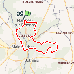
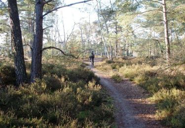
Tour Wandern von 14,5 km verfügbar auf Île-de-France, Seine-et-Marne, Nanteau-sur-Essonne. Diese Tour wird von jchezlemas vorgeschlagen.
Beschreibung
Rando de Martine et Alain Gauthier
Office de Tourisme de l'Arpajonnais
http://ot-arpajonnais.fr/
Ort
Land:
France
Region :
Île-de-France
Abteilung/Provinz :
Seine-et-Marne
Kommune :
Nanteau-sur-Essonne
Standort:
Unknown
Gehen Sie:(Dec)
Gehen Sie:(UTM)
456835 ; 5351660 (31U) N.
Kommentare
Touren in der Umgebung
![Tour Wandern Le Malesherbois - Le tour du Grand Paris via le GR1 étape 15 Malesherbes- Boutigny sur Essonne - Photo](https://media.geolcdn.com/t/375/260/4c4d5939-cd61-4041-80ce-e31b308a4e9c.jpg&format=jpg&maxdim=2)
![Wandern Wandern](https://static1.geolcdn.com/sitytour/trail-icons/101.png)
Le tour du Grand Paris via le GR1 étape 15 Malesherbes- Boutigny sur Essonne
Wandern
Einfach
Le Malesherbois,
Zentrum-Loiretal,
Loiret,
France
![](/images/other/stat-length.png)
28 km | 33 km-effort
5h 58min
![](https://static1.geolcdn.com/siteimages/upload/files/16400158638029165_repeat_loop_refresh_sync_direction_icon.png)
Nein
![Tour Wandern Buno-Bonnevaux - Buno-Bonneveaux - Polissoir de Grimery - Photo](https://media.geolcdn.com/t/375/260/fb45abfa-aec4-48f6-b6e7-2e3f4580f3ae.jpg&format=jpg&maxdim=2)
![Wandern Wandern](https://static1.geolcdn.com/sitytour/trail-icons/101.png)
Buno-Bonneveaux - Polissoir de Grimery
Wandern
Medium
Buno-Bonnevaux,
Île-de-France,
Essonne,
France
![](/images/other/stat-length.png)
7,5 km | 8,9 km-effort
2h 0min
![](https://static1.geolcdn.com/siteimages/upload/files/16400158638029165_repeat_loop_refresh_sync_direction_icon.png)
Ja
![Tour Wandern Buno-Bonnevaux - Buneau-Bonnevaux Menhir de la pierre droite - Photo](https://media.geolcdn.com/t/375/260/2f306896-f313-4a5f-a380-c29ec6b616bc.jpg&format=jpg&maxdim=2)
![Wandern Wandern](https://static1.geolcdn.com/sitytour/trail-icons/101.png)
Buneau-Bonnevaux Menhir de la pierre droite
Wandern
Einfach
Buno-Bonnevaux,
Île-de-France,
Essonne,
France
![](/images/other/stat-length.png)
12,2 km | 13,9 km-effort
3h 9min
![](https://static1.geolcdn.com/siteimages/upload/files/16400158638029165_repeat_loop_refresh_sync_direction_icon.png)
Ja
![Tour Mountainbike Buthiers - Enduro VTT de Buthiers 2006 - Photo](https://media.geolcdn.com/t/375/260/ext.jpg?maxdim=2&url=https%3A%2F%2Fservices.sitytrail.com%2FGeolivesWS%2FDownloadMedia.ashx%3FTrailID%3D101109%26Media%3D601_1.jpg)
![Mountainbike Mountainbike](https://static1.geolcdn.com/sitytour/trail-icons/202.png)
Enduro VTT de Buthiers 2006
Mountainbike
Sehr schwierig
Buthiers,
Île-de-France,
Seine-et-Marne,
France
![](/images/other/stat-length.png)
36 km | 44 km-effort
3h 0min
![](https://static1.geolcdn.com/siteimages/upload/files/16400158638029165_repeat_loop_refresh_sync_direction_icon.png)
Ja
![Tour Wandern Buno-Bonnevaux - Buno Bonnevaux 2024 - Photo](https://media.geolcdn.com/t/375/260/ext.jpg?maxdim=2&url=https%3A%2F%2Fstatic1.geolcdn.com%2Fsiteimages%2Fupload%2Ffiles%2F1553511878bg_sport_marche.png)
![Wandern Wandern](https://static1.geolcdn.com/sitytour/trail-icons/101.png)
Buno Bonnevaux 2024
Wandern
Medium
Buno-Bonnevaux,
Île-de-France,
Essonne,
France
![](/images/other/stat-length.png)
10,5 km | 11,8 km-effort
2h 41min
![](https://static1.geolcdn.com/siteimages/upload/files/16400158638029165_repeat_loop_refresh_sync_direction_icon.png)
Ja
![Tour Mountainbike Prunay-sur-Essonne - VTT 25 juin 2024 - Photo](https://media.geolcdn.com/t/375/260/ext.jpg?maxdim=2&url=https%3A%2F%2Fstatic1.geolcdn.com%2Fsiteimages%2Fupload%2Ffiles%2F1524743154velo.jpg)
![Mountainbike Mountainbike](https://static1.geolcdn.com/sitytour/trail-icons/202.png)
VTT 25 juin 2024
Mountainbike
Einfach
Prunay-sur-Essonne,
Île-de-France,
Essonne,
France
![](/images/other/stat-length.png)
13 km | 14,3 km-effort
1h 32min
![](https://static1.geolcdn.com/siteimages/upload/files/16400158638029165_repeat_loop_refresh_sync_direction_icon.png)
Ja
![Tour Kanufahren - Kajakfahren Prunay-sur-Essonne - 16 jun 2024 - Photo](https://media.geolcdn.com/t/375/260/ext.jpg?maxdim=2&url=https%3A%2F%2Fsecurestorage.geolives.com%2Fsitytour%2Ftrail-bg%2Fdefault.jpg)
![Kanufahren - Kajakfahren Kanufahren - Kajakfahren](https://static1.geolcdn.com/sitytour/trail-icons/703.png)
16 jun 2024
Kanufahren - Kajakfahren
Sehr leicht
Prunay-sur-Essonne,
Île-de-France,
Essonne,
France
![](/images/other/stat-length.png)
10,9 km | 12,1 km-effort
51min
![](https://static1.geolcdn.com/siteimages/upload/files/16400158638029165_repeat_loop_refresh_sync_direction_icon.png)
Ja
![Tour Mountainbike Prunay-sur-Essonne - 17 oct 2923 - Photo](https://media.geolcdn.com/t/375/260/3019feff-c938-49ae-abcd-cf77e0080557.jpg&format=jpg&maxdim=2)
![Mountainbike Mountainbike](https://static1.geolcdn.com/sitytour/trail-icons/202.png)
17 oct 2923
Mountainbike
Sehr leicht
Prunay-sur-Essonne,
Île-de-France,
Essonne,
France
![](/images/other/stat-length.png)
13,4 km | 15 km-effort
1h 31min
![](https://static1.geolcdn.com/siteimages/upload/files/16400158638029165_repeat_loop_refresh_sync_direction_icon.png)
Ja
![Tour Mountainbike Prunay-sur-Essonne - VTT 26 juin 2023 - Photo](https://media.geolcdn.com/t/375/260/44a7b48d-67ad-499b-8509-c4dca08ce59e.jpg&format=jpg&maxdim=2)
![Mountainbike Mountainbike](https://static1.geolcdn.com/sitytour/trail-icons/202.png)
VTT 26 juin 2023
Mountainbike
Medium
Prunay-sur-Essonne,
Île-de-France,
Essonne,
France
![](/images/other/stat-length.png)
18,9 km | 21 km-effort
2h 10min
![](https://static1.geolcdn.com/siteimages/upload/files/16400158638029165_repeat_loop_refresh_sync_direction_icon.png)
Ja