![](/images/other/stat-length.png)
![Tour Fahrrad Metz - 2018-04-08-R - Maison du vélo - Aqueduc Jouy-aux-Arches - Photo](https://media.geolcdn.com/t/1900/400/ext.pjpeg?maxdim=2&url=https%3A%2F%2Fstatic1.geolcdn.com%2Fsiteimages%2Fupload%2Ffiles%2F1524743154velo.jpg)
2018-04-08-R - Maison du vélo - Aqueduc Jouy-aux-Arches
edmondnagel
Benutzer
![Länge](/images/other/stat-length.png)
Länge
26 km
![Maximale Höhe](https://static1.geolcdn.com/siteimages/upload/files/1508320355ic_sort_altitude_max_24dp.png)
Maximale Höhe
198 m
![Positive Höhendifferenz](https://static1.geolcdn.com/siteimages/upload/files/1508320355ic_sort_den_pos_24dp.png)
Positive Höhendifferenz
183 m
![Km-Effort](/images/other/stat-length.png)
Km-Effort
28 km
![Min. Höhe](https://static1.geolcdn.com/siteimages/upload/files/1508320355ic_sort_altitude_min_24dp.png)
Min. Höhe
159 m
![Negative Höhendifferenz](https://static1.geolcdn.com/siteimages/upload/files/1508320355ic_sort_den_neg_24dp.png)
Negative Höhendifferenz
182 m
![Boucle](https://static1.geolcdn.com/siteimages/upload/files/16400158638029165_repeat_loop_refresh_sync_direction_icon.png)
Boucle
Ja
Erstellungsdatum :
2018-04-17 23:57:12.413
Letzte Änderung :
2018-04-17 23:57:12.413
![Fahrrad](https://static1.geolcdn.com/sitytour/trail-icons/200.png)
1h38
Schwierigkeit : Einfach
![Scannen Sie diesen QR-Code, um die Tour in der SityTrail-Anwendung zu öffnen](https://capi.geolives.com/qq0zvz2zws4bq2lad0pu/sitytour/trails/938873/qr.png?size=200)
Kostenlosegpshiking-Anwendung
Über SityTrail
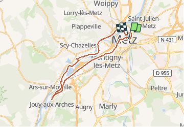
Tour Fahrrad von 26 km verfügbar auf Großer Osten, Mosel, Metz. Diese Tour wird von edmondnagel vorgeschlagen.
Beschreibung
Départ Maison du vélo - Aqueduc Jouy-aux-Arches par les remparts, Pontiffroy, pour rejoindre le véloroute Charles Le Téméraire, jusqu'à l'aqueduc de Jouy-aux-Arches, puis retour par le canal de Jouy, allée du Bras Mort, Cathédrale, Eglise Sainte Ségolène, Maison du Vélo
Ort
Land:
France
Region :
Großer Osten
Abteilung/Provinz :
Mosel
Kommune :
Metz
Standort:
Unknown
Gehen Sie:(Dec)
Gehen Sie:(UTM)
294421 ; 5444592 (32U) N.
Kommentare
Touren in der Umgebung
![Tour Wandern Papolsheim - Saint Quentin - Photo](https://media.geolcdn.com/t/375/260/ext.jpg?maxdim=2&url=https%3A%2F%2Fservices.sitytrail.com%2FGeolivesWS%2FDownloadMedia.ashx%3FTrailID%3D159776%26Media%3D20121024120133.jpg)
![Wandern Wandern](https://static1.geolcdn.com/sitytour/trail-icons/101.png)
Saint Quentin
Wandern
Medium
(1)
Papolsheim,
Großer Osten,
Mosel,
France
![](/images/other/stat-length.png)
6,9 km | 9,2 km-effort
1h 59min
![](https://static1.geolcdn.com/siteimages/upload/files/16400158638029165_repeat_loop_refresh_sync_direction_icon.png)
Ja
![Tour Wandern Papolsheim - Autour du fort de Plappeville. - Photo](https://media.geolcdn.com/t/375/260/ext.jpg?maxdim=2&url=https%3A%2F%2Fservices.sitytrail.com%2FGeolivesWS%2FDownloadMedia.ashx%3FTrailID%3D147559%26Media%3D20120816102740.jpg)
![Wandern Wandern](https://static1.geolcdn.com/sitytour/trail-icons/101.png)
Autour du fort de Plappeville.
Wandern
Einfach
(1)
Papolsheim,
Großer Osten,
Mosel,
France
![](/images/other/stat-length.png)
8,9 km | 11 km-effort
2h 55min
![](https://static1.geolcdn.com/siteimages/upload/files/16400158638029165_repeat_loop_refresh_sync_direction_icon.png)
Ja
![Tour Zu Fuß Metz - Circuit des sentiers de Queuleu - Photo](https://media.geolcdn.com/t/375/260/e8f5cc79-0435-4c0e-abc8-879d05da612b.jpeg&format=jpg&maxdim=2)
![Zu Fuß Zu Fuß](https://static1.geolcdn.com/sitytour/trail-icons/100.png)
Circuit des sentiers de Queuleu
Zu Fuß
Einfach
Metz,
Großer Osten,
Mosel,
France
![](/images/other/stat-length.png)
4,5 km | 5,2 km-effort
1h 10min
![](https://static1.geolcdn.com/siteimages/upload/files/16400158638029165_repeat_loop_refresh_sync_direction_icon.png)
Ja
![Tour Zu Fuß Scy-Chazelles - Circuit du Tour du Mont St Quentin - Photo](https://media.geolcdn.com/t/375/260/0227a6bb-ecc7-41f2-b92a-b603e3858c5b.jpeg&format=jpg&maxdim=2)
![Zu Fuß Zu Fuß](https://static1.geolcdn.com/sitytour/trail-icons/100.png)
Circuit du Tour du Mont St Quentin
Zu Fuß
Einfach
Scy-Chazelles,
Großer Osten,
Mosel,
France
![](/images/other/stat-length.png)
4,9 km | 6,7 km-effort
1h 31min
![](https://static1.geolcdn.com/siteimages/upload/files/16400158638029165_repeat_loop_refresh_sync_direction_icon.png)
Nein
![Wandern Wandern](https://static1.geolcdn.com/sitytour/trail-icons/101.png)
20210723 - METZ - Promenade des remparts - 6 Km
Wandern
Sehr leicht
Metz,
Großer Osten,
Mosel,
France
![](/images/other/stat-length.png)
5,7 km | 6,6 km-effort
1h 45min
![](https://static1.geolcdn.com/siteimages/upload/files/16400158638029165_repeat_loop_refresh_sync_direction_icon.png)
Ja
![Tour Mountainbike Metz - MetzGare-PAM - Photo](https://media.geolcdn.com/t/375/260/ext.jpg?maxdim=2&url=https%3A%2F%2Fstatic1.geolcdn.com%2Fsiteimages%2Fupload%2Ffiles%2F1524743154velo.jpg)
![Mountainbike Mountainbike](https://static1.geolcdn.com/sitytour/trail-icons/202.png)
MetzGare-PAM
Mountainbike
Einfach
(1)
Metz,
Großer Osten,
Mosel,
France
![](/images/other/stat-length.png)
30 km | 33 km-effort
Unbekannt
![](https://static1.geolcdn.com/siteimages/upload/files/16400158638029165_repeat_loop_refresh_sync_direction_icon.png)
Nein
![Tour Wandern Longeville-lès-Metz - Metz - Les fortifications & 🎅🎄 - Photo](https://media.geolcdn.com/t/375/260/78c4f220-2684-42e2-8e51-0cc7754dd491.jpg&format=jpg&maxdim=2)
![Wandern Wandern](https://static1.geolcdn.com/sitytour/trail-icons/101.png)
Metz - Les fortifications & 🎅🎄
Wandern
Einfach
Longeville-lès-Metz,
Großer Osten,
Mosel,
France
![](/images/other/stat-length.png)
11,2 km | 12,9 km-effort
2h 41min
![](https://static1.geolcdn.com/siteimages/upload/files/16400158638029165_repeat_loop_refresh_sync_direction_icon.png)
Ja
![Tour Wandern Longeville-lès-Metz - 🎅🎄 Noël à Metz - Photo](https://media.geolcdn.com/t/375/260/5af36f19-04a2-474a-9a82-8a9aed35e003.jpg&format=jpg&maxdim=2)
![Wandern Wandern](https://static1.geolcdn.com/sitytour/trail-icons/101.png)
🎅🎄 Noël à Metz
Wandern
Einfach
Longeville-lès-Metz,
Großer Osten,
Mosel,
France
![](/images/other/stat-length.png)
14,5 km | 16,5 km-effort
3h 54min
![](https://static1.geolcdn.com/siteimages/upload/files/16400158638029165_repeat_loop_refresh_sync_direction_icon.png)
Ja
![Tour Pferd Wappingen - Vers chez Sam - Photo](https://media.geolcdn.com/t/375/260/ext.jpg?maxdim=2&url=https%3A%2F%2Fstatic1.geolcdn.com%2Fsiteimages%2Fupload%2Ffiles%2F1524743154cheval.jpg)
![Pferd Pferd](https://static1.geolcdn.com/sitytour/trail-icons/300.png)
Vers chez Sam
Pferd
Sehr leicht
(1)
Wappingen,
Großer Osten,
Mosel,
France
![](/images/other/stat-length.png)
9,3 km | 12,3 km-effort
Unbekannt
![](https://static1.geolcdn.com/siteimages/upload/files/16400158638029165_repeat_loop_refresh_sync_direction_icon.png)
Nein