![](/images/other/stat-length.png)
![Tour Wandern Dehlingen - Sur les pas des Romains... - Photo](https://media.geolcdn.com/t/1900/400/ext.pjpeg?maxdim=2&url=https%3A%2F%2Fservices.sitytrail.com%2FGeolivesWS%2FDownloadMedia.ashx%3FTrailID%3D924479%26Media%3Dfix__20180223142709.jpg)
Sur les pas des Romains...
helmut68
Benutzer
![Länge](/images/other/stat-length.png)
![Maximale Höhe](https://static1.geolcdn.com/siteimages/upload/files/1508320355ic_sort_altitude_max_24dp.png)
![Positive Höhendifferenz](https://static1.geolcdn.com/siteimages/upload/files/1508320355ic_sort_den_pos_24dp.png)
![Km-Effort](/images/other/stat-length.png)
![Min. Höhe](https://static1.geolcdn.com/siteimages/upload/files/1508320355ic_sort_altitude_min_24dp.png)
![Negative Höhendifferenz](https://static1.geolcdn.com/siteimages/upload/files/1508320355ic_sort_den_neg_24dp.png)
![Boucle](https://static1.geolcdn.com/siteimages/upload/files/16400158638029165_repeat_loop_refresh_sync_direction_icon.png)
![Wandern](https://static1.geolcdn.com/sitytour/trail-icons/101.png)
3h15
Schwierigkeit : Einfach
![Scannen Sie diesen QR-Code, um die Tour in der SityTrail-Anwendung zu öffnen](https://capi.geolives.com/qq0zvz2zws4bq2lad0pu/sitytour/trails/924479/qr.png?size=200)
Kostenlosegpshiking-Anwendung
Über SityTrail
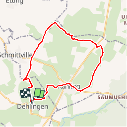
Tour Wandern von 15,2 km verfügbar auf Großer Osten, Unterelsass, Dehlingen. Diese Tour wird von helmut68 vorgeschlagen.
Beschreibung
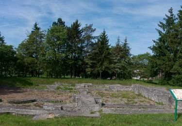
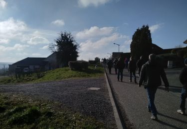
Départ à la fontaine de Dehlingen, emprunter la voie romaine jusqu'au château d'eau de Schmittwiller,poursuivez le chemin jusqu'à la chappelle d'Altkirch,puis rejoignez ensuite celle de Saint Wendelin( Weiherkirche), continuez jusqu'à Rahling pour rejoindre Dehlingen par le site archéologique du Gurtelbach.
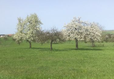
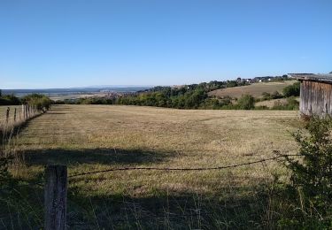
Parcours qui peut se faire par temps sec en baskets. Des vues magnifiques sur l'Alsace bossue et la Lorraine ( 365 degrés par temps clair)
Ort
Kommentare
Touren in der Umgebung
![Tour Zu Fuß Diemeringen - Mackwiller la romaine - Photo](https://media.geolcdn.com/t/375/260/6e42945c-7f24-4443-aff5-37264c5394f0.jpeg&format=jpg&maxdim=2)
![Zu Fuß Zu Fuß](https://static1.geolcdn.com/sitytour/trail-icons/100.png)
Zu Fuß
![](/images/other/stat-length.png)
![](https://static1.geolcdn.com/siteimages/upload/files/16400158638029165_repeat_loop_refresh_sync_direction_icon.png)
![Tour Zu Fuß Diemeringen - Croix bleue - Photo](https://media.geolcdn.com/t/375/260/038b5fbd-ad7d-4d8f-a6b9-4f60e8eebeb8.jpeg&format=jpg&maxdim=2)
![Zu Fuß Zu Fuß](https://static1.geolcdn.com/sitytour/trail-icons/100.png)
Zu Fuß
![](/images/other/stat-length.png)
![](https://static1.geolcdn.com/siteimages/upload/files/16400158638029165_repeat_loop_refresh_sync_direction_icon.png)
![Tour Zu Fuß Diemeringen - Triangle bleu - Photo](https://media.geolcdn.com/t/375/260/d4b9e7be-1430-47f3-af7c-96cdacf9298e.jpeg&format=jpg&maxdim=2)
![Zu Fuß Zu Fuß](https://static1.geolcdn.com/sitytour/trail-icons/100.png)
Zu Fuß
![](/images/other/stat-length.png)
![](https://static1.geolcdn.com/siteimages/upload/files/16400158638029165_repeat_loop_refresh_sync_direction_icon.png)
![Tour Zu Fuß Diemeringen - Comtesse Sophie de Nassau - Photo](https://media.geolcdn.com/t/375/260/8c2b8556-e0a8-4065-811c-0a8a71e07fa2.jpeg&format=jpg&maxdim=2)
![Zu Fuß Zu Fuß](https://static1.geolcdn.com/sitytour/trail-icons/100.png)
Zu Fuß
![](/images/other/stat-length.png)
![](https://static1.geolcdn.com/siteimages/upload/files/16400158638029165_repeat_loop_refresh_sync_direction_icon.png)
![Tour Zu Fuß Diemeringen - Gelbes Dreieck - Photo](https://media.geolcdn.com/t/375/260/d4b9e7be-1430-47f3-af7c-96cdacf9298e.jpeg&format=jpg&maxdim=2)
![Zu Fuß Zu Fuß](https://static1.geolcdn.com/sitytour/trail-icons/100.png)
Zu Fuß
![](/images/other/stat-length.png)
![](https://static1.geolcdn.com/siteimages/upload/files/16400158638029165_repeat_loop_refresh_sync_direction_icon.png)
![Tour sport Butten - 2024-04-07 Les vergers de Butten - Photo](https://media.geolcdn.com/t/375/260/21e8b322-75c7-495e-aaf5-acea1f138e8c.jpg&format=jpg&maxdim=2)
sport
![](/images/other/stat-length.png)
![](https://static1.geolcdn.com/siteimages/upload/files/16400158638029165_repeat_loop_refresh_sync_direction_icon.png)
![Tour Wandern Dehlingen - Speckfest Dehlingen 2023 - Photo](https://media.geolcdn.com/t/375/260/50343618-1039-4cc2-8cba-88bb57992e6e.jpg&format=jpg&maxdim=2)
![Wandern Wandern](https://static1.geolcdn.com/sitytour/trail-icons/101.png)
Wandern
![](/images/other/stat-length.png)
![](https://static1.geolcdn.com/siteimages/upload/files/16400158638029165_repeat_loop_refresh_sync_direction_icon.png)
![Tour Zu Fuß Ratzweiler - Chevalet vert - Photo](https://media.geolcdn.com/t/375/260/e1ca6c5c-ec16-4e6c-a9bf-b3aef84f04a4.jpeg&format=jpg&maxdim=2)
![Zu Fuß Zu Fuß](https://static1.geolcdn.com/sitytour/trail-icons/100.png)
Zu Fuß
![](/images/other/stat-length.png)
![](https://static1.geolcdn.com/siteimages/upload/files/16400158638029165_repeat_loop_refresh_sync_direction_icon.png)
![Tour Wandern Dehlingen - Dehlingen Remelfing - Photo](https://media.geolcdn.com/t/375/260/4e1a1449-9bb3-41eb-9ea3-e127d0b3e233.jpg&format=jpg&maxdim=2)
![Wandern Wandern](https://static1.geolcdn.com/sitytour/trail-icons/101.png)
Wandern
![](/images/other/stat-length.png)
![](https://static1.geolcdn.com/siteimages/upload/files/16400158638029165_repeat_loop_refresh_sync_direction_icon.png)