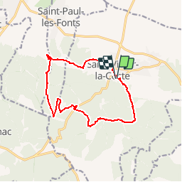
![](/images/other/stat-length.png)
![Tour Wandern Saint-Victor-la-Coste - Le Goule de Navet - St Victor la Coste - Photo](https://media.geolcdn.com/t/1900/400/ext.pjpeg?maxdim=2&url=https%3A%2F%2Fstatic1.geolcdn.com%2Fsiteimages%2Fupload%2Ffiles%2F1553511878bg_sport_marche.png)
Le Goule de Navet - St Victor la Coste
rysma
Benutzer
![Länge](/images/other/stat-length.png)
![Maximale Höhe](https://static1.geolcdn.com/siteimages/upload/files/1508320355ic_sort_altitude_max_24dp.png)
![Positive Höhendifferenz](https://static1.geolcdn.com/siteimages/upload/files/1508320355ic_sort_den_pos_24dp.png)
![Km-Effort](/images/other/stat-length.png)
![Min. Höhe](https://static1.geolcdn.com/siteimages/upload/files/1508320355ic_sort_altitude_min_24dp.png)
![Negative Höhendifferenz](https://static1.geolcdn.com/siteimages/upload/files/1508320355ic_sort_den_neg_24dp.png)
![Boucle](https://static1.geolcdn.com/siteimages/upload/files/16400158638029165_repeat_loop_refresh_sync_direction_icon.png)
![Wandern](https://static1.geolcdn.com/sitytour/trail-icons/101.png)
4h00
Schwierigkeit : Schwierig
![Scannen Sie diesen QR-Code, um die Tour in der SityTrail-Anwendung zu öffnen](https://capi.geolives.com/qq0zvz2zws4bq2lad0pu/sitytour/trails/921478/qr.png?size=200)
Kostenlosegpshiking-Anwendung
Über SityTrail
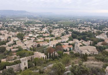
Tour Wandern von 13,7 km verfügbar auf Okzitanien, Gard, Saint-Victor-la-Coste. Diese Tour wird von rysma vorgeschlagen.
Beschreibung
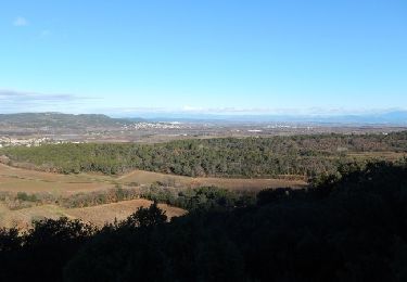
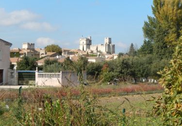
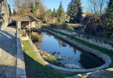
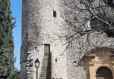
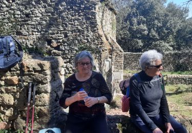
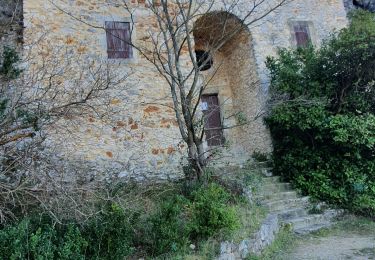
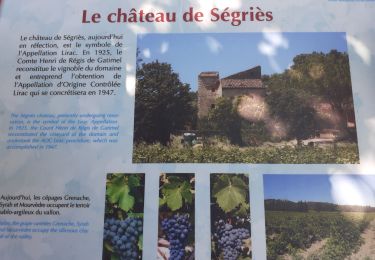
Circuit utilisant l'ancienne voie romaine qui traverse la montagne au Goule de Navet. Du parking de l'église, descendre les escaliers jusqu'à la place et prendre la rue de Plaineautier et la rue de la Combe à droite et à gauche rue de Font Crotade (panneau et balisage). La forêt se dispute l'espace avec les vignes. Traverser la colline avec la voie romaine et monter dans la forêt de pins jusqu'à la ligne HT, faire l'aller-retour pour voir le point de vue. Enfiler la laie forestière puis arriver à la route et la prendre à droite puis à gauche après la ruine. Remonter pour dominer le paysage puis emprunter la descente qui est raide. Sur des bons chemins, retourner à St-Victor. Visite possible du château. Bonne balade.
Ort
Kommentare
Touren in der Umgebung
![Tour Wandern Pouzilhac - Le sentier botanique - Pouzilhac - Photo](https://media.geolcdn.com/t/375/260/ext.jpg?maxdim=2&url=https%3A%2F%2Fservices.sitytrail.com%2FGeolivesWS%2FDownloadMedia.ashx%3FTrailID%3D317463%26Media%3D16695_6.jpg)
![Wandern Wandern](https://static1.geolcdn.com/sitytour/trail-icons/101.png)
Wandern
![](/images/other/stat-length.png)
![](https://static1.geolcdn.com/siteimages/upload/files/16400158638029165_repeat_loop_refresh_sync_direction_icon.png)
![Tour Wandern Saint-Laurent-des-Arbres - Les Vignobles de Lirac - Saint Laurent des Arbres - Photo](https://media.geolcdn.com/t/375/260/ext.jpg?maxdim=2&url=https%3A%2F%2Fservices.sitytrail.com%2FGeolivesWS%2FDownloadMedia.ashx%3FTrailID%3D317237%26Media%3D16416_6.jpg)
![Wandern Wandern](https://static1.geolcdn.com/sitytour/trail-icons/101.png)
Wandern
![](/images/other/stat-length.png)
![](https://static1.geolcdn.com/siteimages/upload/files/16400158638029165_repeat_loop_refresh_sync_direction_icon.png)
![Tour Wandern Lirac - rando des 4 lavoirs - Photo](https://media.geolcdn.com/t/375/260/b910313b-f40e-420b-9ddd-36236b127dfb.jpg&format=jpg&maxdim=2)
![Wandern Wandern](https://static1.geolcdn.com/sitytour/trail-icons/101.png)
![Tour Wandern Tresques - Autour de Tresques - Photo](https://media.geolcdn.com/t/375/260/ext.jpg?maxdim=2&url=https%3A%2F%2Fstatic1.geolcdn.com%2Fsiteimages%2Fupload%2Ffiles%2F1553511878bg_sport_marche.png)
![Wandern Wandern](https://static1.geolcdn.com/sitytour/trail-icons/101.png)
Wandern
![](/images/other/stat-length.png)
![](https://static1.geolcdn.com/siteimages/upload/files/16400158638029165_repeat_loop_refresh_sync_direction_icon.png)
![Tour Wandern Saint-Victor-la-Coste - Saint victor la coste 300323 - Photo](https://media.geolcdn.com/t/375/260/b12b695c-7275-4742-bf11-008804646dd6.jpg&format=jpg&maxdim=2)
![Wandern Wandern](https://static1.geolcdn.com/sitytour/trail-icons/101.png)
Wandern
![](/images/other/stat-length.png)
![](https://static1.geolcdn.com/siteimages/upload/files/16400158638029165_repeat_loop_refresh_sync_direction_icon.png)
![Tour Wandern Gaujac - Gaujac 160323 - Photo](https://media.geolcdn.com/t/375/260/439ce872-f270-4bfe-a0e1-c0bcc7ef5229.jpg&format=jpg&maxdim=2)
![Wandern Wandern](https://static1.geolcdn.com/sitytour/trail-icons/101.png)
![Tour Wandern Lirac - Le Tanargue - Photo](https://media.geolcdn.com/t/375/260/c76d9f19-ee2b-4749-87df-9221a92da648.jpg&format=jpg&maxdim=2)
![Wandern Wandern](https://static1.geolcdn.com/sitytour/trail-icons/101.png)
![Tour Wandern Saint-Victor-la-Coste - St Victor la Coste Goule de Navet - Photo](https://media.geolcdn.com/t/375/260/4895cb47-8177-4f48-bef5-74ca2af99397.jpg&format=jpg&maxdim=2)
![Wandern Wandern](https://static1.geolcdn.com/sitytour/trail-icons/101.png)
Wandern
![](/images/other/stat-length.png)
![](https://static1.geolcdn.com/siteimages/upload/files/16400158638029165_repeat_loop_refresh_sync_direction_icon.png)
![Tour Wandern Saint-Laurent-des-Arbres - St Laurent des Arbres Montagne St Genies - Photo](https://media.geolcdn.com/t/375/260/87789e4e-a0b1-4843-8d74-95689b72d29e.jpg&format=jpg&maxdim=2)
![Wandern Wandern](https://static1.geolcdn.com/sitytour/trail-icons/101.png)
Wandern
![](/images/other/stat-length.png)
![](https://static1.geolcdn.com/siteimages/upload/files/16400158638029165_repeat_loop_refresh_sync_direction_icon.png)