![](/images/other/stat-length.png)
![Tour Mountainbike Cherbourg-en-Cotentin - Ravalet anse du Brick - Photo](https://media.geolcdn.com/t/1900/400/ext.pjpeg?maxdim=2&url=https%3A%2F%2Fstatic1.geolcdn.com%2Fsiteimages%2Fupload%2Ffiles%2F1524743154velo.jpg)
Ravalet anse du Brick
ves
Benutzer
![Länge](/images/other/stat-length.png)
Länge
46 km
![Maximale Höhe](https://static1.geolcdn.com/siteimages/upload/files/1508320355ic_sort_altitude_max_24dp.png)
Maximale Höhe
149 m
![Positive Höhendifferenz](https://static1.geolcdn.com/siteimages/upload/files/1508320355ic_sort_den_pos_24dp.png)
Positive Höhendifferenz
632 m
![Km-Effort](/images/other/stat-length.png)
Km-Effort
55 km
![Min. Höhe](https://static1.geolcdn.com/siteimages/upload/files/1508320355ic_sort_altitude_min_24dp.png)
Min. Höhe
-1 m
![Negative Höhendifferenz](https://static1.geolcdn.com/siteimages/upload/files/1508320355ic_sort_den_neg_24dp.png)
Negative Höhendifferenz
651 m
![Boucle](https://static1.geolcdn.com/siteimages/upload/files/16400158638029165_repeat_loop_refresh_sync_direction_icon.png)
Boucle
Nein
Erstellungsdatum :
2018-04-17 21:13:26.127
Letzte Änderung :
2018-04-17 21:13:26.127
![Mountainbike](https://static1.geolcdn.com/sitytour/trail-icons/202.png)
3h58
Schwierigkeit : Medium
![Scannen Sie diesen QR-Code, um die Tour in der SityTrail-Anwendung zu öffnen](https://capi.geolives.com/qq0zvz2zws4bq2lad0pu/sitytour/trails/919461/qr.png?size=200)
Kostenlosegpshiking-Anwendung
Über SityTrail
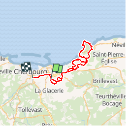
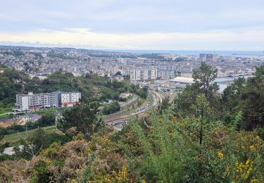
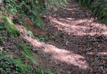
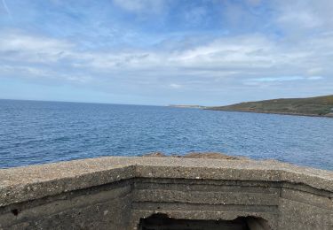
Tour Mountainbike von 46 km verfügbar auf Normandie, Manche, Cherbourg-en-Cotentin. Diese Tour wird von ves vorgeschlagen.
Beschreibung
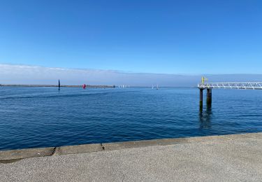
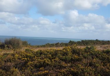
Petit tour avec le club des Haguards en partant du château des Ravalet sur des chemins roulants vers l'anse du Brick puis le littoral sous cette belle lumière...
Ort
Land:
France
Region :
Normandie
Abteilung/Provinz :
Manche
Kommune :
Cherbourg-en-Cotentin
Standort:
Tourlaville
Gehen Sie:(Dec)
Gehen Sie:(UTM)
603475 ; 5498307 (30U) N.
Kommentare
Touren in der Umgebung
![Tour Zu Fuß Cherbourg-en-Cotentin - Séjour Cotentin Etape 7 Boucle Cherbourg avant départ - Photo](https://media.geolcdn.com/t/375/260/ecdd6e0d-0f77-43a1-9488-9c5e48720411.jpg&format=jpg&maxdim=2)
![Zu Fuß Zu Fuß](https://static1.geolcdn.com/sitytour/trail-icons/100.png)
Séjour Cotentin Etape 7 Boucle Cherbourg avant départ
Zu Fuß
Einfach
Cherbourg-en-Cotentin,
Normandie,
Manche,
France
![](/images/other/stat-length.png)
12,2 km | 14,9 km-effort
3h 22min
![](https://static1.geolcdn.com/siteimages/upload/files/16400158638029165_repeat_loop_refresh_sync_direction_icon.png)
Nein
![Tour Wandern Cherbourg-en-Cotentin - La Glacerie - Photo](https://media.geolcdn.com/t/375/260/d538c617-51e8-4dc1-9179-9dd9282dc35e.jpg&format=jpg&maxdim=2)
![Wandern Wandern](https://static1.geolcdn.com/sitytour/trail-icons/101.png)
La Glacerie
Wandern
Einfach
Cherbourg-en-Cotentin,
Normandie,
Manche,
France
![](/images/other/stat-length.png)
6,6 km | 8,7 km-effort
1h 26min
![](https://static1.geolcdn.com/siteimages/upload/files/16400158638029165_repeat_loop_refresh_sync_direction_icon.png)
Ja
![Tour Wandern Bretteville - Bretteville Pointe de la Bricq - Photo](https://media.geolcdn.com/t/375/260/209219c0-94e3-47ef-bd3d-ccc00af85e15.jpg&format=jpg&maxdim=2)
![Wandern Wandern](https://static1.geolcdn.com/sitytour/trail-icons/101.png)
Bretteville Pointe de la Bricq
Wandern
Bretteville,
Normandie,
Manche,
France
![](/images/other/stat-length.png)
7,3 km | 8,3 km-effort
2h 19min
![](https://static1.geolcdn.com/siteimages/upload/files/16400158638029165_repeat_loop_refresh_sync_direction_icon.png)
Ja
![Tour Rennrad Cherbourg-en-Cotentin - Autour de Cherbourg en vélo - Photo](https://media.geolcdn.com/t/375/260/e98822be-3a7d-4320-ad41-408bde740599.jpg&format=jpg&maxdim=2)
![Rennrad Rennrad](https://static1.geolcdn.com/sitytour/trail-icons/201.png)
Autour de Cherbourg en vélo
Rennrad
Sehr leicht
Cherbourg-en-Cotentin,
Normandie,
Manche,
France
![](/images/other/stat-length.png)
24 km | 26 km-effort
2h 12min
![](https://static1.geolcdn.com/siteimages/upload/files/16400158638029165_repeat_loop_refresh_sync_direction_icon.png)
Ja
![Tour Wandern Cherbourg-en-Cotentin - Tourlaville : 22 octobre 2017 - Photo](https://media.geolcdn.com/t/375/260/ext.jpg?maxdim=2&url=https%3A%2F%2Fservices.sitytrail.com%2FGeolivesWS%2FDownloadMedia.ashx%3FTrailID%3D849892%26Media%3Dfix__20171022112721.jpg)
![Wandern Wandern](https://static1.geolcdn.com/sitytour/trail-icons/101.png)
Tourlaville : 22 octobre 2017
Wandern
Einfach
Cherbourg-en-Cotentin,
Normandie,
Manche,
France
![](/images/other/stat-length.png)
6,2 km | 7,5 km-effort
1h 2min
![](https://static1.geolcdn.com/siteimages/upload/files/16400158638029165_repeat_loop_refresh_sync_direction_icon.png)
Ja
![Tour Mountainbike Cherbourg-en-Cotentin - Relais des 4 châteaux 2013 - Tourlaville - Photo](https://media.geolcdn.com/t/375/260/ext.jpg?maxdim=2&url=https%3A%2F%2Fservices.sitytrail.com%2FGeolivesWS%2FDownloadMedia.ashx%3FTrailID%3D191595%26Media%3D15228_3.jpg)
![Mountainbike Mountainbike](https://static1.geolcdn.com/sitytour/trail-icons/202.png)
Relais des 4 châteaux 2013 - Tourlaville
Mountainbike
Schwierig
Cherbourg-en-Cotentin,
Normandie,
Manche,
France
![](/images/other/stat-length.png)
30 km | 38 km-effort
3h 0min
![](https://static1.geolcdn.com/siteimages/upload/files/16400158638029165_repeat_loop_refresh_sync_direction_icon.png)
Ja
![Tour Wandern Cherbourg-en-Cotentin - Le colignon - Photo](https://media.geolcdn.com/t/375/260/ext.jpg?maxdim=2&url=https%3A%2F%2Fstatic1.geolcdn.com%2Fsiteimages%2Fupload%2Ffiles%2F1553511878bg_sport_marche.png)
![Wandern Wandern](https://static1.geolcdn.com/sitytour/trail-icons/101.png)
Le colignon
Wandern
Sehr leicht
(1)
Cherbourg-en-Cotentin,
Normandie,
Manche,
France
![](/images/other/stat-length.png)
5,8 km | 7,2 km-effort
1h 34min
![](https://static1.geolcdn.com/siteimages/upload/files/16400158638029165_repeat_loop_refresh_sync_direction_icon.png)
Ja
![Tour Wandern Cherbourg-en-Cotentin - Les chemins de Saint- Michel - Cherbourg - Lessay - Photo](https://media.geolcdn.com/t/375/260/ext.jpg?maxdim=2&url=https%3A%2F%2Fservices.sitytrail.com%2FGeolivesWS%2FDownloadMedia.ashx%3FTrailID%3D112747%26Media%3D11878_6.jpg)
![Wandern Wandern](https://static1.geolcdn.com/sitytour/trail-icons/101.png)
Les chemins de Saint- Michel - Cherbourg - Lessay
Wandern
Medium
Cherbourg-en-Cotentin,
Normandie,
Manche,
France
![](/images/other/stat-length.png)
91 km | 103 km-effort
Unbekannt
![](https://static1.geolcdn.com/siteimages/upload/files/16400158638029165_repeat_loop_refresh_sync_direction_icon.png)
Nein
![Tour Wandern Cherbourg-en-Cotentin - GR 223 - de Cherbourg à Flamanville - Photo](https://media.geolcdn.com/t/375/260/ext.jpg?maxdim=2&url=https%3A%2F%2Fstatic1.geolcdn.com%2Fsiteimages%2Fupload%2Ffiles%2F1553511878bg_sport_marche.png)
![Wandern Wandern](https://static1.geolcdn.com/sitytour/trail-icons/101.png)
GR 223 - de Cherbourg à Flamanville
Wandern
Medium
(1)
Cherbourg-en-Cotentin,
Normandie,
Manche,
France
![](/images/other/stat-length.png)
70 km | 87 km-effort
16h 0min
![](https://static1.geolcdn.com/siteimages/upload/files/16400158638029165_repeat_loop_refresh_sync_direction_icon.png)
Nein