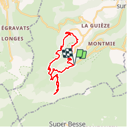
![](/images/other/stat-length.png)
![Tour Schneeschuhwandern Chambon-sur-Lac - Chaudefour - Puy de Champgourdeix Chambon des Neiges - Photo](https://media.geolcdn.com/t/1900/400/ext.pjpeg?maxdim=2&url=https%3A%2F%2Fstatic1.geolcdn.com%2Fsiteimages%2Fupload%2Ffiles%2F1524743153raquette.jpg)
Chaudefour - Puy de Champgourdeix Chambon des Neiges
olibreizh
Benutzer
![Länge](/images/other/stat-length.png)
![Maximale Höhe](https://static1.geolcdn.com/siteimages/upload/files/1508320355ic_sort_altitude_max_24dp.png)
![Positive Höhendifferenz](https://static1.geolcdn.com/siteimages/upload/files/1508320355ic_sort_den_pos_24dp.png)
![Km-Effort](/images/other/stat-length.png)
![Min. Höhe](https://static1.geolcdn.com/siteimages/upload/files/1508320355ic_sort_altitude_min_24dp.png)
![Negative Höhendifferenz](https://static1.geolcdn.com/siteimages/upload/files/1508320355ic_sort_den_neg_24dp.png)
![Boucle](https://static1.geolcdn.com/siteimages/upload/files/16400158638029165_repeat_loop_refresh_sync_direction_icon.png)
![Schneeschuhwandern](https://static1.geolcdn.com/sitytour/trail-icons/504.png)
4h51
Schwierigkeit : Schwierig
![Scannen Sie diesen QR-Code, um die Tour in der SityTrail-Anwendung zu öffnen](https://capi.geolives.com/qq0zvz2zws4bq2lad0pu/sitytour/trails/918237/qr.png?size=200)
Kostenlosegpshiking-Anwendung
Über SityTrail
Tour Schneeschuhwandern von 15 km verfügbar auf Auvergne-Rhone-Alpen, Puy-de-Dôme, Chambon-sur-Lac. Diese Tour wird von olibreizh vorgeschlagen.
Beschreibung
Tour en raquettes et à pieds au départ de la Maison de la réserve Naturelle du Chaudefour. Départ en fond de Vallée puis ascension du Puy de Champgourdeix par la Rondaire. Retour par la même voie et direction Chambon des neiges par les rochers de l'Audiouze (passage difficile en raquettes). Retour en contournant le Puy Jumel
Ort
Kommentare
Touren in der Umgebung
![Tour Wandern Mont-Dore - Montée au sommet du Puy de Sancy - Photo](https://media.geolcdn.com/t/375/260/1486ae36-afa6-41d3-a8cf-03841ddf3ad3.jpg&format=jpg&maxdim=2)
![Wandern Wandern](https://static1.geolcdn.com/sitytour/trail-icons/101.png)
Wandern
![](/images/other/stat-length.png)
![](https://static1.geolcdn.com/siteimages/upload/files/16400158638029165_repeat_loop_refresh_sync_direction_icon.png)
![Tour Wandern Chambon-sur-Lac - Chambon_Couze_Surains - Photo](https://media.geolcdn.com/t/375/260/69ddf9d1-6553-4ac4-9be3-6827620eb27f.jpg&format=jpg&maxdim=2)
![Wandern Wandern](https://static1.geolcdn.com/sitytour/trail-icons/101.png)
Wandern
![](/images/other/stat-length.png)
![](https://static1.geolcdn.com/siteimages/upload/files/16400158638029165_repeat_loop_refresh_sync_direction_icon.png)
![Wandern Wandern](https://static1.geolcdn.com/sitytour/trail-icons/101.png)
Wandern
![](/images/other/stat-length.png)
![](https://static1.geolcdn.com/siteimages/upload/files/16400158638029165_repeat_loop_refresh_sync_direction_icon.png)
![Tour Wandern Besse-et-Saint-Anastaise - Sancy par Super-Besse - Photo](https://media.geolcdn.com/t/375/260/ext.jpg?maxdim=2&url=https%3A%2F%2Fservices.sitytrail.com%2FGeolivesWS%2FDownloadMedia.ashx%3FTrailID%3D317232%26Media%3D16410_6.jpg)
![Wandern Wandern](https://static1.geolcdn.com/sitytour/trail-icons/101.png)
Wandern
![](/images/other/stat-length.png)
![](https://static1.geolcdn.com/siteimages/upload/files/16400158638029165_repeat_loop_refresh_sync_direction_icon.png)
![Tour Wandern Besse-et-Saint-Anastaise - Lac_Pavin_Montchal - Photo](https://media.geolcdn.com/t/375/260/0a17a073-6f46-4dad-9995-801fb5c96c4d.jpg&format=jpg&maxdim=2)
![Wandern Wandern](https://static1.geolcdn.com/sitytour/trail-icons/101.png)
Wandern
![](/images/other/stat-length.png)
![](https://static1.geolcdn.com/siteimages/upload/files/16400158638029165_repeat_loop_refresh_sync_direction_icon.png)
![Tour Wandern Besse-et-Saint-Anastaise - Les 3 lacs et la cascade - Photo](https://media.geolcdn.com/t/375/260/50f54827-36a7-4b68-99c1-d5774caacba8.jpg&format=jpg&maxdim=2)
![Wandern Wandern](https://static1.geolcdn.com/sitytour/trail-icons/101.png)
Wandern
![](/images/other/stat-length.png)
![](https://static1.geolcdn.com/siteimages/upload/files/16400158638029165_repeat_loop_refresh_sync_direction_icon.png)
![Wandern Wandern](https://static1.geolcdn.com/sitytour/trail-icons/101.png)
Wandern
![](/images/other/stat-length.png)
![](https://static1.geolcdn.com/siteimages/upload/files/16400158638029165_repeat_loop_refresh_sync_direction_icon.png)
![Tour Wandern Chambon-sur-Lac - Chambon_Moneaux - Photo](https://media.geolcdn.com/t/375/260/460725f3-6d73-441e-a5c8-44b8d6b3875e.jpg&format=jpg&maxdim=2)
![Wandern Wandern](https://static1.geolcdn.com/sitytour/trail-icons/101.png)
Wandern
![](/images/other/stat-length.png)
![](https://static1.geolcdn.com/siteimages/upload/files/16400158638029165_repeat_loop_refresh_sync_direction_icon.png)
![Wandern Wandern](https://static1.geolcdn.com/sitytour/trail-icons/101.png)
Wandern
![](/images/other/stat-length.png)
![](https://static1.geolcdn.com/siteimages/upload/files/16400158638029165_repeat_loop_refresh_sync_direction_icon.png)