![](/images/other/stat-length.png)
![Tour Wandern Pressagny-l'Orgueilleux - Pressagny-l'Orgueilleux (CircuitCatenay modifié3)_14Km - Photo](https://media.geolcdn.com/t/1900/400/ext.pjpeg?maxdim=2&url=https%3A%2F%2Fstatic1.geolcdn.com%2Fsiteimages%2Fupload%2Ffiles%2F1553511878bg_sport_marche.png)
Pressagny-l'Orgueilleux (CircuitCatenay modifié3)_14Km
douneto
Benutzer
![Länge](/images/other/stat-length.png)
Länge
14,2 km
![Maximale Höhe](https://static1.geolcdn.com/siteimages/upload/files/1508320355ic_sort_altitude_max_24dp.png)
Maximale Höhe
155 m
![Positive Höhendifferenz](https://static1.geolcdn.com/siteimages/upload/files/1508320355ic_sort_den_pos_24dp.png)
Positive Höhendifferenz
181 m
![Km-Effort](/images/other/stat-length.png)
Km-Effort
16,6 km
![Min. Höhe](https://static1.geolcdn.com/siteimages/upload/files/1508320355ic_sort_altitude_min_24dp.png)
Min. Höhe
11 m
![Negative Höhendifferenz](https://static1.geolcdn.com/siteimages/upload/files/1508320355ic_sort_den_neg_24dp.png)
Negative Höhendifferenz
181 m
![Boucle](https://static1.geolcdn.com/siteimages/upload/files/16400158638029165_repeat_loop_refresh_sync_direction_icon.png)
Boucle
Ja
Erstellungsdatum :
2019-04-30 14:31:55.666
Letzte Änderung :
2019-04-30 14:31:55.704
![Wandern](https://static1.geolcdn.com/sitytour/trail-icons/101.png)
3h36
Schwierigkeit : Medium
![Scannen Sie diesen QR-Code, um die Tour in der SityTrail-Anwendung zu öffnen](https://capi.geolives.com/qq0zvz2zws4bq2lad0pu/sitytour/trails/917725/qr.png?size=200)
Kostenlosegpshiking-Anwendung
Über SityTrail
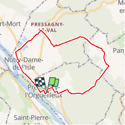
Tour Wandern von 14,2 km verfügbar auf Normandie, Eure, Pressagny-l'Orgueilleux. Diese Tour wird von douneto vorgeschlagen.
Beschreibung
Rando Novembre 2013
Attention période chasse dans Bois du château goujon le lundi, Jeudi et Dimanche !!!(une partie du chemin balisé est privé)
Ort
Land:
France
Region :
Normandie
Abteilung/Provinz :
Eure
Kommune :
Pressagny-l'Orgueilleux
Standort:
Unknown
Gehen Sie:(Dec)
Gehen Sie:(UTM)
386525 ; 5443275 (31U) N.
Kommentare
Touren in der Umgebung
![Tour Wandern Vernon - Les falaises de Seine de Vernon à Mantes la Jolie - Photo](https://media.geolcdn.com/t/375/260/5fb6d91d-220e-4b46-8986-f386f1d9411e.jpg&format=jpg&maxdim=2)
![Wandern Wandern](https://static1.geolcdn.com/sitytour/trail-icons/101.png)
Les falaises de Seine de Vernon à Mantes la Jolie
Wandern
Schwierig
Vernon,
Normandie,
Eure,
France
![](/images/other/stat-length.png)
37 km | 47 km-effort
7h 38min
![](https://static1.geolcdn.com/siteimages/upload/files/16400158638029165_repeat_loop_refresh_sync_direction_icon.png)
Nein
![Tour Wandern Mézières-en-Vexin - Mézières-en-Vexin - François 1er - Photo](https://media.geolcdn.com/t/375/260/ext.jpg?maxdim=2&url=https%3A%2F%2Fstatic1.geolcdn.com%2Fsiteimages%2Fupload%2Ffiles%2F1553511878bg_sport_marche.png)
![Wandern Wandern](https://static1.geolcdn.com/sitytour/trail-icons/101.png)
Mézières-en-Vexin - François 1er
Wandern
Einfach
(1)
Mézières-en-Vexin,
Normandie,
Eure,
France
![](/images/other/stat-length.png)
11 km | 13,1 km-effort
2h 50min
![](https://static1.geolcdn.com/siteimages/upload/files/16400158638029165_repeat_loop_refresh_sync_direction_icon.png)
Ja
![Tour Wandern La Chapelle-Longueville - Saint Just - Les coteaux de Seine - Photo](https://media.geolcdn.com/t/375/260/ext.jpg?maxdim=2&url=https%3A%2F%2Fstatic1.geolcdn.com%2Fsiteimages%2Fupload%2Ffiles%2F1553511878bg_sport_marche.png)
![Wandern Wandern](https://static1.geolcdn.com/sitytour/trail-icons/101.png)
Saint Just - Les coteaux de Seine
Wandern
Einfach
(4)
La Chapelle-Longueville,
Normandie,
Eure,
France
![](/images/other/stat-length.png)
10,5 km | 13,8 km-effort
2h 57min
![](https://static1.geolcdn.com/siteimages/upload/files/16400158638029165_repeat_loop_refresh_sync_direction_icon.png)
Ja
![Tour Wandern Saint-Pierre-de-Bailleul - A la rencontre des lavoirs - Photo](https://media.geolcdn.com/t/375/260/b40e3295-f250-42fc-a673-b0658115f2e1.jpg&format=jpg&maxdim=2)
![Wandern Wandern](https://static1.geolcdn.com/sitytour/trail-icons/101.png)
A la rencontre des lavoirs
Wandern
Medium
Saint-Pierre-de-Bailleul,
Normandie,
Eure,
France
![](/images/other/stat-length.png)
9,9 km | 12,6 km-effort
2h 50min
![](https://static1.geolcdn.com/siteimages/upload/files/16400158638029165_repeat_loop_refresh_sync_direction_icon.png)
Ja
![Tour Mountainbike Vernon - Les prés de Vernonnet - Vernon - Photo](https://media.geolcdn.com/t/375/260/ext.jpg?maxdim=2&url=https%3A%2F%2Fservices.sitytrail.com%2FGeolivesWS%2FDownloadMedia.ashx%3FTrailID%3D112611%26Media%3D11135_5.jpg)
![Mountainbike Mountainbike](https://static1.geolcdn.com/sitytour/trail-icons/202.png)
Les prés de Vernonnet - Vernon
Mountainbike
Einfach
Vernon,
Normandie,
Eure,
France
![](/images/other/stat-length.png)
3,3 km | 3,7 km-effort
19min
![](https://static1.geolcdn.com/siteimages/upload/files/16400158638029165_repeat_loop_refresh_sync_direction_icon.png)
Ja
![Tour Wandern Vernon - Les prés de Vernonnet - Vernon - Photo](https://media.geolcdn.com/t/375/260/ext.jpg?maxdim=2&url=https%3A%2F%2Fservices.sitytrail.com%2FGeolivesWS%2FDownloadMedia.ashx%3FTrailID%3D112610%26Media%3D11135_5.jpg)
![Wandern Wandern](https://static1.geolcdn.com/sitytour/trail-icons/101.png)
Les prés de Vernonnet - Vernon
Wandern
Einfach
Vernon,
Normandie,
Eure,
France
![](/images/other/stat-length.png)
3,3 km | 3,7 km-effort
49min
![](https://static1.geolcdn.com/siteimages/upload/files/16400158638029165_repeat_loop_refresh_sync_direction_icon.png)
Ja
![Tour Wandern Vernon - Entre musée et château - Vernon - Photo](https://media.geolcdn.com/t/375/260/ext.jpg?maxdim=2&url=https%3A%2F%2Fservices.sitytrail.com%2FGeolivesWS%2FDownloadMedia.ashx%3FTrailID%3D112597%26Media%3D11073_6.jpg)
![Wandern Wandern](https://static1.geolcdn.com/sitytour/trail-icons/101.png)
Entre musée et château - Vernon
Wandern
Einfach
Vernon,
Normandie,
Eure,
France
![](/images/other/stat-length.png)
7,7 km | 9,6 km-effort
2h 0min
![](https://static1.geolcdn.com/siteimages/upload/files/16400158638029165_repeat_loop_refresh_sync_direction_icon.png)
Ja
![Tour Wandern Vernon - Randonnée entre Seine et Forêt - Vernon - Photo](https://media.geolcdn.com/t/375/260/ext.jpg?maxdim=2&url=https%3A%2F%2Fservices.sitytrail.com%2FGeolivesWS%2FDownloadMedia.ashx%3FTrailID%3D112578%26Media%3D10992_3.jpg)
![Wandern Wandern](https://static1.geolcdn.com/sitytour/trail-icons/101.png)
Randonnée entre Seine et Forêt - Vernon
Wandern
Einfach
Vernon,
Normandie,
Eure,
France
![](/images/other/stat-length.png)
7,7 km | 9,5 km-effort
2h 0min
![](https://static1.geolcdn.com/siteimages/upload/files/16400158638029165_repeat_loop_refresh_sync_direction_icon.png)
Ja
![Tour Mountainbike Vernon - Circuit de la Colline aux oiseaux - Vernon - Photo](https://media.geolcdn.com/t/375/260/ext.jpg?maxdim=2&url=https%3A%2F%2Fservices.sitytrail.com%2FGeolivesWS%2FDownloadMedia.ashx%3FTrailID%3D112577%26Media%3D10990_2.jpg)
![Mountainbike Mountainbike](https://static1.geolcdn.com/sitytour/trail-icons/202.png)
Circuit de la Colline aux oiseaux - Vernon
Mountainbike
Einfach
Vernon,
Normandie,
Eure,
France
![](/images/other/stat-length.png)
5,9 km | 7,3 km-effort
30min
![](https://static1.geolcdn.com/siteimages/upload/files/16400158638029165_repeat_loop_refresh_sync_direction_icon.png)
Ja