![](/images/other/stat-length.png)
![Tour Wandern Marcy - Marcy-en-Beaujolais 17,5 km - Photo](https://media.geolcdn.com/t/1900/400/ext.pjpeg?maxdim=2&url=https%3A%2F%2Fstatic1.geolcdn.com%2Fsiteimages%2Fupload%2Ffiles%2F1553511878bg_sport_marche.png)
Marcy-en-Beaujolais 17,5 km
Thomasdanielle
Benutzer
![Länge](/images/other/stat-length.png)
Länge
17,5 km
![Maximale Höhe](https://static1.geolcdn.com/siteimages/upload/files/1508320355ic_sort_altitude_max_24dp.png)
Maximale Höhe
435 m
![Positive Höhendifferenz](https://static1.geolcdn.com/siteimages/upload/files/1508320355ic_sort_den_pos_24dp.png)
Positive Höhendifferenz
444 m
![Km-Effort](/images/other/stat-length.png)
Km-Effort
23 km
![Min. Höhe](https://static1.geolcdn.com/siteimages/upload/files/1508320355ic_sort_altitude_min_24dp.png)
Min. Höhe
223 m
![Negative Höhendifferenz](https://static1.geolcdn.com/siteimages/upload/files/1508320355ic_sort_den_neg_24dp.png)
Negative Höhendifferenz
447 m
![Boucle](https://static1.geolcdn.com/siteimages/upload/files/16400158638029165_repeat_loop_refresh_sync_direction_icon.png)
Boucle
Ja
Erstellungsdatum :
2018-04-17 19:27:42.507
Letzte Änderung :
2018-04-17 19:27:42.507
![Wandern](https://static1.geolcdn.com/sitytour/trail-icons/101.png)
4h57
Schwierigkeit : Einfach
![Scannen Sie diesen QR-Code, um die Tour in der SityTrail-Anwendung zu öffnen](https://capi.geolives.com/qq0zvz2zws4bq2lad0pu/sitytour/trails/908859/qr.png?size=200)
Kostenlosegpshiking-Anwendung
Über SityTrail
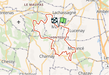
Tour Wandern von 17,5 km verfügbar auf Auvergne-Rhone-Alpen, Rhône, Marcy. Diese Tour wird von Thomasdanielle vorgeschlagen.
Beschreibung
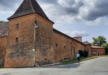
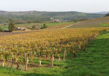
Belle randonnée le 19/02/2018, ensoleillée. Départ/Arrivée parking en rentrant au centre du village
17,5 km - D. 432 m
Ort
Land:
France
Region :
Auvergne-Rhone-Alpen
Abteilung/Provinz :
Rhône
Kommune :
Marcy
Standort:
Unknown
Gehen Sie:(Dec)
Gehen Sie:(UTM)
630350 ; 5085939 (31T) N.
Kommentare
Touren in der Umgebung
![Tour Zu Fuß Saint-Jean-des-Vignes - De Bagnols à Lozanne - Photo](https://media.geolcdn.com/t/375/260/0483cf43-fc67-45ae-bc2f-363ddcb48e98.jpeg&format=jpg&maxdim=2)
![Zu Fuß Zu Fuß](https://static1.geolcdn.com/sitytour/trail-icons/100.png)
De Bagnols à Lozanne
Zu Fuß
Einfach
Saint-Jean-des-Vignes,
Auvergne-Rhone-Alpen,
Rhône,
France
![](/images/other/stat-length.png)
4 km | 5 km-effort
1h 7min
![](https://static1.geolcdn.com/siteimages/upload/files/16400158638029165_repeat_loop_refresh_sync_direction_icon.png)
Nein
![Tour Nordic Walking Bagnols - bagnol - Photo](https://media.geolcdn.com/t/375/260/ext.jpg?maxdim=2&url=https%3A%2F%2Fstatic1.geolcdn.com%2Fsiteimages%2Fupload%2Ffiles%2F1545311037marcheuse_200dpi.jpg)
![Nordic Walking Nordic Walking](https://static1.geolcdn.com/sitytour/trail-icons/102.png)
bagnol
Nordic Walking
Sehr leicht
(1)
Bagnols,
Auvergne-Rhone-Alpen,
Rhône,
France
![](/images/other/stat-length.png)
6,8 km | 8,4 km-effort
1h 40min
![](https://static1.geolcdn.com/siteimages/upload/files/16400158638029165_repeat_loop_refresh_sync_direction_icon.png)
Ja
![Tour Wandern Saint-Jean-des-Vignes - A_ST JEAN DES VIGNES 69380 Pierre Folle - Fontainebleau - Photo](https://media.geolcdn.com/t/375/260/ext.jpg?maxdim=2&url=https%3A%2F%2Fstatic1.geolcdn.com%2Fsiteimages%2Fupload%2Ffiles%2F1553511878bg_sport_marche.png)
![Wandern Wandern](https://static1.geolcdn.com/sitytour/trail-icons/101.png)
A_ST JEAN DES VIGNES 69380 Pierre Folle - Fontainebleau
Wandern
Einfach
(1)
Saint-Jean-des-Vignes,
Auvergne-Rhone-Alpen,
Rhône,
France
![](/images/other/stat-length.png)
8 km | 11 km-effort
3h 0min
![](https://static1.geolcdn.com/siteimages/upload/files/16400158638029165_repeat_loop_refresh_sync_direction_icon.png)
Ja
![Tour Wandern Morancé - morance - Photo](https://media.geolcdn.com/t/375/260/ext.jpg?maxdim=2&url=https%3A%2F%2Fstatic1.geolcdn.com%2Fsiteimages%2Fupload%2Ffiles%2F1553511878bg_sport_marche.png)
![Wandern Wandern](https://static1.geolcdn.com/sitytour/trail-icons/101.png)
morance
Wandern
Sehr leicht
(1)
Morancé,
Auvergne-Rhone-Alpen,
Rhône,
France
![](/images/other/stat-length.png)
7,9 km | 9,7 km-effort
1h 46min
![](https://static1.geolcdn.com/siteimages/upload/files/16400158638029165_repeat_loop_refresh_sync_direction_icon.png)
Ja
![Tour Wandern Chessy - Chessy 11 km - Photo](https://media.geolcdn.com/t/375/260/ext.jpg?maxdim=2&url=https%3A%2F%2Fstatic1.geolcdn.com%2Fsiteimages%2Fupload%2Ffiles%2F1553511878bg_sport_marche.png)
![Wandern Wandern](https://static1.geolcdn.com/sitytour/trail-icons/101.png)
Chessy 11 km
Wandern
Schwierig
(1)
Chessy,
Auvergne-Rhone-Alpen,
Rhône,
France
![](/images/other/stat-length.png)
11,5 km | 14,9 km-effort
3h 23min
![](https://static1.geolcdn.com/siteimages/upload/files/16400158638029165_repeat_loop_refresh_sync_direction_icon.png)
Ja
![Tour Reiten Les Chères - 5 nov formation - Photo](https://media.geolcdn.com/t/375/260/ext.jpg?maxdim=2&url=https%3A%2F%2Fstatic1.geolcdn.com%2Fsiteimages%2Fupload%2Ffiles%2F1524743154cheval.jpg)
![Reiten Reiten](https://static1.geolcdn.com/sitytour/trail-icons/301.png)
5 nov formation
Reiten
Einfach
(2)
Les Chères,
Auvergne-Rhone-Alpen,
Rhône,
France
![](/images/other/stat-length.png)
13,6 km | 15 km-effort
1h 58min
![](https://static1.geolcdn.com/siteimages/upload/files/16400158638029165_repeat_loop_refresh_sync_direction_icon.png)
Ja
![Tour Wandern Chessy - Chessy à Bagnols - Photo](https://media.geolcdn.com/t/375/260/1a8d6b74-bd94-4883-b228-58b5e533ca39.jpg&format=jpg&maxdim=2)
![Wandern Wandern](https://static1.geolcdn.com/sitytour/trail-icons/101.png)
Chessy à Bagnols
Wandern
Schwierig
(1)
Chessy,
Auvergne-Rhone-Alpen,
Rhône,
France
![](/images/other/stat-length.png)
12,5 km | 15,8 km-effort
3h 35min
![](https://static1.geolcdn.com/siteimages/upload/files/16400158638029165_repeat_loop_refresh_sync_direction_icon.png)
Ja
![Tour Wandern Charnay - Charnay/Châtillon/Chessy (12 km - D. 330 m) - Photo](https://media.geolcdn.com/t/375/260/1a2d3b7e-3e2e-464b-b810-b35fd7c37452.jpeg&format=jpg&maxdim=2)
![Wandern Wandern](https://static1.geolcdn.com/sitytour/trail-icons/101.png)
Charnay/Châtillon/Chessy (12 km - D. 330 m)
Wandern
Einfach
Charnay,
Auvergne-Rhone-Alpen,
Rhône,
France
![](/images/other/stat-length.png)
12,5 km | 16,9 km-effort
3h 7min
![](https://static1.geolcdn.com/siteimages/upload/files/16400158638029165_repeat_loop_refresh_sync_direction_icon.png)
Ja
![Tour Wandern Chessy - Chessy - Carrières de Gray - Photo](https://media.geolcdn.com/t/375/260/8d7c8e26-fc30-4464-a10b-7b34cdc4f32c.jpg&format=jpg&maxdim=2)
![Wandern Wandern](https://static1.geolcdn.com/sitytour/trail-icons/101.png)
Chessy - Carrières de Gray
Wandern
Sehr leicht
Chessy,
Auvergne-Rhone-Alpen,
Rhône,
France
![](/images/other/stat-length.png)
9,7 km | 13 km-effort
2h 33min
![](https://static1.geolcdn.com/siteimages/upload/files/16400158638029165_repeat_loop_refresh_sync_direction_icon.png)
Ja