![](/images/other/stat-length.png)
![Tour Nordic Walking Sint-Genesius-Rode - Wanowa -Marche Nordique courte à la Grande Espinette - Photo](https://media.geolcdn.com/t/1900/400/ext.pjpeg?maxdim=2&url=https%3A%2F%2Fstatic1.geolcdn.com%2Fsiteimages%2Fupload%2Ffiles%2F1545311037marcheuse_200dpi.jpg)
Wanowa -Marche Nordique courte à la Grande Espinette
anneliseldw
Benutzer
![Länge](/images/other/stat-length.png)
Länge
4,3 km
![Maximale Höhe](https://static1.geolcdn.com/siteimages/upload/files/1508320355ic_sort_altitude_max_24dp.png)
Maximale Höhe
152 m
![Positive Höhendifferenz](https://static1.geolcdn.com/siteimages/upload/files/1508320355ic_sort_den_pos_24dp.png)
Positive Höhendifferenz
49 m
![Km-Effort](/images/other/stat-length.png)
Km-Effort
4,9 km
![Min. Höhe](https://static1.geolcdn.com/siteimages/upload/files/1508320355ic_sort_altitude_min_24dp.png)
Min. Höhe
120 m
![Negative Höhendifferenz](https://static1.geolcdn.com/siteimages/upload/files/1508320355ic_sort_den_neg_24dp.png)
Negative Höhendifferenz
48 m
![Boucle](https://static1.geolcdn.com/siteimages/upload/files/16400158638029165_repeat_loop_refresh_sync_direction_icon.png)
Boucle
Ja
Erstellungsdatum :
2014-12-10 00:00:00.0
Letzte Änderung :
2014-12-10 00:00:00.0
![Nordic Walking](https://static1.geolcdn.com/sitytour/trail-icons/102.png)
--
Schwierigkeit : Einfach
![Scannen Sie diesen QR-Code, um die Tour in der SityTrail-Anwendung zu öffnen](https://capi.geolives.com/qq0zvz2zws4bq2lad0pu/sitytour/trails/90508/qr.png?size=200)
Kostenlosegpshiking-Anwendung
Über SityTrail
Tour Nordic Walking von 4,3 km verfügbar auf Flandern, Flämisch-Brabant, Sint-Genesius-Rode. Diese Tour wird von anneliseldw vorgeschlagen.
Beschreibung
Promenade en marche nordique 5/11/2011
Niveau débutant - courte distance - OK pour améliorer la technique MN
Ort
Land:
Belgium
Region :
Flandern
Abteilung/Provinz :
Flämisch-Brabant
Kommune :
Sint-Genesius-Rode
Standort:
Sint-Genesius-Rode
Gehen Sie:(Dec)
Gehen Sie:(UTM)
599566 ; 5621835 (31U) N.
Kommentare
Touren in der Umgebung
![Tour Wandern Hoeilaart - GG-Bw-04_Hoeilaart - Genval - Photo](https://media.geolcdn.com/t/375/260/364592d0-bbf8-45ce-9ea9-708b8ca7581f.jpg&format=jpg&maxdim=2)
![Wandern Wandern](https://static1.geolcdn.com/sitytour/trail-icons/101.png)
GG-Bw-04_Hoeilaart - Genval
Wandern
Sehr schwierig
(6)
Hoeilaart,
Flandern,
Flämisch-Brabant,
Belgium
![](/images/other/stat-length.png)
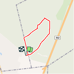
23 km | 28 km-effort
5h 54min
![](https://static1.geolcdn.com/siteimages/upload/files/16400158638029165_repeat_loop_refresh_sync_direction_icon.png)
Nein
![Tour Wandern La Hulpe - RB-Bw-12 - Raccourci - Forêt et campagnes au sud de Bruxelles - Photo](https://media.geolcdn.com/t/375/260/ext.jpg?maxdim=2&url=https%3A%2F%2Fservices.sitytrail.com%2FGeolivesWS%2FDownloadMedia.ashx%3FTrailID%3D220408%26Media%3D24b0bc9e-ebac-4d93-8d00-eff7571ad0a0.jpg)
![Wandern Wandern](https://static1.geolcdn.com/sitytour/trail-icons/101.png)
RB-Bw-12 - Raccourci - Forêt et campagnes au sud de Bruxelles
Wandern
Schwierig
(16)
La Hulpe,
Wallonien,
Wallonisch-Brabant,
Belgium
![](/images/other/stat-length.png)
14,3 km | 17,7 km-effort
4h 1min
![](https://static1.geolcdn.com/siteimages/upload/files/16400158638029165_repeat_loop_refresh_sync_direction_icon.png)
Ja
![Tour Mountainbike Sint-Genesius-Rode - VTT des etangs - Photo](https://media.geolcdn.com/t/375/260/ext.jpg?maxdim=2&url=https%3A%2F%2Fservices.sitytrail.com%2FGeolivesWS%2FDownloadMedia.ashx%3FTrailID%3D672124%26Media%3Df9c91142-2f99-4e68-a9bd-48ecc49645c7.JPG)
![Mountainbike Mountainbike](https://static1.geolcdn.com/sitytour/trail-icons/202.png)
VTT des etangs
Mountainbike
Medium
(1)
Sint-Genesius-Rode,
Flandern,
Flämisch-Brabant,
Belgium
![](/images/other/stat-length.png)
31 km | 37 km-effort
2h 24min
![](https://static1.geolcdn.com/siteimages/upload/files/16400158638029165_repeat_loop_refresh_sync_direction_icon.png)
Nein
![Tour Wandern La Hulpe - La Hulpe - Circuit Natura 2000, des sites qui valent le détour - Bw02 - Photo](https://media.geolcdn.com/t/375/260/7fa79586-43de-4fc0-89c7-4bc45138438a.jpg&format=jpg&maxdim=2)
![Wandern Wandern](https://static1.geolcdn.com/sitytour/trail-icons/101.png)
La Hulpe - Circuit Natura 2000, des sites qui valent le détour - Bw02
Wandern
Medium
(5)
La Hulpe,
Wallonien,
Wallonisch-Brabant,
Belgium
![](/images/other/stat-length.png)
4,7 km | 5,9 km-effort
1h 16min
![](https://static1.geolcdn.com/siteimages/upload/files/16400158638029165_repeat_loop_refresh_sync_direction_icon.png)
Nein
![Tour Mountainbike Sint-Genesius-Rode - vtt de la forêt de Soigne - Photo](https://media.geolcdn.com/t/375/260/ext.jpg?maxdim=2&url=https%3A%2F%2Fservices.sitytrail.com%2FGeolivesWS%2FDownloadMedia.ashx%3FTrailID%3D394333%26Media%3Daba8d68d-2f84-442f-b081-8683a39ccf4b.JPG)
![Mountainbike Mountainbike](https://static1.geolcdn.com/sitytour/trail-icons/202.png)
vtt de la forêt de Soigne
Mountainbike
Einfach
(1)
Sint-Genesius-Rode,
Flandern,
Flämisch-Brabant,
Belgium
![](/images/other/stat-length.png)
31 km | 38 km-effort
2h 27min
![](https://static1.geolcdn.com/siteimages/upload/files/16400158638029165_repeat_loop_refresh_sync_direction_icon.png)
Ja
![Tour Wandern Sint-Genesius-Rode - De Rhode Saint-Genèse à Groenendaal parl la forêt de Soignes - Photo](https://media.geolcdn.com/t/375/260/ext.jpg?maxdim=2&url=https%3A%2F%2Fservices.sitytrail.com%2FGeolivesWS%2FDownloadMedia.ashx%3FTrailID%3D361516%26Media%3Dafc15552-96c3-47a7-a25a-a7fd8498bfed.JPG)
![Wandern Wandern](https://static1.geolcdn.com/sitytour/trail-icons/101.png)
De Rhode Saint-Genèse à Groenendaal parl la forêt de Soignes
Wandern
Einfach
(4)
Sint-Genesius-Rode,
Flandern,
Flämisch-Brabant,
Belgium
![](/images/other/stat-length.png)
10,3 km | 11,9 km-effort
2h 36min
![](https://static1.geolcdn.com/siteimages/upload/files/16400158638029165_repeat_loop_refresh_sync_direction_icon.png)
Ja
![Tour Fahrrad Waterloo - Du Domaine Solvay (Château de La Hulpe + Fondation Folon) à la Butte du Lion - Photo](https://media.geolcdn.com/t/375/260/6e2b14e5-7f01-4b82-86ec-767250ffcdcd.jpg&format=jpg&maxdim=2)
![Fahrrad Fahrrad](https://static1.geolcdn.com/sitytour/trail-icons/200.png)
Du Domaine Solvay (Château de La Hulpe + Fondation Folon) à la Butte du Lion
Fahrrad
Sehr leicht
(2)
Waterloo,
Wallonien,
Wallonisch-Brabant,
Belgium
![](/images/other/stat-length.png)
28 km | 32 km-effort
Unbekannt
![](https://static1.geolcdn.com/siteimages/upload/files/16400158638029165_repeat_loop_refresh_sync_direction_icon.png)
Nein
![Mountainbike Mountainbike](https://static1.geolcdn.com/sitytour/trail-icons/202.png)
VTT 42 km la hulpe
Mountainbike
Medium
(1)
La Hulpe,
Wallonien,
Wallonisch-Brabant,
Belgium
![](/images/other/stat-length.png)
40 km | 48 km-effort
2h 20min
![](https://static1.geolcdn.com/siteimages/upload/files/16400158638029165_repeat_loop_refresh_sync_direction_icon.png)
Ja
![Tour Wandern La Hulpe - château de la hulpe - Photo](https://media.geolcdn.com/t/375/260/2b88449b-b2f0-4b13-8225-abe55fc9e2b1.jpg&format=jpg&maxdim=2)
![Wandern Wandern](https://static1.geolcdn.com/sitytour/trail-icons/101.png)
château de la hulpe
Wandern
Sehr leicht
(2)
La Hulpe,
Wallonien,
Wallonisch-Brabant,
Belgium
![](/images/other/stat-length.png)
10,8 km | 13,2 km-effort
3h 27min
![](https://static1.geolcdn.com/siteimages/upload/files/16400158638029165_repeat_loop_refresh_sync_direction_icon.png)
Ja