![](/images/other/stat-length.png)
![Tour Wandern Bouère - De Bouère à St-Brice - Photo](https://media.geolcdn.com/t/1900/400/ext.pjpeg?maxdim=2&url=https%3A%2F%2Fstatic1.geolcdn.com%2Fsiteimages%2Fupload%2Ffiles%2F1553511878bg_sport_marche.png)
De Bouère à St-Brice
neoroll44
Benutzer
![Länge](/images/other/stat-length.png)
Länge
13 km
![Maximale Höhe](https://static1.geolcdn.com/siteimages/upload/files/1508320355ic_sort_altitude_max_24dp.png)
Maximale Höhe
83 m
![Positive Höhendifferenz](https://static1.geolcdn.com/siteimages/upload/files/1508320355ic_sort_den_pos_24dp.png)
Positive Höhendifferenz
142 m
![Km-Effort](/images/other/stat-length.png)
Km-Effort
14,9 km
![Min. Höhe](https://static1.geolcdn.com/siteimages/upload/files/1508320355ic_sort_altitude_min_24dp.png)
Min. Höhe
46 m
![Negative Höhendifferenz](https://static1.geolcdn.com/siteimages/upload/files/1508320355ic_sort_den_neg_24dp.png)
Negative Höhendifferenz
143 m
![Boucle](https://static1.geolcdn.com/siteimages/upload/files/16400158638029165_repeat_loop_refresh_sync_direction_icon.png)
Boucle
Ja
Erstellungsdatum :
2018-04-17 16:59:16.576
Letzte Änderung :
2018-04-17 16:59:16.576
![Wandern](https://static1.geolcdn.com/sitytour/trail-icons/101.png)
3h15
Schwierigkeit : Medium
![Scannen Sie diesen QR-Code, um die Tour in der SityTrail-Anwendung zu öffnen](https://capi.geolives.com/qq0zvz2zws4bq2lad0pu/sitytour/trails/893860/qr.png?size=200)
Kostenlosegpshiking-Anwendung
Über SityTrail
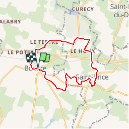
Tour Wandern von 13 km verfügbar auf Pays de la Loire, Mayenne, Bouère. Diese Tour wird von neoroll44 vorgeschlagen.
Beschreibung
Non loin de la forêt de Bellebranche.
De l'église, prendre le CD 14 vers Grez en Bouère, puis à droite vers la croix verte.
Puis le Moulin Neuf, Manchetière, près de Bellebranche et retour par St-Brice et le plan d'eau.
Ort
Land:
France
Region :
Pays de la Loire
Abteilung/Provinz :
Mayenne
Kommune :
Bouère
Standort:
Unknown
Gehen Sie:(Dec)
Gehen Sie:(UTM)
688652 ; 5304229 (30T) N.
Kommentare
Touren in der Umgebung
![Tour Wandern Bouère - Bouère. Circuit N4 - Photo](https://media.geolcdn.com/t/375/260/ext.jpg?maxdim=2&url=https%3A%2F%2Fstatic1.geolcdn.com%2Fsiteimages%2Fupload%2Ffiles%2F1553511878bg_sport_marche.png)
![Wandern Wandern](https://static1.geolcdn.com/sitytour/trail-icons/101.png)
Bouère. Circuit N4
Wandern
Einfach
(1)
Bouère,
Pays de la Loire,
Mayenne,
France
![](/images/other/stat-length.png)
4,5 km | 5,4 km-effort
1h 38min
![](https://static1.geolcdn.com/siteimages/upload/files/16400158638029165_repeat_loop_refresh_sync_direction_icon.png)
Ja
![Tour Wandern Grez-en-Bouère - Grez en Bouère - Photo](https://media.geolcdn.com/t/375/260/ext.jpg?maxdim=2&url=https%3A%2F%2Fstatic1.geolcdn.com%2Fsiteimages%2Fupload%2Ffiles%2F1553511878bg_sport_marche.png)
![Wandern Wandern](https://static1.geolcdn.com/sitytour/trail-icons/101.png)
Grez en Bouère
Wandern
Medium
Grez-en-Bouère,
Pays de la Loire,
Mayenne,
France
![](/images/other/stat-length.png)
12,8 km | 14,8 km-effort
3h 20min
![](https://static1.geolcdn.com/siteimages/upload/files/16400158638029165_repeat_loop_refresh_sync_direction_icon.png)
Ja
![Tour Wandern Saint-Brice - 2024 06 02 bellebranche - Photo](https://media.geolcdn.com/t/375/260/ext.jpg?maxdim=2&url=https%3A%2F%2Fstatic1.geolcdn.com%2Fsiteimages%2Fupload%2Ffiles%2F1553511878bg_sport_marche.png)
![Wandern Wandern](https://static1.geolcdn.com/sitytour/trail-icons/101.png)
2024 06 02 bellebranche
Wandern
Einfach
Saint-Brice,
Pays de la Loire,
Mayenne,
France
![](/images/other/stat-length.png)
9 km | 10,4 km-effort
1h 59min
![](https://static1.geolcdn.com/siteimages/upload/files/16400158638029165_repeat_loop_refresh_sync_direction_icon.png)
Ja
![Tour Geocaching Saint-Loup-du-Dorat - Labyrinthe Alice Juillet 2022 - Photo](https://media.geolcdn.com/t/375/260/ext.jpg?maxdim=2&url=https%3A%2F%2Fstatic1.geolcdn.com%2Fsiteimages%2Fupload%2Ffiles%2F1545311037marcheuse_200dpi.jpg)
![Geocaching Geocaching](https://static1.geolcdn.com/sitytour/trail-icons/908.png)
Labyrinthe Alice Juillet 2022
Geocaching
Medium
Saint-Loup-du-Dorat,
Pays de la Loire,
Mayenne,
France
![](/images/other/stat-length.png)
11,8 km | 13,1 km-effort
2h 50min
![](https://static1.geolcdn.com/siteimages/upload/files/16400158638029165_repeat_loop_refresh_sync_direction_icon.png)
Nein
![Tour Wandern Bouère - de Bouère à Grez - Photo](https://media.geolcdn.com/t/375/260/ext.jpg?maxdim=2&url=https%3A%2F%2Fstatic1.geolcdn.com%2Fsiteimages%2Fupload%2Ffiles%2F1553511878bg_sport_marche.png)
![Wandern Wandern](https://static1.geolcdn.com/sitytour/trail-icons/101.png)
de Bouère à Grez
Wandern
Sehr leicht
Bouère,
Pays de la Loire,
Mayenne,
France
![](/images/other/stat-length.png)
14,4 km | 16,6 km-effort
3h 55min
![](https://static1.geolcdn.com/siteimages/upload/files/16400158638029165_repeat_loop_refresh_sync_direction_icon.png)
Ja
![Tour Wandern Bouère - Bouère. autour du village - Photo](https://media.geolcdn.com/t/375/260/ext.jpg?maxdim=2&url=https%3A%2F%2Fstatic1.geolcdn.com%2Fsiteimages%2Fupload%2Ffiles%2F1553511878bg_sport_marche.png)
![Wandern Wandern](https://static1.geolcdn.com/sitytour/trail-icons/101.png)
Bouère. autour du village
Wandern
Medium
Bouère,
Pays de la Loire,
Mayenne,
France
![](/images/other/stat-length.png)
11,4 km | 13,1 km-effort
3h 5min
![](https://static1.geolcdn.com/siteimages/upload/files/16400158638029165_repeat_loop_refresh_sync_direction_icon.png)
Ja
![Tour Wandern Saint-Brice - Saint-Brice Marche à pied - Photo](https://media.geolcdn.com/t/375/260/ext.jpg?maxdim=2&url=https%3A%2F%2Fstatic1.geolcdn.com%2Fsiteimages%2Fupload%2Ffiles%2F1553511878bg_sport_marche.png)
![Wandern Wandern](https://static1.geolcdn.com/sitytour/trail-icons/101.png)
Saint-Brice Marche à pied
Wandern
Medium
Saint-Brice,
Pays de la Loire,
Mayenne,
France
![](/images/other/stat-length.png)
9,2 km | 10,6 km-effort
2h 19min
![](https://static1.geolcdn.com/siteimages/upload/files/16400158638029165_repeat_loop_refresh_sync_direction_icon.png)
Ja