![](/images/other/stat-length.png)
![Tour Mountainbike Ouffet - OUFFET - Balade de Raou - Photo](https://media.geolcdn.com/t/1900/400/ext.pjpeg?maxdim=2&url=https%3A%2F%2Fstatic1.geolcdn.com%2Fsiteimages%2Fupload%2Ffiles%2F1524743154velo.jpg)
OUFFET - Balade de Raou
gk@icedd.be
Benutzer
![Länge](/images/other/stat-length.png)
Länge
5,9 km
![Maximale Höhe](https://static1.geolcdn.com/siteimages/upload/files/1508320355ic_sort_altitude_max_24dp.png)
Maximale Höhe
286 m
![Positive Höhendifferenz](https://static1.geolcdn.com/siteimages/upload/files/1508320355ic_sort_den_pos_24dp.png)
Positive Höhendifferenz
80 m
![Km-Effort](/images/other/stat-length.png)
Km-Effort
7 km
![Min. Höhe](https://static1.geolcdn.com/siteimages/upload/files/1508320355ic_sort_altitude_min_24dp.png)
Min. Höhe
226 m
![Negative Höhendifferenz](https://static1.geolcdn.com/siteimages/upload/files/1508320355ic_sort_den_neg_24dp.png)
Negative Höhendifferenz
80 m
![Boucle](https://static1.geolcdn.com/siteimages/upload/files/16400158638029165_repeat_loop_refresh_sync_direction_icon.png)
Boucle
Ja
![Kennzeichnung](https://services.sitytrail.com/GeolivesWS/DownloadMedia.ashx?TrailID=891188&Media=balise.png)
Kennzeichnung
Erstellungsdatum :
2018-04-17 16:38:33.156
Letzte Änderung :
2018-04-17 16:38:33.156
![Mountainbike](https://static1.geolcdn.com/sitytour/trail-icons/202.png)
30m
Schwierigkeit : Medium
![Scannen Sie diesen QR-Code, um die Tour in der SityTrail-Anwendung zu öffnen](https://capi.geolives.com/qq0zvz2zws4bq2lad0pu/sitytour/trails/891188/qr.png?size=200)
Kostenlosegpshiking-Anwendung
Über SityTrail
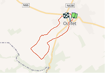
Tour Mountainbike von 5,9 km verfügbar auf Wallonien, Lüttich, Ouffet. Diese Tour wird von gk@icedd.be vorgeschlagen.
Beschreibung
Au départ de la Grand'Place d'Ouffet, cette petite promenade amène les randonneurs à déambuler dans les petites rues d'Ouffet chargées en histoire et patrimoine mais aussi à traverser une vaste plaine agricole.
Ort
Land:
Belgium
Region :
Wallonien
Abteilung/Provinz :
Lüttich
Kommune :
Ouffet
Standort:
Ouffet
Gehen Sie:(Dec)
Gehen Sie:(UTM)
675088 ; 5590257 (31U) N.
Kommentare
Touren in der Umgebung
![Tour Wandern Anthisnes - Anthines - AS03 - Boucle de Tolumont - Losange Bleu - Photo](https://media.geolcdn.com/t/375/260/a3413dfd-3361-4d9b-b91d-7efec18943a3.jpg&format=jpg&maxdim=2)
![Wandern Wandern](https://static1.geolcdn.com/sitytour/trail-icons/101.png)
Anthines - AS03 - Boucle de Tolumont - Losange Bleu
Wandern
Medium
(2)
Anthisnes,
Wallonien,
Lüttich,
Belgium
![](/images/other/stat-length.png)
13,9 km | 18,2 km-effort
2h 56min
![](https://static1.geolcdn.com/siteimages/upload/files/16400158638029165_repeat_loop_refresh_sync_direction_icon.png)
Ja
![Tour Wandern Hamoir - HAMOIR (Vallée du Neblon) - Photo](https://media.geolcdn.com/t/375/260/bd133f9f-5595-47e8-88c0-4d09e83d3ba8.jpg&format=jpg&maxdim=2)
![Wandern Wandern](https://static1.geolcdn.com/sitytour/trail-icons/101.png)
HAMOIR (Vallée du Neblon)
Wandern
Medium
(1)
Hamoir,
Wallonien,
Lüttich,
Belgium
![](/images/other/stat-length.png)
8,6 km | 11,4 km-effort
2h 28min
![](https://static1.geolcdn.com/siteimages/upload/files/16400158638029165_repeat_loop_refresh_sync_direction_icon.png)
Ja
![Tour Zu Fuß Anthisnes - AS03 Boucle de Tolumont - Photo](https://media.geolcdn.com/t/375/260/bb3be3cf-eddc-4622-8273-ff9944f2671c.jpg&format=jpg&maxdim=2)
![Zu Fuß Zu Fuß](https://static1.geolcdn.com/sitytour/trail-icons/100.png)
AS03 Boucle de Tolumont
Zu Fuß
Medium
(1)
Anthisnes,
Wallonien,
Lüttich,
Belgium
![](/images/other/stat-length.png)
13,4 km | 17,6 km-effort
3h 20min
![](https://static1.geolcdn.com/siteimages/upload/files/16400158638029165_repeat_loop_refresh_sync_direction_icon.png)
Ja
![Tour Wandern Ferrières - GG-Lu-15_Sy - Barvaux - Photo](https://media.geolcdn.com/t/375/260/4cf6fb9a-77d5-4c51-bb72-4b6ca6a27202.jpg&format=jpg&maxdim=2)
![Wandern Wandern](https://static1.geolcdn.com/sitytour/trail-icons/101.png)
GG-Lu-15_Sy - Barvaux
Wandern
Sehr schwierig
(1)
Ferrières,
Wallonien,
Lüttich,
Belgium
![](/images/other/stat-length.png)
18,9 km | 26 km-effort
5h 58min
![](https://static1.geolcdn.com/siteimages/upload/files/16400158638029165_repeat_loop_refresh_sync_direction_icon.png)
Nein
![Tour Wandern Hamoir - Hamoir - Sy - Les Crêtes - Photo](https://media.geolcdn.com/t/375/260/2cd3e10e-e069-4884-9433-cbc8b49962aa.jpg&format=jpg&maxdim=2)
![Wandern Wandern](https://static1.geolcdn.com/sitytour/trail-icons/101.png)
Hamoir - Sy - Les Crêtes
Wandern
Medium
(1)
Hamoir,
Wallonien,
Lüttich,
Belgium
![](/images/other/stat-length.png)
13,1 km | 17,2 km-effort
3h 17min
![](https://static1.geolcdn.com/siteimages/upload/files/16400158638029165_repeat_loop_refresh_sync_direction_icon.png)
Ja
![Wandern Wandern](https://static1.geolcdn.com/sitytour/trail-icons/101.png)
![Tour Wandern Ouffet - ouffet fermes ac + - Photo](https://media.geolcdn.com/t/375/260/fd6ab0a5-da2e-4ec4-9fa1-96c42c21280a.jpg&format=jpg&maxdim=2)
![Wandern Wandern](https://static1.geolcdn.com/sitytour/trail-icons/101.png)
ouffet fermes ac +
Wandern
Medium
(2)
Ouffet,
Wallonien,
Lüttich,
Belgium
![](/images/other/stat-length.png)
8,6 km | 10,7 km-effort
2h 41min
![](https://static1.geolcdn.com/siteimages/upload/files/16400158638029165_repeat_loop_refresh_sync_direction_icon.png)
Ja
![Tour Wandern Hamoir - RB-Lg-19_Hamoir_via-racc-2 - Photo](https://media.geolcdn.com/t/375/260/ext.jpg?maxdim=2&url=https%3A%2F%2Fservices.sitytrail.com%2FGeolivesWS%2FDownloadMedia.ashx%3FTrailID%3D400607%26Media%3Dc0745639-8ded-479e-9345-a8c68cd61e6a.jpg)
![Wandern Wandern](https://static1.geolcdn.com/sitytour/trail-icons/101.png)
RB-Lg-19_Hamoir_via-racc-2
Wandern
Sehr schwierig
(5)
Hamoir,
Wallonien,
Lüttich,
Belgium
![](/images/other/stat-length.png)
16 km | 20 km-effort
4h 36min
![](https://static1.geolcdn.com/siteimages/upload/files/16400158638029165_repeat_loop_refresh_sync_direction_icon.png)
Ja
![Tour Wandern Hamoir - RB-Lg-19_Hamoir_via-racc-1 - Photo](https://media.geolcdn.com/t/375/260/ext.jpg?maxdim=2&url=https%3A%2F%2Fservices.sitytrail.com%2FGeolivesWS%2FDownloadMedia.ashx%3FTrailID%3D400604%26Media%3Dc0745639-8ded-479e-9345-a8c68cd61e6a.jpg)
![Wandern Wandern](https://static1.geolcdn.com/sitytour/trail-icons/101.png)
RB-Lg-19_Hamoir_via-racc-1
Wandern
Schwierig
(2)
Hamoir,
Wallonien,
Lüttich,
Belgium
![](/images/other/stat-length.png)
11,4 km | 15,1 km-effort
3h 26min
![](https://static1.geolcdn.com/siteimages/upload/files/16400158638029165_repeat_loop_refresh_sync_direction_icon.png)
Ja