![](/images/other/stat-length.png)
![Tour Wandern Le Dévoluy - R22 Le Col de Laup - Photo](https://media.geolcdn.com/t/1900/400/5be2046b-f6d9-4f56-9030-495acb887a49.jpg&format=pjpeg&maxdim=2)
R22 Le Col de Laup
Camping Les Rives du Lac
Les Hautes Alpes à découvrir ! GUIDE+
![Länge](/images/other/stat-length.png)
![Maximale Höhe](https://static1.geolcdn.com/siteimages/upload/files/1508320355ic_sort_altitude_max_24dp.png)
![Positive Höhendifferenz](https://static1.geolcdn.com/siteimages/upload/files/1508320355ic_sort_den_pos_24dp.png)
![Km-Effort](/images/other/stat-length.png)
![Min. Höhe](https://static1.geolcdn.com/siteimages/upload/files/1508320355ic_sort_altitude_min_24dp.png)
![Negative Höhendifferenz](https://static1.geolcdn.com/siteimages/upload/files/1508320355ic_sort_den_neg_24dp.png)
![Boucle](https://static1.geolcdn.com/siteimages/upload/files/16400158638029165_repeat_loop_refresh_sync_direction_icon.png)
![Wandern](https://static1.geolcdn.com/sitytour/trail-icons/101.png)
2h56
Schwierigkeit : Sehr leicht
![Scannen Sie diesen QR-Code, um die Tour in der SityTrail-Anwendung zu öffnen](https://capi.geolives.com/qq0zvz2zws4bq2lad0pu/sitytour/trails/890879/qr.png?size=200)
Kostenlosegpshiking-Anwendung
Über SityTrail
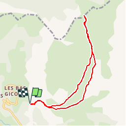
Tour Wandern von 8 km verfügbar auf Provence-Alpes-Côte d'Azur, Hochalpen, Le Dévoluy. Diese Tour wird von Camping Les Rives du Lac vorgeschlagen.
Beschreibung
Randonnée facile, très sauvage (flore incomparable), qui offre un panorama magnifique sur le massif du Dévoluy. La vue depuis le col est également remarquable. Possibilité de poursuivre cette randonnée jusqu’au point 1887 (soit 200m de dénivelé en plus, en partant à gauche (vers l’ouest) au niveau du col), pour une vue encore plus dégagée.
Profitez en pour vous arrêter à Mère Eglise, célèbre chapelle du XIème siècle.
Ort
Kommentare
Touren in der Umgebung
![Tour Wandern Le Dévoluy - R29 La crete des Beaumes - Photo](https://media.geolcdn.com/t/375/260/ext.jpg?maxdim=2&url=https%3A%2F%2Fservices.sitytrail.com%2FGeolivesWS%2FDownloadMedia.ashx%3FTrailID%3D890888%26Media%3Da26bb0d1-74cd-455a-a17c-3db0bb6ab810.jpg)
![Wandern Wandern](https://static1.geolcdn.com/sitytour/trail-icons/101.png)
Wandern
![](/images/other/stat-length.png)
![](https://static1.geolcdn.com/siteimages/upload/files/16400158638029165_repeat_loop_refresh_sync_direction_icon.png)
![Tour Wandern Le Dévoluy - Pierre Baudinard - Photo](https://media.geolcdn.com/t/375/260/dea0799c-94e0-4315-9166-bde984af0e12.jpg&format=jpg&maxdim=2)
![Wandern Wandern](https://static1.geolcdn.com/sitytour/trail-icons/101.png)
Wandern
![](/images/other/stat-length.png)
![](https://static1.geolcdn.com/siteimages/upload/files/16400158638029165_repeat_loop_refresh_sync_direction_icon.png)
![Tour Skiwanderen Le Dévoluy - L'Aiglière et serre de cheval - Photo](https://media.geolcdn.com/t/375/260/41c3a76b-99fe-4aab-8880-7263880f8ffd.jpg&format=jpg&maxdim=2)
![Skiwanderen Skiwanderen](https://static1.geolcdn.com/sitytour/trail-icons/503.png)
Skiwanderen
![](/images/other/stat-length.png)
![](https://static1.geolcdn.com/siteimages/upload/files/16400158638029165_repeat_loop_refresh_sync_direction_icon.png)
![Tour Skiwanderen Le Dévoluy - col sou la tête d'oriol et crête de la clape - Photo](https://media.geolcdn.com/t/375/260/9ecbcea7-5655-4fbe-b488-b03ce3d93479.jpg&format=jpg&maxdim=2)
![Skiwanderen Skiwanderen](https://static1.geolcdn.com/sitytour/trail-icons/503.png)
Skiwanderen
![](/images/other/stat-length.png)
![](https://static1.geolcdn.com/siteimages/upload/files/16400158638029165_repeat_loop_refresh_sync_direction_icon.png)
![Tour Skiwanderen Le Dévoluy - Le Nid - Photo](https://media.geolcdn.com/t/375/260/5bab7be5-98e2-4d6d-b137-94826649cb1f.jpg&format=jpg&maxdim=2)
![Skiwanderen Skiwanderen](https://static1.geolcdn.com/sitytour/trail-icons/503.png)
Skiwanderen
![](/images/other/stat-length.png)
![](https://static1.geolcdn.com/siteimages/upload/files/16400158638029165_repeat_loop_refresh_sync_direction_icon.png)
![Tour Skiwanderen Le Dévoluy - le pas de la cloche. - Photo](https://media.geolcdn.com/t/375/260/6f4d97b3-6792-482f-be87-1058e226e432.jpg&format=jpg&maxdim=2)
![Skiwanderen Skiwanderen](https://static1.geolcdn.com/sitytour/trail-icons/503.png)
Skiwanderen
![](/images/other/stat-length.png)
![](https://static1.geolcdn.com/siteimages/upload/files/16400158638029165_repeat_loop_refresh_sync_direction_icon.png)
![Tour Wandern Le Dévoluy - Le Faraut. Pic pierroux - Photo](https://media.geolcdn.com/t/375/260/f70077a3-127b-4a4c-a1bb-36cf90d608f0.jpg&format=jpg&maxdim=2)
![Wandern Wandern](https://static1.geolcdn.com/sitytour/trail-icons/101.png)
Wandern
![](/images/other/stat-length.png)
![](https://static1.geolcdn.com/siteimages/upload/files/16400158638029165_repeat_loop_refresh_sync_direction_icon.png)
![Tour Wandern Pellafol - R44 Le Bénitier - Photo](https://media.geolcdn.com/t/375/260/c09c5294-f23e-4ece-8780-88830b0ef2c5.jpg&format=jpg&maxdim=2)
![Wandern Wandern](https://static1.geolcdn.com/sitytour/trail-icons/101.png)
Wandern
![](/images/other/stat-length.png)
![](https://static1.geolcdn.com/siteimages/upload/files/16400158638029165_repeat_loop_refresh_sync_direction_icon.png)
![Tour Wandern Pellafol - R43 Les Gillardes - Photo](https://media.geolcdn.com/t/375/260/ext.jpg?maxdim=2&url=https%3A%2F%2Fservices.sitytrail.com%2FGeolivesWS%2FDownloadMedia.ashx%3FTrailID%3D890901%26Media%3D34932a86-a06f-4702-8669-5c5d0130cca7.jpg)
![Wandern Wandern](https://static1.geolcdn.com/sitytour/trail-icons/101.png)
Wandern
![](/images/other/stat-length.png)
![](https://static1.geolcdn.com/siteimages/upload/files/16400158638029165_repeat_loop_refresh_sync_direction_icon.png)