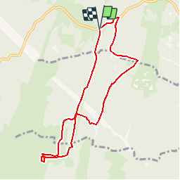
![](/images/other/stat-length.png)
![Tour Schneeschuhwandern Valserhône - Croix de Montlhéry - Photo](https://media.geolcdn.com/t/1900/400/ext.pjpeg?maxdim=2&url=https%3A%2F%2Fstatic1.geolcdn.com%2Fsiteimages%2Fupload%2Ffiles%2F1524743153raquette.jpg)
Croix de Montlhéry
ajpbm
Benutzer
![Länge](/images/other/stat-length.png)
![Maximale Höhe](https://static1.geolcdn.com/siteimages/upload/files/1508320355ic_sort_altitude_max_24dp.png)
![Positive Höhendifferenz](https://static1.geolcdn.com/siteimages/upload/files/1508320355ic_sort_den_pos_24dp.png)
![Km-Effort](/images/other/stat-length.png)
![Min. Höhe](https://static1.geolcdn.com/siteimages/upload/files/1508320355ic_sort_altitude_min_24dp.png)
![Negative Höhendifferenz](https://static1.geolcdn.com/siteimages/upload/files/1508320355ic_sort_den_neg_24dp.png)
![Boucle](https://static1.geolcdn.com/siteimages/upload/files/16400158638029165_repeat_loop_refresh_sync_direction_icon.png)
![Schneeschuhwandern](https://static1.geolcdn.com/sitytour/trail-icons/504.png)
4h00
Schwierigkeit : Unbekannt
![Scannen Sie diesen QR-Code, um die Tour in der SityTrail-Anwendung zu öffnen](https://capi.geolives.com/qq0zvz2zws4bq2lad0pu/sitytour/trails/887616/qr.png?size=200)
Kostenlosegpshiking-Anwendung
Über SityTrail
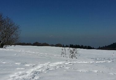
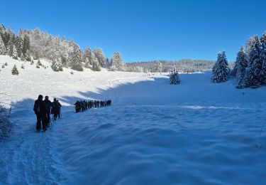
Tour Schneeschuhwandern von 8,3 km verfügbar auf Auvergne-Rhone-Alpen, Ain, Valserhône. Diese Tour wird von ajpbm vorgeschlagen.
Beschreibung
Stationner sur le grand Parking près du Col de Cuvery à 1178m, sur la
D101 qui permet d'accéder au Plateau de Retord depuis Bellegarde sur
Valserine.
Partir sud sur l'itinéraire balisé en direction de la Ferme du Retord. On va
ainsi parcourir la combe Maty puis la combe Martin et passer sous la ligne
HT
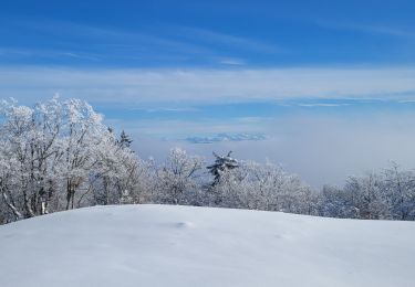
(1) À la ferme du Retord, repérer la Croix métallique de Montlhéry elle est
dans la direction Nord Est.
Gagner la croix à l'altitude 1321m.
(2) Prendre la direction Nord dans les bois en s'écartant des itinéraires
balisés. Puis prendre Est lorsque l'on approche de la ligne HT. L'idée est de
croiser l'itinéraire (3) de l'aller peu avant la ligne HT et de prendre la piste qui
conduit aux chalets de Pra Devant.
(4) À partir des chalets, prendre nord en marchant à côté de la piste de ski
de fond, cette fois on va passer sous la ligne HT.
(5) Vers le point 1231, à la sortie d'une clairière s'écarter par la droite de la
piste de ski de fond, le sentier va ainsi progresser Nord-Est jusqu'au lieu-dit
Le Jay (construction).
(6) Peu avant les bâtiments prendre un sentier qui part à gauche et progresser Ouest. Les intersections sont nombreuses, les traces
également, et il est facile de dévier de son cap, mais normalement on retrouve le point de départ, au pire on peut arriver sur la route (7
)qui faudra suivre alors en partant à gauche.
Ort
Kommentare
Touren in der Umgebung
![Tour Wandern Le Poizat-Lalleyriat - Le poizat - Photo](https://media.geolcdn.com/t/375/260/ext.jpg?maxdim=2&url=https%3A%2F%2Fmedia.geolcdn.com%2Ff%2F7adcfb78-7e0f-4282-8088-f8a2aad6cc8d.jpg)
![Wandern Wandern](https://static1.geolcdn.com/sitytour/trail-icons/101.png)
Wandern
![](/images/other/stat-length.png)
![](https://static1.geolcdn.com/siteimages/upload/files/16400158638029165_repeat_loop_refresh_sync_direction_icon.png)
![Tour Schneeschuhwandern Haut Valromey - la chapelle la CIA merlogne - Photo](https://media.geolcdn.com/t/375/260/ext.jpg?maxdim=2&url=https%3A%2F%2Fmedia.geolcdn.com%2Ff%2F6e74b7e6-14e7-4724-aa23-fda56c0a48ef.jpg)
![Schneeschuhwandern Schneeschuhwandern](https://static1.geolcdn.com/sitytour/trail-icons/504.png)
Schneeschuhwandern
![](/images/other/stat-length.png)
![](https://static1.geolcdn.com/siteimages/upload/files/16400158638029165_repeat_loop_refresh_sync_direction_icon.png)
![Tour Schneeschuhwandern Haut Valromey - raquettes chapelle5km6 - Photo](https://media.geolcdn.com/t/375/260/ext.jpg?maxdim=2&url=https%3A%2F%2Fmedia.geolcdn.com%2Ff%2F5c5fe89c-f0bd-42a9-b64e-5a89dfaa4209.jpg)
![Schneeschuhwandern Schneeschuhwandern](https://static1.geolcdn.com/sitytour/trail-icons/504.png)
Schneeschuhwandern
![](/images/other/stat-length.png)
![](https://static1.geolcdn.com/siteimages/upload/files/16400158638029165_repeat_loop_refresh_sync_direction_icon.png)
![Tour Wandern Valserhône - Cuvéry - Photo](https://media.geolcdn.com/t/375/260/ext.jpg?maxdim=2&url=https%3A%2F%2Fstatic1.geolcdn.com%2Fsiteimages%2Fupload%2Ffiles%2F1553511878bg_sport_marche.png)
![Wandern Wandern](https://static1.geolcdn.com/sitytour/trail-icons/101.png)
Wandern
![](/images/other/stat-length.png)
![](https://static1.geolcdn.com/siteimages/upload/files/16400158638029165_repeat_loop_refresh_sync_direction_icon.png)
![Tour Schneeschuhwandern Valserhône - Le retord - Photo](https://media.geolcdn.com/t/375/260/ext.jpg?maxdim=2&url=https%3A%2F%2Fservices.sitytrail.com%2FGeolivesWS%2FDownloadMedia.ashx%3FTrailID%3D255934%26Media%3Dfix__20140309151102.jpg)
![Schneeschuhwandern Schneeschuhwandern](https://static1.geolcdn.com/sitytour/trail-icons/504.png)
Schneeschuhwandern
![](/images/other/stat-length.png)
![](https://static1.geolcdn.com/siteimages/upload/files/16400158638029165_repeat_loop_refresh_sync_direction_icon.png)
![Tour Schneeschuhwandern Haut Valromey - raquettes la chapelle de retort croix de montlery - Photo](https://media.geolcdn.com/t/375/260/ext.jpg?maxdim=2&url=https%3A%2F%2Fmedia.geolcdn.com%2Ff%2Fbcb8c196-7620-4f27-b4e8-a21568349fd5.jpg)
![Schneeschuhwandern Schneeschuhwandern](https://static1.geolcdn.com/sitytour/trail-icons/504.png)
Schneeschuhwandern
![](/images/other/stat-length.png)
![](https://static1.geolcdn.com/siteimages/upload/files/16400158638029165_repeat_loop_refresh_sync_direction_icon.png)
![Tour Wandern Billiat - GTJ 12 Ferme de Retord/Chalet d'Arviere - Photo](https://media.geolcdn.com/t/375/260/ext.jpg?maxdim=2&url=https%3A%2F%2Fmedia.geolcdn.com%2Ff%2F61a28d07-b50d-4f8e-a461-33b463dff8c4.jpg)
![Wandern Wandern](https://static1.geolcdn.com/sitytour/trail-icons/101.png)
Wandern
![](/images/other/stat-length.png)
![](https://static1.geolcdn.com/siteimages/upload/files/16400158638029165_repeat_loop_refresh_sync_direction_icon.png)
![Tour Schneeschuhwandern Haut Valromey - La Manche La Cua Merlogne - Photo](https://media.geolcdn.com/t/375/260/ext.jpg?maxdim=2&url=https%3A%2F%2Fmedia.geolcdn.com%2Ff%2F20880140-2725-42ed-8fbc-73882d0f82b4.jpg)
![Schneeschuhwandern Schneeschuhwandern](https://static1.geolcdn.com/sitytour/trail-icons/504.png)
Schneeschuhwandern
![](/images/other/stat-length.png)
![](https://static1.geolcdn.com/siteimages/upload/files/16400158638029165_repeat_loop_refresh_sync_direction_icon.png)
![Tour Wandern Le Poizat-Lalleyriat - lalleyriat - Photo](https://media.geolcdn.com/t/375/260/ext.jpg?maxdim=2&url=https%3A%2F%2Fmedia.geolcdn.com%2Ff%2F0c331dbe-8893-4314-93e7-9ed9971d9ec6.jpg)
![Wandern Wandern](https://static1.geolcdn.com/sitytour/trail-icons/101.png)
Wandern
![](/images/other/stat-length.png)
![](https://static1.geolcdn.com/siteimages/upload/files/16400158638029165_repeat_loop_refresh_sync_direction_icon.png)