![](/images/other/stat-length.png)
![Tour Wandern Grandchamp-des-Fontaines - Grandchamps-des-Fontaines - Circuit des étangs - Photo](https://media.geolcdn.com/t/1900/400/ext.pjpeg?maxdim=2&url=https%3A%2F%2Fstatic1.geolcdn.com%2Fsiteimages%2Fupload%2Ffiles%2F1553511878bg_sport_marche.png)
Grandchamps-des-Fontaines - Circuit des étangs
TEFFRA
Benutzer
![Länge](/images/other/stat-length.png)
Länge
9,4 km
![Maximale Höhe](https://static1.geolcdn.com/siteimages/upload/files/1508320355ic_sort_altitude_max_24dp.png)
Maximale Höhe
47 m
![Positive Höhendifferenz](https://static1.geolcdn.com/siteimages/upload/files/1508320355ic_sort_den_pos_24dp.png)
Positive Höhendifferenz
69 m
![Km-Effort](/images/other/stat-length.png)
Km-Effort
10,3 km
![Min. Höhe](https://static1.geolcdn.com/siteimages/upload/files/1508320355ic_sort_altitude_min_24dp.png)
Min. Höhe
24 m
![Negative Höhendifferenz](https://static1.geolcdn.com/siteimages/upload/files/1508320355ic_sort_den_neg_24dp.png)
Negative Höhendifferenz
69 m
![Boucle](https://static1.geolcdn.com/siteimages/upload/files/16400158638029165_repeat_loop_refresh_sync_direction_icon.png)
Boucle
Ja
Erstellungsdatum :
2018-04-17 14:39:49.779
Letzte Änderung :
2018-04-17 14:39:49.779
![Wandern](https://static1.geolcdn.com/sitytour/trail-icons/101.png)
2h17
Schwierigkeit : Einfach
![Scannen Sie diesen QR-Code, um die Tour in der SityTrail-Anwendung zu öffnen](https://capi.geolives.com/qq0zvz2zws4bq2lad0pu/sitytour/trails/875987/qr.png?size=200)
Kostenlosegpshiking-Anwendung
Über SityTrail
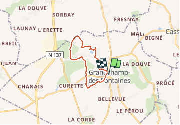
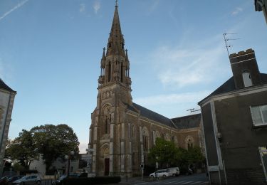
Tour Wandern von 9,4 km verfügbar auf Pays de la Loire, Loire-Atlantique, Grandchamp-des-Fontaines. Diese Tour wird von TEFFRA vorgeschlagen.
Beschreibung
Point de RDV parking avenue du Général De Gaulle Venant de Nantes à gauche après l'église et la pharmacie
Ort
Land:
France
Region :
Pays de la Loire
Abteilung/Provinz :
Loire-Atlantique
Kommune :
Grandchamp-des-Fontaines
Standort:
Unknown
Gehen Sie:(Dec)
Gehen Sie:(UTM)
605248 ; 5246768 (30T) N.
Kommentare
Touren in der Umgebung
![Tour Wandern Casson - Circuit des chemins creux - Casson - Photo](https://media.geolcdn.com/t/375/260/ext.jpg?maxdim=2&url=https%3A%2F%2Fservices.sitytrail.com%2FGeolivesWS%2FDownloadMedia.ashx%3FTrailID%3D112353%26Media%3D10435_4.jpg)
![Wandern Wandern](https://static1.geolcdn.com/sitytour/trail-icons/101.png)
Circuit des chemins creux - Casson
Wandern
Schwierig
(1)
Casson,
Pays de la Loire,
Loire-Atlantique,
France
![](/images/other/stat-length.png)
15,7 km | 17,3 km-effort
3h 55min
![](https://static1.geolcdn.com/siteimages/upload/files/16400158638029165_repeat_loop_refresh_sync_direction_icon.png)
Ja
![Tour Wandern Grandchamp-des-Fontaines - Circuit](https://media.geolcdn.com/t/375/260/ext.jpg?maxdim=2&url=https%3A%2F%2Fservices.sitytrail.com%2FGeolivesWS%2FDownloadMedia.ashx%3FTrailID%3D342053%26Media%3Df8e20a34-780d-4fd0-bdda-ef7d21eaaf41.jpg)
![Wandern Wandern](https://static1.geolcdn.com/sitytour/trail-icons/101.png)
Circuit "Les Moulins" - GRANDCHAMP-DES-FONTAINES
Wandern
Sehr leicht
(1)
Grandchamp-des-Fontaines,
Pays de la Loire,
Loire-Atlantique,
France
![](/images/other/stat-length.png)
13,8 km | 15,5 km-effort
4h 2min
![](https://static1.geolcdn.com/siteimages/upload/files/16400158638029165_repeat_loop_refresh_sync_direction_icon.png)
Ja
![Tour Zu Fuß Treillières - La Vallée du Gesvres - Photo](https://media.geolcdn.com/t/375/260/8559773a-c69a-4cdf-aa57-f4164f184ec9.jpeg&format=jpg&maxdim=2)
![Zu Fuß Zu Fuß](https://static1.geolcdn.com/sitytour/trail-icons/100.png)
La Vallée du Gesvres
Zu Fuß
Einfach
Treillières,
Pays de la Loire,
Loire-Atlantique,
France
![](/images/other/stat-length.png)
8,7 km | 10,1 km-effort
2h 18min
![](https://static1.geolcdn.com/siteimages/upload/files/16400158638029165_repeat_loop_refresh_sync_direction_icon.png)
Nein
![Tour Zu Fuß Casson - Les chemins creux - Photo](https://media.geolcdn.com/t/375/260/162fadad-0288-4e89-a48a-1468248d0ca5.jpeg&format=jpg&maxdim=2)
![Zu Fuß Zu Fuß](https://static1.geolcdn.com/sitytour/trail-icons/100.png)
Les chemins creux
Zu Fuß
Einfach
Casson,
Pays de la Loire,
Loire-Atlantique,
France
![](/images/other/stat-length.png)
16,4 km | 18,3 km-effort
4h 8min
![](https://static1.geolcdn.com/siteimages/upload/files/16400158638029165_repeat_loop_refresh_sync_direction_icon.png)
Ja
![Tour Rennrad Casson - TLA Etape 2 complète 152 km - Photo](https://media.geolcdn.com/t/375/260/ext.jpg?maxdim=2&url=https%3A%2F%2Fstatic1.geolcdn.com%2Fsiteimages%2Fupload%2Ffiles%2F1524743154velo.jpg)
![Rennrad Rennrad](https://static1.geolcdn.com/sitytour/trail-icons/201.png)
TLA Etape 2 complète 152 km
Rennrad
Schwierig
(1)
Casson,
Pays de la Loire,
Loire-Atlantique,
France
![](/images/other/stat-length.png)
152 km | 173 km-effort
4h 10min
![](https://static1.geolcdn.com/siteimages/upload/files/16400158638029165_repeat_loop_refresh_sync_direction_icon.png)
Nein
![Tour Zu Fuß Grandchamp-des-Fontaines - Les Étangs - Photo](https://media.geolcdn.com/t/375/260/85b0be42-6194-4514-a1ed-f643872657fd.jpeg&format=jpg&maxdim=2)
![Zu Fuß Zu Fuß](https://static1.geolcdn.com/sitytour/trail-icons/100.png)
Les Étangs
Zu Fuß
Einfach
Grandchamp-des-Fontaines,
Pays de la Loire,
Loire-Atlantique,
France
![](/images/other/stat-length.png)
9,1 km | 10 km-effort
2h 15min
![](https://static1.geolcdn.com/siteimages/upload/files/16400158638029165_repeat_loop_refresh_sync_direction_icon.png)
Ja
![Tour Pferd Casson - Circuit des chemins creux - Casson - Photo](https://media.geolcdn.com/t/375/260/ext.jpg?maxdim=2&url=https%3A%2F%2Fservices.sitytrail.com%2FGeolivesWS%2FDownloadMedia.ashx%3FTrailID%3D112355%26Media%3D10435_4.jpg)
![Pferd Pferd](https://static1.geolcdn.com/sitytour/trail-icons/300.png)
Circuit des chemins creux - Casson
Pferd
Medium
Casson,
Pays de la Loire,
Loire-Atlantique,
France
![](/images/other/stat-length.png)
15,7 km | 17,3 km-effort
2h 15min
![](https://static1.geolcdn.com/siteimages/upload/files/16400158638029165_repeat_loop_refresh_sync_direction_icon.png)
Ja
![Tour Mountainbike Casson - Circuit des chemins creux - Casson - Photo](https://media.geolcdn.com/t/375/260/ext.jpg?maxdim=2&url=https%3A%2F%2Fservices.sitytrail.com%2FGeolivesWS%2FDownloadMedia.ashx%3FTrailID%3D112354%26Media%3D10435_4.jpg)
![Mountainbike Mountainbike](https://static1.geolcdn.com/sitytour/trail-icons/202.png)
Circuit des chemins creux - Casson
Mountainbike
Einfach
Casson,
Pays de la Loire,
Loire-Atlantique,
France
![](/images/other/stat-length.png)
15,7 km | 17,3 km-effort
1h 15min
![](https://static1.geolcdn.com/siteimages/upload/files/16400158638029165_repeat_loop_refresh_sync_direction_icon.png)
Ja
![Tour Wandern Treillières - 2010-08-03 - 16h42m56 - Photo](https://media.geolcdn.com/t/375/260/ext.jpg?maxdim=2&url=https%3A%2F%2Fservices.sitytrail.com%2FGeolivesWS%2FDownloadMedia.ashx%3FTrailID%3D42883%26Media%3Dimage3.jpg)
![Wandern Wandern](https://static1.geolcdn.com/sitytour/trail-icons/101.png)
2010-08-03 - 16h42m56
Wandern
Sehr leicht
Treillières,
Pays de la Loire,
Loire-Atlantique,
France
![](/images/other/stat-length.png)
745 km | 1181 km-effort
Unbekannt
![](https://static1.geolcdn.com/siteimages/upload/files/16400158638029165_repeat_loop_refresh_sync_direction_icon.png)
Nein