![](/images/other/stat-length.png)
![Tour Wandern Mont-Dore - AUVERGNE - PUY de SANCY - Photo](https://media.geolcdn.com/t/1900/400/ext.pjpeg?maxdim=2&url=https%3A%2F%2Fstatic1.geolcdn.com%2Fsiteimages%2Fupload%2Ffiles%2F1553511878bg_sport_marche.png)
AUVERGNE - PUY de SANCY
ffffff
Benutzer
![Länge](/images/other/stat-length.png)
Länge
17,7 km
![Maximale Höhe](https://static1.geolcdn.com/siteimages/upload/files/1508320355ic_sort_altitude_max_24dp.png)
Maximale Höhe
1862 m
![Positive Höhendifferenz](https://static1.geolcdn.com/siteimages/upload/files/1508320355ic_sort_den_pos_24dp.png)
Positive Höhendifferenz
1021 m
![Km-Effort](/images/other/stat-length.png)
Km-Effort
31 km
![Min. Höhe](https://static1.geolcdn.com/siteimages/upload/files/1508320355ic_sort_altitude_min_24dp.png)
Min. Höhe
1045 m
![Negative Höhendifferenz](https://static1.geolcdn.com/siteimages/upload/files/1508320355ic_sort_den_neg_24dp.png)
Negative Höhendifferenz
1019 m
![Boucle](https://static1.geolcdn.com/siteimages/upload/files/16400158638029165_repeat_loop_refresh_sync_direction_icon.png)
Boucle
Ja
Erstellungsdatum :
2018-04-16 23:36:05.277
Letzte Änderung :
2018-04-16 23:36:05.277
![Wandern](https://static1.geolcdn.com/sitytour/trail-icons/101.png)
5h31
Schwierigkeit : Medium
![Scannen Sie diesen QR-Code, um die Tour in der SityTrail-Anwendung zu öffnen](https://capi.geolives.com/qq0zvz2zws4bq2lad0pu/sitytour/trails/836249/qr.png?size=200)
Kostenlosegpshiking-Anwendung
Über SityTrail
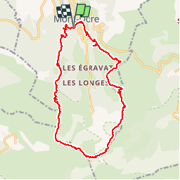
Tour Wandern von 17,7 km verfügbar auf Auvergne-Rhone-Alpen, Puy-de-Dôme, Mont-Dore. Diese Tour wird von ffffff vorgeschlagen.
Beschreibung
montée, depuis les thermes du Mont Dore, par la grande cascade, par le Puy des Crebasses, et, après le Puy de SANCY, descente par le Puy de Cliergue.
Aucune difficulté technique. Rando faite par des "moyens marcheurs".
Ort
Land:
France
Region :
Auvergne-Rhone-Alpen
Abteilung/Provinz :
Puy-de-Dôme
Kommune :
Mont-Dore
Standort:
Unknown
Gehen Sie:(Dec)
Gehen Sie:(UTM)
485045 ; 5046564 (31T) N.
Kommentare
Touren in der Umgebung
![Tour Wandern Mont-Dore - Montée au sommet du Puy de Sancy - Photo](https://media.geolcdn.com/t/375/260/1486ae36-afa6-41d3-a8cf-03841ddf3ad3.jpg&format=jpg&maxdim=2)
![Wandern Wandern](https://static1.geolcdn.com/sitytour/trail-icons/101.png)
Montée au sommet du Puy de Sancy
Wandern
Einfach
(1)
Mont-Dore,
Auvergne-Rhone-Alpen,
Puy-de-Dôme,
France
![](/images/other/stat-length.png)
1,4 km | 2,7 km-effort
40min
![](https://static1.geolcdn.com/siteimages/upload/files/16400158638029165_repeat_loop_refresh_sync_direction_icon.png)
Ja
![Tour Wandern Murat-le-Quaire - De Murat le Quaire au Puy Gros - Photo](https://media.geolcdn.com/t/375/260/ext.jpg?maxdim=2&url=https%3A%2F%2Fservices.sitytrail.com%2FGeolivesWS%2FDownloadMedia.ashx%3FTrailID%3D173047%26Media%3D14567_5.jpg)
![Wandern Wandern](https://static1.geolcdn.com/sitytour/trail-icons/101.png)
De Murat le Quaire au Puy Gros
Wandern
Medium
(3)
Murat-le-Quaire,
Auvergne-Rhone-Alpen,
Puy-de-Dôme,
France
![](/images/other/stat-length.png)
13,5 km | 21 km-effort
4h 19min
![](https://static1.geolcdn.com/siteimages/upload/files/16400158638029165_repeat_loop_refresh_sync_direction_icon.png)
Ja
![Wandern Wandern](https://static1.geolcdn.com/sitytour/trail-icons/101.png)
Mont_Dore_Puy_Sancy
Wandern
Schwierig
(1)
Mont-Dore,
Auvergne-Rhone-Alpen,
Puy-de-Dôme,
France
![](/images/other/stat-length.png)
6,8 km | 13,9 km-effort
2h 0min
![](https://static1.geolcdn.com/siteimages/upload/files/16400158638029165_repeat_loop_refresh_sync_direction_icon.png)
Ja
![Wandern Wandern](https://static1.geolcdn.com/sitytour/trail-icons/101.png)
Chambon_Vallee_Chaudefour_2
Wandern
Schwierig
(1)
Chambon-sur-Lac,
Auvergne-Rhone-Alpen,
Puy-de-Dôme,
France
![](/images/other/stat-length.png)
15 km | 26 km-effort
4h 30min
![](https://static1.geolcdn.com/siteimages/upload/files/16400158638029165_repeat_loop_refresh_sync_direction_icon.png)
Ja
![Tour Wandern Murat-le-Quaire - Murat_Quaire_Ordanche - Photo](https://media.geolcdn.com/t/375/260/b09d93ea-88df-4f42-8ffa-b565d95a8b44.jpg&format=jpg&maxdim=2)
![Wandern Wandern](https://static1.geolcdn.com/sitytour/trail-icons/101.png)
Murat_Quaire_Ordanche
Wandern
Medium
(2)
Murat-le-Quaire,
Auvergne-Rhone-Alpen,
Puy-de-Dôme,
France
![](/images/other/stat-length.png)
8,1 km | 13,7 km-effort
2h 49min
![](https://static1.geolcdn.com/siteimages/upload/files/16400158638029165_repeat_loop_refresh_sync_direction_icon.png)
Ja
![Tour Wandern Mont-Dore - Le puy de la tache, le lacs servières et guèry par la cascade du Queureuilh depuis l'Escalidou. - Photo](https://media.geolcdn.com/t/375/260/ext.jpg?maxdim=2&url=https%3A%2F%2Fservices.sitytrail.com%2FGeolivesWS%2FDownloadMedia.ashx%3FTrailID%3D228422%26Media%3D20131022164253.jpg)
![Wandern Wandern](https://static1.geolcdn.com/sitytour/trail-icons/101.png)
Le puy de la tache, le lacs servières et guèry par la cascade du Queureuilh d...
Wandern
Schwierig
(3)
Mont-Dore,
Auvergne-Rhone-Alpen,
Puy-de-Dôme,
France
![](/images/other/stat-length.png)
34 km | 50 km-effort
10h 16min
![](https://static1.geolcdn.com/siteimages/upload/files/16400158638029165_repeat_loop_refresh_sync_direction_icon.png)
Ja
![Tour Wandern Mont-Dore - le sancy du mont dore par le côté ouest puis revenir par le côté est. - Photo](https://media.geolcdn.com/t/375/260/ext.jpg?maxdim=2&url=https%3A%2F%2Fservices.sitytrail.com%2FGeolivesWS%2FDownloadMedia.ashx%3FTrailID%3D228300%26Media%3D20131021153021.jpg)
![Wandern Wandern](https://static1.geolcdn.com/sitytour/trail-icons/101.png)
le sancy du mont dore par le côté ouest puis revenir par le côté est.
Wandern
Schwierig
(2)
Mont-Dore,
Auvergne-Rhone-Alpen,
Puy-de-Dôme,
France
![](/images/other/stat-length.png)
8,2 km | 15,4 km-effort
3h 5min
![](https://static1.geolcdn.com/siteimages/upload/files/16400158638029165_repeat_loop_refresh_sync_direction_icon.png)
Ja
![Tour Wandern Murat-le-Quaire - La Banne d'Ordanche - Photo](https://media.geolcdn.com/t/375/260/ext.jpg?maxdim=2&url=https%3A%2F%2Fservices.sitytrail.com%2FGeolivesWS%2FDownloadMedia.ashx%3FTrailID%3D147717%26Media%3D20120817123608.jpg)
![Wandern Wandern](https://static1.geolcdn.com/sitytour/trail-icons/101.png)
La Banne d'Ordanche
Wandern
Medium
(2)
Murat-le-Quaire,
Auvergne-Rhone-Alpen,
Puy-de-Dôme,
France
![](/images/other/stat-length.png)
9,2 km | 15 km-effort
3h 29min
![](https://static1.geolcdn.com/siteimages/upload/files/16400158638029165_repeat_loop_refresh_sync_direction_icon.png)
Ja
![Tour Wandern Mont-Dore - Sentier des crêtes Puy de Sancy - Photo](https://media.geolcdn.com/t/375/260/ext.jpg?maxdim=2&url=https%3A%2F%2Fservices.sitytrail.com%2FGeolivesWS%2FDownloadMedia.ashx%3FTrailID%3D106861%26Media%3D11600_5.jpg)
![Wandern Wandern](https://static1.geolcdn.com/sitytour/trail-icons/101.png)
Sentier des crêtes Puy de Sancy
Wandern
Schwierig
(2)
Mont-Dore,
Auvergne-Rhone-Alpen,
Puy-de-Dôme,
France
![](/images/other/stat-length.png)
26 km | 46 km-effort
9h 0min
![](https://static1.geolcdn.com/siteimages/upload/files/16400158638029165_repeat_loop_refresh_sync_direction_icon.png)
Ja