![](/images/other/stat-length.png)
![Tour Wandern Nesles-la-Vallée - GR1 De Nesles-la-Vallée (Val-d'Oise) à Crécy-la-Chapelle (Seine-et-Marne) - Photo](https://media.geolcdn.com/t/1900/400/ext.pjpeg?maxdim=2&url=https%3A%2F%2Fstatic1.geolcdn.com%2Fsiteimages%2Fupload%2Ffiles%2F1553511878bg_sport_marche.png)
GR1 De Nesles-la-Vallée (Val-d'Oise) à Crécy-la-Chapelle (Seine-et-Marne)
lasvergn
Benutzer
![Länge](/images/other/stat-length.png)
Länge
122 km
![Maximale Höhe](https://static1.geolcdn.com/siteimages/upload/files/1508320355ic_sort_altitude_max_24dp.png)
Maximale Höhe
218 m
![Positive Höhendifferenz](https://static1.geolcdn.com/siteimages/upload/files/1508320355ic_sort_den_pos_24dp.png)
Positive Höhendifferenz
1909 m
![Km-Effort](/images/other/stat-length.png)
Km-Effort
147 km
![Min. Höhe](https://static1.geolcdn.com/siteimages/upload/files/1508320355ic_sort_altitude_min_24dp.png)
Min. Höhe
22 m
![Negative Höhendifferenz](https://static1.geolcdn.com/siteimages/upload/files/1508320355ic_sort_den_neg_24dp.png)
Negative Höhendifferenz
1899 m
![Boucle](https://static1.geolcdn.com/siteimages/upload/files/16400158638029165_repeat_loop_refresh_sync_direction_icon.png)
Boucle
Nein
Erstellungsdatum :
2018-04-16 23:28:54.019
Letzte Änderung :
2018-04-16 23:28:54.019
![Wandern](https://static1.geolcdn.com/sitytour/trail-icons/101.png)
30h25
Schwierigkeit : Schwierig
![Scannen Sie diesen QR-Code, um die Tour in der SityTrail-Anwendung zu öffnen](https://capi.geolives.com/qq0zvz2zws4bq2lad0pu/sitytour/trails/835101/qr.png?size=200)
Kostenlosegpshiking-Anwendung
Über SityTrail
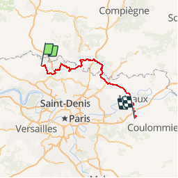
Tour Wandern von 122 km verfügbar auf Île-de-France, Val-d'Oise, Nesles-la-Vallée. Diese Tour wird von lasvergn vorgeschlagen.
Beschreibung
Randonnée avec le GR1 autour de Paris par le Val-d'Oise, l'Oise et la Seine-et-Marne de Nesles-la-Vallée à Crécy-la-Chapelle.
Ort
Land:
France
Region :
Île-de-France
Abteilung/Provinz :
Val-d'Oise
Kommune :
Nesles-la-Vallée
Standort:
Unknown
Gehen Sie:(Dec)
Gehen Sie:(UTM)
439472 ; 5442069 (31U) N.
Kommentare
Touren in der Umgebung
![Tour Wandern Parmain - L Parmain jean Sarment a Valmondoit - Photo](https://media.geolcdn.com/t/375/260/ext.jpg?maxdim=2&url=https%3A%2F%2Fmedia.geolcdn.com%2Ff%2Ff077cbce-67ad-4318-aa64-96311b6a86ee.jpg)
![Wandern Wandern](https://static1.geolcdn.com/sitytour/trail-icons/101.png)
L Parmain jean Sarment a Valmondoit
Wandern
Sehr leicht
(1)
Parmain,
Île-de-France,
Val-d'Oise,
France
![](/images/other/stat-length.png)
7,9 km | 9,5 km-effort
2h 10min
![](https://static1.geolcdn.com/siteimages/upload/files/16400158638029165_repeat_loop_refresh_sync_direction_icon.png)
Ja
![Tour Wandern Menouville - De Ménouville à Ronquerolles - Photo](https://media.geolcdn.com/t/375/260/ext.jpg?maxdim=2&url=https%3A%2F%2Fservices.sitytrail.com%2FGeolivesWS%2FDownloadMedia.ashx%3FTrailID%3D110227%26Media%3D5495_1.jpg)
![Wandern Wandern](https://static1.geolcdn.com/sitytour/trail-icons/101.png)
De Ménouville à Ronquerolles
Wandern
Schwierig
(2)
Menouville,
Île-de-France,
Val-d'Oise,
France
![](/images/other/stat-length.png)
24 km | 30 km-effort
5h 0min
![](https://static1.geolcdn.com/siteimages/upload/files/16400158638029165_repeat_loop_refresh_sync_direction_icon.png)
Ja
![Tour Wandern L'Isle-Adam - Autour de l'Isle Adam - Photo](https://media.geolcdn.com/t/375/260/ext.jpg?maxdim=2&url=https%3A%2F%2Fservices.sitytrail.com%2FGeolivesWS%2FDownloadMedia.ashx%3FTrailID%3D110076%26Media%3D5235_1.jpg)
![Wandern Wandern](https://static1.geolcdn.com/sitytour/trail-icons/101.png)
Autour de l'Isle Adam
Wandern
Schwierig
(1)
L'Isle-Adam,
Île-de-France,
Val-d'Oise,
France
![](/images/other/stat-length.png)
22 km | 26 km-effort
4h 30min
![](https://static1.geolcdn.com/siteimages/upload/files/16400158638029165_repeat_loop_refresh_sync_direction_icon.png)
Ja
![Tour Wandern Valmondois - Vallée de Nesles - Photo](https://media.geolcdn.com/t/375/260/ext.jpg?maxdim=2&url=https%3A%2F%2Fservices.sitytrail.com%2FGeolivesWS%2FDownloadMedia.ashx%3FTrailID%3D110075%26Media%3D5234_1.jpg)
![Wandern Wandern](https://static1.geolcdn.com/sitytour/trail-icons/101.png)
Vallée de Nesles
Wandern
Schwierig
(1)
Valmondois,
Île-de-France,
Val-d'Oise,
France
![](/images/other/stat-length.png)
23 km | 28 km-effort
4h 45min
![](https://static1.geolcdn.com/siteimages/upload/files/16400158638029165_repeat_loop_refresh_sync_direction_icon.png)
Ja
![Tour Zu Fuß L'Isle-Adam - L'Isle-Adam 02 L'Isle Adam - Photo](https://media.geolcdn.com/t/375/260/ext.jpg?maxdim=2&url=https%3A%2F%2Fstatic1.geolcdn.com%2Fsiteimages%2Fupload%2Ffiles%2F1545311037marcheuse_200dpi.jpg)
![Zu Fuß Zu Fuß](https://static1.geolcdn.com/sitytour/trail-icons/100.png)
L'Isle-Adam 02 L'Isle Adam
Zu Fuß
Sehr leicht
(1)
L'Isle-Adam,
Île-de-France,
Val-d'Oise,
France
![](/images/other/stat-length.png)
9,4 km | 10,7 km-effort
3h 0min
![](https://static1.geolcdn.com/siteimages/upload/files/16400158638029165_repeat_loop_refresh_sync_direction_icon.png)
Ja
![Tour Wandern Champagne-sur-Oise - Autour de Parmain - Photo](https://media.geolcdn.com/t/375/260/ext.jpg?maxdim=2&url=https%3A%2F%2Fstatic1.geolcdn.com%2Fsiteimages%2Fupload%2Ffiles%2F1553511878bg_sport_marche.png)
![Wandern Wandern](https://static1.geolcdn.com/sitytour/trail-icons/101.png)
Autour de Parmain
Wandern
Medium
(1)
Champagne-sur-Oise,
Île-de-France,
Val-d'Oise,
France
![](/images/other/stat-length.png)
18,9 km | 23 km-effort
4h 0min
![](https://static1.geolcdn.com/siteimages/upload/files/16400158638029165_repeat_loop_refresh_sync_direction_icon.png)
Nein
![Tour Wandern Labbeville - labeville vallongoujard wmezieres - Photo](https://media.geolcdn.com/t/375/260/ext.jpg?maxdim=2&url=https%3A%2F%2Fmedia.geolcdn.com%2Ff%2F106f1333-5f77-4ccf-971e-c03e39d67737.jpg)
![Wandern Wandern](https://static1.geolcdn.com/sitytour/trail-icons/101.png)
labeville vallongoujard wmezieres
Wandern
Einfach
Labbeville,
Île-de-France,
Val-d'Oise,
France
![](/images/other/stat-length.png)
11,1 km | 13,1 km-effort
3h 8min
![](https://static1.geolcdn.com/siteimages/upload/files/16400158638029165_repeat_loop_refresh_sync_direction_icon.png)
Ja
![Tour Wandern Champagne-sur-Oise - Vaux Chateaude Chambly Ronquerole - Photo](https://media.geolcdn.com/t/375/260/ext.jpg?maxdim=2&url=https%3A%2F%2Fmedia.geolcdn.com%2Ff%2Fcbee2e0f-c40e-40ad-a67b-eb4ac34cdc7c.jpg)
![Wandern Wandern](https://static1.geolcdn.com/sitytour/trail-icons/101.png)
Vaux Chateaude Chambly Ronquerole
Wandern
Einfach
Champagne-sur-Oise,
Île-de-France,
Val-d'Oise,
France
![](/images/other/stat-length.png)
10,6 km | 13,1 km-effort
2h 28min
![](https://static1.geolcdn.com/siteimages/upload/files/16400158638029165_repeat_loop_refresh_sync_direction_icon.png)
Ja
![Tour Wandern Valmondois - Valmondois Mesles - Photo](https://media.geolcdn.com/t/375/260/ext.jpg?maxdim=2&url=https%3A%2F%2Fmedia.geolcdn.com%2Ff%2F47035f7e-0b70-46b5-a0f2-a695d19358e8.jpg)
![Wandern Wandern](https://static1.geolcdn.com/sitytour/trail-icons/101.png)
Valmondois Mesles
Wandern
Einfach
Valmondois,
Île-de-France,
Val-d'Oise,
France
![](/images/other/stat-length.png)
11 km | 13,6 km-effort
2h 42min
![](https://static1.geolcdn.com/siteimages/upload/files/16400158638029165_repeat_loop_refresh_sync_direction_icon.png)
Ja