![](/images/other/stat-length.png)
![Tour Pferd Villeneuve-les-Cerfs - Sept 2017 - J2 - Autour des bois de Randan - Photo](https://media.geolcdn.com/t/1900/400/ext.pjpeg?maxdim=2&url=https%3A%2F%2Fstatic1.geolcdn.com%2Fsiteimages%2Fupload%2Ffiles%2F1524743154cheval.jpg)
Sept 2017 - J2 - Autour des bois de Randan
Maestria
Benutzer
![Länge](/images/other/stat-length.png)
Länge
33 km
![Maximale Höhe](https://static1.geolcdn.com/siteimages/upload/files/1508320355ic_sort_altitude_max_24dp.png)
Maximale Höhe
404 m
![Positive Höhendifferenz](https://static1.geolcdn.com/siteimages/upload/files/1508320355ic_sort_den_pos_24dp.png)
Positive Höhendifferenz
495 m
![Km-Effort](/images/other/stat-length.png)
Km-Effort
39 km
![Min. Höhe](https://static1.geolcdn.com/siteimages/upload/files/1508320355ic_sort_altitude_min_24dp.png)
Min. Höhe
313 m
![Negative Höhendifferenz](https://static1.geolcdn.com/siteimages/upload/files/1508320355ic_sort_den_neg_24dp.png)
Negative Höhendifferenz
497 m
![Boucle](https://static1.geolcdn.com/siteimages/upload/files/16400158638029165_repeat_loop_refresh_sync_direction_icon.png)
Boucle
Ja
Erstellungsdatum :
2018-04-16 22:18:57.542
Letzte Änderung :
2018-04-16 22:18:57.542
![Pferd](https://static1.geolcdn.com/sitytour/trail-icons/300.png)
4h53
Schwierigkeit : Einfach
![Scannen Sie diesen QR-Code, um die Tour in der SityTrail-Anwendung zu öffnen](https://capi.geolives.com/qq0zvz2zws4bq2lad0pu/sitytour/trails/823322/qr.png?size=200)
Kostenlosegpshiking-Anwendung
Über SityTrail
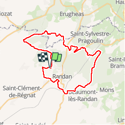
Tour Pferd von 33 km verfügbar auf Auvergne-Rhone-Alpen, Puy-de-Dôme, Villeneuve-les-Cerfs. Diese Tour wird von Maestria vorgeschlagen.
Beschreibung
Attention, la traversée des bois de Randan est interdite. Demander l'autorisation aux chasseurs d'Effiat (contacter le maire d'Effiat) et à Arborea à Vichy (gestionnaire des bois).
Ort
Land:
France
Region :
Auvergne-Rhone-Alpen
Abteilung/Provinz :
Puy-de-Dôme
Kommune :
Villeneuve-les-Cerfs
Standort:
Unknown
Gehen Sie:(Dec)
Gehen Sie:(UTM)
526098 ; 5096796 (31T) N.
Kommentare
Touren in der Umgebung
![Tour Zu Fuß Saint-Sylvestre-Pragoulin - Saint-Sylvestre-Pragoulin - Photo](https://media.geolcdn.com/t/375/260/e3638781-ca70-43ca-b2ba-983f3a189282.jpeg&format=jpg&maxdim=2)
![Zu Fuß Zu Fuß](https://static1.geolcdn.com/sitytour/trail-icons/100.png)
Saint-Sylvestre-Pragoulin
Zu Fuß
Einfach
Saint-Sylvestre-Pragoulin,
Auvergne-Rhone-Alpen,
Puy-de-Dôme,
France
![](/images/other/stat-length.png)
4,6 km | 5,9 km-effort
1h 19min
![](https://static1.geolcdn.com/siteimages/upload/files/16400158638029165_repeat_loop_refresh_sync_direction_icon.png)
Ja
![Tour Wandern Randan - randan - Photo](https://media.geolcdn.com/t/375/260/7ae88c40-cbdc-4e9e-9321-2d1271570f20.jpg&format=jpg&maxdim=2)
![Wandern Wandern](https://static1.geolcdn.com/sitytour/trail-icons/101.png)
randan
Wandern
Medium
Randan,
Auvergne-Rhone-Alpen,
Puy-de-Dôme,
France
![](/images/other/stat-length.png)
9 km | 11 km-effort
2h 56min
![](https://static1.geolcdn.com/siteimages/upload/files/16400158638029165_repeat_loop_refresh_sync_direction_icon.png)
Ja
![Tour Wandern Randan - Randan_Traces_Adelaide - Photo](https://media.geolcdn.com/t/375/260/cc536e91-8b46-42a5-b1b0-48a5ca879c1d.jpg&format=jpg&maxdim=2)
![Wandern Wandern](https://static1.geolcdn.com/sitytour/trail-icons/101.png)
Randan_Traces_Adelaide
Wandern
Einfach
Randan,
Auvergne-Rhone-Alpen,
Puy-de-Dôme,
France
![](/images/other/stat-length.png)
10,2 km | 12,1 km-effort
3h 0min
![](https://static1.geolcdn.com/siteimages/upload/files/16400158638029165_repeat_loop_refresh_sync_direction_icon.png)
Ja
![Tour Radtourismus Saint-Sylvestre-Pragoulin - Randan - Photo](https://media.geolcdn.com/t/375/260/ext.jpg?maxdim=2&url=https%3A%2F%2Fstatic1.geolcdn.com%2Fsiteimages%2Fupload%2Ffiles%2F1524743154velo.jpg)
![Radtourismus Radtourismus](https://static1.geolcdn.com/sitytour/trail-icons/204.png)
Randan
Radtourismus
Medium
Saint-Sylvestre-Pragoulin,
Auvergne-Rhone-Alpen,
Puy-de-Dôme,
France
![](/images/other/stat-length.png)
65 km | 75 km-effort
2h 52min
![](https://static1.geolcdn.com/siteimages/upload/files/16400158638029165_repeat_loop_refresh_sync_direction_icon.png)
Ja
![Tour Wandern Saint-Sylvestre-Pragoulin - La marche des chouettes - Photo](https://media.geolcdn.com/t/375/260/2d892dca-0a3d-4702-989b-5e5a626bef79.jpg&format=jpg&maxdim=2)
![Wandern Wandern](https://static1.geolcdn.com/sitytour/trail-icons/101.png)
La marche des chouettes
Wandern
Einfach
Saint-Sylvestre-Pragoulin,
Auvergne-Rhone-Alpen,
Puy-de-Dôme,
France
![](/images/other/stat-length.png)
25 km | 31 km-effort
5h 20min
![](https://static1.geolcdn.com/siteimages/upload/files/16400158638029165_repeat_loop_refresh_sync_direction_icon.png)
Ja
![Tour Wandern Randan - Randan - Photo](https://media.geolcdn.com/t/375/260/ext.jpg?maxdim=2&url=https%3A%2F%2Fstatic1.geolcdn.com%2Fsiteimages%2Fupload%2Ffiles%2F1553511878bg_sport_marche.png)
![Wandern Wandern](https://static1.geolcdn.com/sitytour/trail-icons/101.png)
Randan
Wandern
Medium
Randan,
Auvergne-Rhone-Alpen,
Puy-de-Dôme,
France
![](/images/other/stat-length.png)
9 km | 10,6 km-effort
2h 19min
![](https://static1.geolcdn.com/siteimages/upload/files/16400158638029165_repeat_loop_refresh_sync_direction_icon.png)
Ja
![Tour Mountainbike Villeneuve-les-Cerfs - beauregard - Photo](https://media.geolcdn.com/t/375/260/09d03eb3-ecc9-478e-9ee3-9ff63f71b48b.jpg&format=jpg&maxdim=2)
![Mountainbike Mountainbike](https://static1.geolcdn.com/sitytour/trail-icons/202.png)
beauregard
Mountainbike
Sehr leicht
Villeneuve-les-Cerfs,
Auvergne-Rhone-Alpen,
Puy-de-Dôme,
France
![](/images/other/stat-length.png)
2,9 km | 3,3 km-effort
14min
![](https://static1.geolcdn.com/siteimages/upload/files/16400158638029165_repeat_loop_refresh_sync_direction_icon.png)
Nein
![Tour Pferd Villeneuve-les-Cerfs - Sept 2017 - J1 Les Pioliers - Bois de Randan - Demolles - Les Pioliers - Photo](https://media.geolcdn.com/t/375/260/ext.jpg?maxdim=2&url=https%3A%2F%2Fstatic1.geolcdn.com%2Fsiteimages%2Fupload%2Ffiles%2F1524743154cheval.jpg)
![Pferd Pferd](https://static1.geolcdn.com/sitytour/trail-icons/300.png)
Sept 2017 - J1 Les Pioliers - Bois de Randan - Demolles - Les Pioliers
Pferd
Einfach
Villeneuve-les-Cerfs,
Auvergne-Rhone-Alpen,
Puy-de-Dôme,
France
![](/images/other/stat-length.png)
29 km | 35 km-effort
4h 25min
![](https://static1.geolcdn.com/siteimages/upload/files/16400158638029165_repeat_loop_refresh_sync_direction_icon.png)
Ja
![Tour Wandern Saint-Sylvestre-Pragoulin - saint syl. pragoulin - Photo](https://media.geolcdn.com/t/375/260/ext.jpg?maxdim=2&url=https%3A%2F%2Fstatic1.geolcdn.com%2Fsiteimages%2Fupload%2Ffiles%2F1553511878bg_sport_marche.png)
![Wandern Wandern](https://static1.geolcdn.com/sitytour/trail-icons/101.png)
saint syl. pragoulin
Wandern
Einfach
Saint-Sylvestre-Pragoulin,
Auvergne-Rhone-Alpen,
Puy-de-Dôme,
France
![](/images/other/stat-length.png)
18,4 km | 22 km-effort
5h 30min
![](https://static1.geolcdn.com/siteimages/upload/files/16400158638029165_repeat_loop_refresh_sync_direction_icon.png)
Nein