![](/images/other/stat-length.png)
![Tour Andere Aktivitäten Lüttich - Rocourt > Grivegnée > Ste-Walburge - Photo](https://media.geolcdn.com/t/1900/400/ext.pjpeg?maxdim=2&url=https%3A%2F%2Fstatic1.geolcdn.com%2Fsiteimages%2Fupload%2Ffiles%2F1545311037marcheuse_200dpi.jpg)
Rocourt > Grivegnée > Ste-Walburge
jojolemarcheur
Benutzer
![Länge](/images/other/stat-length.png)
Länge
25 km
![Maximale Höhe](https://static1.geolcdn.com/siteimages/upload/files/1508320355ic_sort_altitude_max_24dp.png)
Maximale Höhe
198 m
![Positive Höhendifferenz](https://static1.geolcdn.com/siteimages/upload/files/1508320355ic_sort_den_pos_24dp.png)
Positive Höhendifferenz
391 m
![Km-Effort](/images/other/stat-length.png)
Km-Effort
31 km
![Min. Höhe](https://static1.geolcdn.com/siteimages/upload/files/1508320355ic_sort_altitude_min_24dp.png)
Min. Höhe
58 m
![Negative Höhendifferenz](https://static1.geolcdn.com/siteimages/upload/files/1508320355ic_sort_den_neg_24dp.png)
Negative Höhendifferenz
381 m
![Boucle](https://static1.geolcdn.com/siteimages/upload/files/16400158638029165_repeat_loop_refresh_sync_direction_icon.png)
Boucle
Nein
Erstellungsdatum :
2018-04-16 22:14:55.067
Letzte Änderung :
2018-04-16 22:14:55.067
![Andere Aktivitäten](https://static1.geolcdn.com/sitytour/trail-icons/900.png)
5h19
Schwierigkeit : Medium
![Scannen Sie diesen QR-Code, um die Tour in der SityTrail-Anwendung zu öffnen](https://capi.geolives.com/qq0zvz2zws4bq2lad0pu/sitytour/trails/822608/qr.png?size=200)
Kostenlosegpshiking-Anwendung
Über SityTrail
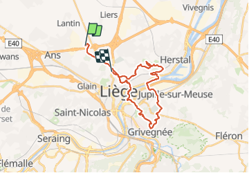
Tour Andere Aktivitäten von 25 km verfügbar auf Wallonien, Lüttich, Lüttich. Diese Tour wird von jojolemarcheur vorgeschlagen.
Beschreibung
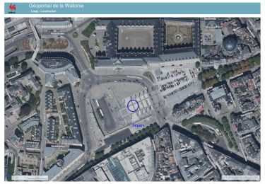
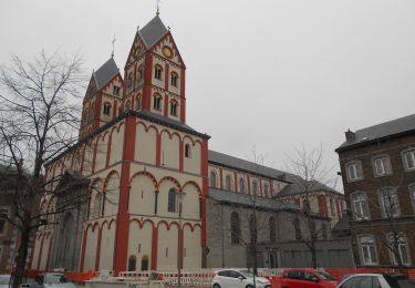
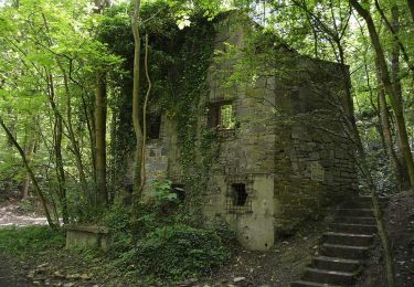
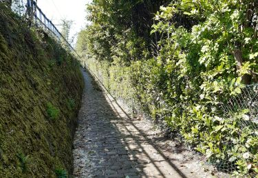
Passage dans les petites ruelles de la ville de Liège, la Citadelle de Liège, le Fort de la Chartreuse, le Crématorium de Robermont, le Halles des Foires de Coronmeuse, le Golf de Bernalmont etc...
Ort
Land:
Belgium
Region :
Wallonien
Abteilung/Provinz :
Lüttich
Kommune :
Lüttich
Standort:
Rocourt
Gehen Sie:(Dec)
Gehen Sie:(UTM)
679484 ; 5616632 (31U) N.
Kommentare
Touren in der Umgebung
![Tour Wandern Lüttich - coteaux de la citadelle liège - Photo](https://media.geolcdn.com/t/375/260/ext.jpg?maxdim=2&url=https%3A%2F%2Fservices.sitytrail.com%2FGeolivesWS%2FDownloadMedia.ashx%3FTrailID%3D114030%26Media%3D89e4d7f6-fadf-43e4-96ab-3cccd7baadb9.jpg)
![Wandern Wandern](https://static1.geolcdn.com/sitytour/trail-icons/101.png)
coteaux de la citadelle liège
Wandern
Medium
(6)
Lüttich,
Wallonien,
Lüttich,
Belgium
![](/images/other/stat-length.png)
14,3 km | 19,8 km-effort
7h 4min
![](https://static1.geolcdn.com/siteimages/upload/files/16400158638029165_repeat_loop_refresh_sync_direction_icon.png)
Ja
![Tour Wandern Lüttich - liege st lambert versant gauche entre ville et nature - Photo](https://media.geolcdn.com/t/375/260/88c52680-ebe2-4244-8d59-4bcee560958c.jpg&format=jpg&maxdim=2)
![Wandern Wandern](https://static1.geolcdn.com/sitytour/trail-icons/101.png)
liege st lambert versant gauche entre ville et nature
Wandern
Medium
(1)
Lüttich,
Wallonien,
Lüttich,
Belgium
![](/images/other/stat-length.png)
10,5 km | 14 km-effort
2h 31min
![](https://static1.geolcdn.com/siteimages/upload/files/16400158638029165_repeat_loop_refresh_sync_direction_icon.png)
Ja
![Tour Wandern Lüttich - 20231029 - TOTEMUS Liège](https://media.geolcdn.com/t/375/260/7b2ecb7c-b811-49e3-b8cb-f4a6ee7afc27.jpeg&format=jpg&maxdim=2)
![Wandern Wandern](https://static1.geolcdn.com/sitytour/trail-icons/101.png)
20231029 - TOTEMUS Liège " De Notger au Palais provincial en passant par la B...
Wandern
Einfach
Lüttich,
Wallonien,
Lüttich,
Belgium
![](/images/other/stat-length.png)
3,9 km | 4,3 km-effort
1h 3min
![](https://static1.geolcdn.com/siteimages/upload/files/16400158638029165_repeat_loop_refresh_sync_direction_icon.png)
Ja
![Tour Wandern Lüttich - tour des terrils liégeois - Photo](https://media.geolcdn.com/t/375/260/ad42a46a-dbdf-4e4e-8410-610288228746.jpg&format=jpg&maxdim=2)
![Wandern Wandern](https://static1.geolcdn.com/sitytour/trail-icons/101.png)
tour des terrils liégeois
Wandern
Medium
(1)
Lüttich,
Wallonien,
Lüttich,
Belgium
![](/images/other/stat-length.png)
9,9 km | 13,3 km-effort
2h 30min
![](https://static1.geolcdn.com/siteimages/upload/files/16400158638029165_repeat_loop_refresh_sync_direction_icon.png)
Ja
![Wandern Wandern](https://static1.geolcdn.com/sitytour/trail-icons/101.png)
20221204 - TOTEMUS Liège - 4.3 Km
Wandern
Einfach
Lüttich,
Wallonien,
Lüttich,
Belgium
![](/images/other/stat-length.png)
4,3 km | 4,6 km-effort
1h 59min
![](https://static1.geolcdn.com/siteimages/upload/files/16400158638029165_repeat_loop_refresh_sync_direction_icon.png)
Nein
![Tour Wandern Lüttich - SityTrail - 2017-07-21 Liege (10Kms) - Photo](https://media.geolcdn.com/t/375/260/ext.jpg?maxdim=2&url=https%3A%2F%2Fstatic1.geolcdn.com%2Fsiteimages%2Fupload%2Ffiles%2F1553511878bg_sport_marche.png)
![Wandern Wandern](https://static1.geolcdn.com/sitytour/trail-icons/101.png)
SityTrail - 2017-07-21 Liege (10Kms)
Wandern
Medium
(1)
Lüttich,
Wallonien,
Lüttich,
Belgium
![](/images/other/stat-length.png)
8,4 km | 11,6 km-effort
2h 30min
![](https://static1.geolcdn.com/siteimages/upload/files/16400158638029165_repeat_loop_refresh_sync_direction_icon.png)
Ja
![Tour Zu Fuß Lüttich - Mon parcours - Photo](https://media.geolcdn.com/t/375/260/f53b9fab-90c2-49c3-8a79-2f5cefdf7f0a.jpg&format=jpg&maxdim=2)
![Zu Fuß Zu Fuß](https://static1.geolcdn.com/sitytour/trail-icons/100.png)
Mon parcours
Zu Fuß
Medium
(1)
Lüttich,
Wallonien,
Lüttich,
Belgium
![](/images/other/stat-length.png)
2,9 km | 3,5 km-effort
Unbekannt
![](https://static1.geolcdn.com/siteimages/upload/files/16400158638029165_repeat_loop_refresh_sync_direction_icon.png)
Nein
![Tour Mountainbike Lüttich - Premier jour - Photo](https://media.geolcdn.com/t/375/260/ext.jpg?maxdim=2&url=https%3A%2F%2Fstatic1.geolcdn.com%2Fsiteimages%2Fupload%2Ffiles%2F1524743154velo.jpg)
![Mountainbike Mountainbike](https://static1.geolcdn.com/sitytour/trail-icons/202.png)
Premier jour
Mountainbike
(1)
Lüttich,
Wallonien,
Lüttich,
Belgium
![](/images/other/stat-length.png)
18,7 km | 0 m-effort
1h 35min
![](https://static1.geolcdn.com/siteimages/upload/files/16400158638029165_repeat_loop_refresh_sync_direction_icon.png)
Nein
![Tour Wandern Lüttich - autour de liege sud-puest : liege - jemeppe Gr579 . grace-hollogne - liege GR412 - Photo](https://media.geolcdn.com/t/375/260/c58f5c99-75b7-4d7a-a440-06e4594f865a.jpg&format=jpg&maxdim=2)
![Wandern Wandern](https://static1.geolcdn.com/sitytour/trail-icons/101.png)
autour de liege sud-puest : liege - jemeppe Gr579 . grace-hollogne - liege GR412
Wandern
Sehr leicht
Lüttich,
Wallonien,
Lüttich,
Belgium
![](/images/other/stat-length.png)
18,4 km | 22 km-effort
4h 17min
![](https://static1.geolcdn.com/siteimages/upload/files/16400158638029165_repeat_loop_refresh_sync_direction_icon.png)
Ja