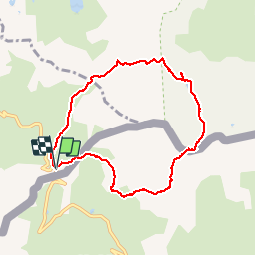
![](/images/other/stat-length.png)
![Tour Wandern Molines-en-Queyras - le tour du Pain de Sucre - Photo](https://media.geolcdn.com/t/1900/400/ext.pjpeg?maxdim=2&url=https%3A%2F%2Fservices.sitytrail.com%2FGeolivesWS%2FDownloadMedia.ashx%3FTrailID%3D820382%26Media%3Dfix__20170830144825.jpg)
le tour du Pain de Sucre
amiral13
Benutzer GUIDE
![Länge](/images/other/stat-length.png)
![Maximale Höhe](https://static1.geolcdn.com/siteimages/upload/files/1508320355ic_sort_altitude_max_24dp.png)
![Positive Höhendifferenz](https://static1.geolcdn.com/siteimages/upload/files/1508320355ic_sort_den_pos_24dp.png)
![Km-Effort](/images/other/stat-length.png)
![Min. Höhe](https://static1.geolcdn.com/siteimages/upload/files/1508320355ic_sort_altitude_min_24dp.png)
![Negative Höhendifferenz](https://static1.geolcdn.com/siteimages/upload/files/1508320355ic_sort_den_neg_24dp.png)
![Boucle](https://static1.geolcdn.com/siteimages/upload/files/16400158638029165_repeat_loop_refresh_sync_direction_icon.png)
![Wandern](https://static1.geolcdn.com/sitytour/trail-icons/101.png)
4h57
Schwierigkeit : Schwierig
![Scannen Sie diesen QR-Code, um die Tour in der SityTrail-Anwendung zu öffnen](https://capi.geolives.com/qq0zvz2zws4bq2lad0pu/sitytour/trails/820382/qr.png?size=200)
Kostenlosegpshiking-Anwendung
Über SityTrail
Tour Wandern von 8,1 km verfügbar auf Provence-Alpes-Côte d'Azur, Hochalpen, Molines-en-Queyras. Diese Tour wird von amiral13 vorgeschlagen.
Beschreibung
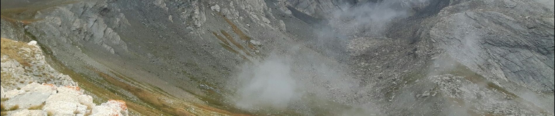
la cotation difficile est due à la partie Italienne de l'itinéraire. La descente du col d'Asti débute par un sentier bien tracé mais pas très stable et débouche sur un long chaos rocheux qu'il faut traverser à vue en suivant les cairn de proche en proche. Une fois le chaos franchi, 2 solutions s'offrent à vous 1- descendre jusqu'à la route et la suivre jusqu'au col Agnel. 2- remonter dans les pentes herbeuses de quelques dizaines de mètres de dénivelée pour ensuite rester à flanc de la pente pour rejoindre la crête d'accès au pain de sucre; il n'existe pas de sente sauf sous la crête finale.
Toute cette partie d'itinéraire en Italie est à proscrire en cas de mauvaise visibilité.
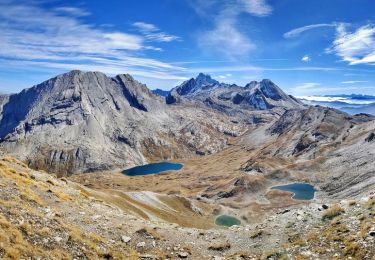
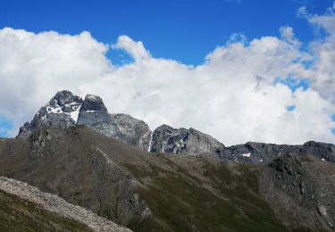
Ort
Kommentare
Touren in der Umgebung
![Tour Wandern Saint-Véran - Lac de la Blanche, lacs blanchet et pic de Caramantran - Photo](https://media.geolcdn.com/t/375/260/ext.jpg?maxdim=2&url=https%3A%2F%2Fservices.sitytrail.com%2FGeolivesWS%2FDownloadMedia.ashx%3FTrailID%3D596077%26Media%3Dfix__20160710142025.jpg)
![Wandern Wandern](https://static1.geolcdn.com/sitytour/trail-icons/101.png)
Wandern
![](/images/other/stat-length.png)
![](https://static1.geolcdn.com/siteimages/upload/files/16400158638029165_repeat_loop_refresh_sync_direction_icon.png)
![Tour Wandern Pontechianale - ITALIE BELLINO CHIANALE . TOUR DU PAIN DU SUCRE . AR. O - Photo](https://media.geolcdn.com/t/375/260/605ee47c-e413-41ea-82a5-10806d48b77c.jpg&format=jpg&maxdim=2)
![Wandern Wandern](https://static1.geolcdn.com/sitytour/trail-icons/101.png)
Wandern
![](/images/other/stat-length.png)
![](https://static1.geolcdn.com/siteimages/upload/files/16400158638029165_repeat_loop_refresh_sync_direction_icon.png)
![Tour Wandern Saint-Véran - Pic de Caramantran - Photo](https://media.geolcdn.com/t/375/260/ext.jpg?maxdim=2&url=https%3A%2F%2Fservices.sitytrail.com%2FGeolivesWS%2FDownloadMedia.ashx%3FTrailID%3D629317%26Media%3D93967439-727d-490c-bf0f-c5937248e7c8.jpg)
![Wandern Wandern](https://static1.geolcdn.com/sitytour/trail-icons/101.png)
Wandern
![](/images/other/stat-length.png)
![](https://static1.geolcdn.com/siteimages/upload/files/16400158638029165_repeat_loop_refresh_sync_direction_icon.png)
![Tour Wandern Molines-en-Queyras - Lacs Foréant, Egorgéou, Baricle et de l'Eychassier - Photo](https://media.geolcdn.com/t/375/260/ext.jpg?maxdim=2&url=https%3A%2F%2Fservices.sitytrail.com%2FGeolivesWS%2FDownloadMedia.ashx%3FTrailID%3D597581%26Media%3Dfix__20160713160454.jpg)
![Wandern Wandern](https://static1.geolcdn.com/sitytour/trail-icons/101.png)
Wandern
![](/images/other/stat-length.png)
![](https://static1.geolcdn.com/siteimages/upload/files/16400158638029165_repeat_loop_refresh_sync_direction_icon.png)
![Tour Wandern Molines-en-Queyras - le pain de sucre - Photo](https://media.geolcdn.com/t/375/260/ext.jpg?maxdim=2&url=https%3A%2F%2Fservices.sitytrail.com%2FGeolivesWS%2FDownloadMedia.ashx%3FTrailID%3D444362%26Media%3Dfix__20150712140232.jpg)
![Wandern Wandern](https://static1.geolcdn.com/sitytour/trail-icons/101.png)
Wandern
![](/images/other/stat-length.png)
![](https://static1.geolcdn.com/siteimages/upload/files/16400158638029165_repeat_loop_refresh_sync_direction_icon.png)
![Tour Wandern Pontechianale - pain de sucre circuit - Photo](https://media.geolcdn.com/t/375/260/765c798f-47ae-4e08-a9cf-50bd35561578.jpg&format=jpg&maxdim=2)
![Wandern Wandern](https://static1.geolcdn.com/sitytour/trail-icons/101.png)
Wandern
![](/images/other/stat-length.png)
![](https://static1.geolcdn.com/siteimages/upload/files/16400158638029165_repeat_loop_refresh_sync_direction_icon.png)
![Tour Wandern Molines-en-Queyras - Pic Foréant et Col d'Asti - Photo](https://media.geolcdn.com/t/375/260/0a0f75bf-b7eb-4c17-be04-8e1330cfc2d9.jpg&format=jpg&maxdim=2)
![Wandern Wandern](https://static1.geolcdn.com/sitytour/trail-icons/101.png)
Wandern
![](/images/other/stat-length.png)
![](https://static1.geolcdn.com/siteimages/upload/files/16400158638029165_repeat_loop_refresh_sync_direction_icon.png)
![Tour Wandern Molines-en-Queyras - 05-Pain-de-sucre-6.5km-525m-aout21 - Photo](https://media.geolcdn.com/t/375/260/7e381716-a2f4-4b1d-8463-85a8f85532fe.jpg&format=jpg&maxdim=2)
![Wandern Wandern](https://static1.geolcdn.com/sitytour/trail-icons/101.png)
Wandern
![](/images/other/stat-length.png)
![](https://static1.geolcdn.com/siteimages/upload/files/16400158638029165_repeat_loop_refresh_sync_direction_icon.png)
![Tour Wandern Molines-en-Queyras - Refuge Agnel-lac Foreant-col Agnel 23 07 2020 - Photo](https://media.geolcdn.com/t/375/260/d42f62fe-5da1-4405-88df-e93345b333da.jpg&format=jpg&maxdim=2)
![Wandern Wandern](https://static1.geolcdn.com/sitytour/trail-icons/101.png)
Wandern
![](/images/other/stat-length.png)
![](https://static1.geolcdn.com/siteimages/upload/files/16400158638029165_repeat_loop_refresh_sync_direction_icon.png)