![](/images/other/stat-length.png)
![Tour Wandern Le Grand-Bornand - roc des tours - Photo](https://media.geolcdn.com/t/1900/400/ext.pjpeg?maxdim=2&url=https%3A%2F%2Fstatic1.geolcdn.com%2Fsiteimages%2Fupload%2Ffiles%2F1553511878bg_sport_marche.png)
roc des tours
macada
Benutzer
![Länge](/images/other/stat-length.png)
![Maximale Höhe](https://static1.geolcdn.com/siteimages/upload/files/1508320355ic_sort_altitude_max_24dp.png)
![Positive Höhendifferenz](https://static1.geolcdn.com/siteimages/upload/files/1508320355ic_sort_den_pos_24dp.png)
![Km-Effort](/images/other/stat-length.png)
![Min. Höhe](https://static1.geolcdn.com/siteimages/upload/files/1508320355ic_sort_altitude_min_24dp.png)
![Negative Höhendifferenz](https://static1.geolcdn.com/siteimages/upload/files/1508320355ic_sort_den_neg_24dp.png)
![Boucle](https://static1.geolcdn.com/siteimages/upload/files/16400158638029165_repeat_loop_refresh_sync_direction_icon.png)
![Wandern](https://static1.geolcdn.com/sitytour/trail-icons/101.png)
3h13
Schwierigkeit : Schwierig
![Scannen Sie diesen QR-Code, um die Tour in der SityTrail-Anwendung zu öffnen](https://capi.geolives.com/qq0zvz2zws4bq2lad0pu/sitytour/trails/808414/qr.png?size=200)
Kostenlosegpshiking-Anwendung
Über SityTrail
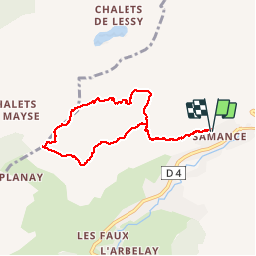
Tour Wandern von 7,1 km verfügbar auf Auvergne-Rhone-Alpen, Hochsavoyen, Le Grand-Bornand. Diese Tour wird von macada vorgeschlagen.
Beschreibung
Cette rando d'été n'a qu'une difficulté. Après les chalets de La Gaudinière "d'en haut", le sentier devient étroit et n'est plus marqué que par quelques rares points bleus délavés: Suivre ce sentier qui monte assez régulièrement à travers l'alpage jusqu'à l'altitude 1720m.Là se trouve un rocher avec de grandes marques bleues:"Roc des tours".C'est là que l'on change de direction et que l'on attaque la montée raide de la falaise. On est souvent forcé de s'aider des mains.Les 500 derniers mètres de la montée sont très beaux, avec vue plongeante sur le col de la Culaz.Le retour se fait sans difficultés.
Ort
Kommentare
Touren in der Umgebung
![Tour Wandern Glières-Val-de-Borne - BARGY: ROCHERS DE LESCHAUX AU DEPART DE CENISE - Photo](https://media.geolcdn.com/t/375/260/5ac05f8e-3735-47a8-a18c-c0c850908ba7.jpg&format=jpg&maxdim=2)
![Wandern Wandern](https://static1.geolcdn.com/sitytour/trail-icons/101.png)
Wandern
![](/images/other/stat-length.png)
![](https://static1.geolcdn.com/siteimages/upload/files/16400158638029165_repeat_loop_refresh_sync_direction_icon.png)
![Tour Wandern Le Grand-Bornand - Lac de Lessy depuis le Chinaillon - Photo](https://media.geolcdn.com/t/375/260/ext.jpg?maxdim=2&url=https%3A%2F%2Fservices.sitytrail.com%2FGeolivesWS%2FDownloadMedia.ashx%3FTrailID%3D224812%26Media%3Dfix__20130925155702.jpg)
![Wandern Wandern](https://static1.geolcdn.com/sitytour/trail-icons/101.png)
Wandern
![](/images/other/stat-length.png)
![](https://static1.geolcdn.com/siteimages/upload/files/16400158638029165_repeat_loop_refresh_sync_direction_icon.png)
![Tour Wandern Le Reposoir - Le Petit Bargy 2098 m, depuis Malatrait - Photo](https://media.geolcdn.com/t/375/260/ext.jpg?maxdim=2&url=https%3A%2F%2Fservices.sitytrail.com%2FGeolivesWS%2FDownloadMedia.ashx%3FTrailID%3D215073%26Media%3D15647_1.jpg)
![Wandern Wandern](https://static1.geolcdn.com/sitytour/trail-icons/101.png)
Wandern
![](/images/other/stat-length.png)
![](https://static1.geolcdn.com/siteimages/upload/files/16400158638029165_repeat_loop_refresh_sync_direction_icon.png)
![Tour Skiwanderen Le Grand-Bornand - Col de Balafrasse et tout de la pointe Est du midi - Photo](https://media.geolcdn.com/t/375/260/43833717-d102-4f65-80da-59cdd532a1e7.jpg&format=jpg&maxdim=2)
![Skiwanderen Skiwanderen](https://static1.geolcdn.com/sitytour/trail-icons/503.png)
Skiwanderen
![](/images/other/stat-length.png)
![](https://static1.geolcdn.com/siteimages/upload/files/16400158638029165_repeat_loop_refresh_sync_direction_icon.png)
![Tour Skiwanderen Le Grand-Bornand - PT 2595au dessus du col des Verts - Photo](https://media.geolcdn.com/t/375/260/adf344e5-4ea3-43cf-966b-fc21b915cec5.jpg&format=jpg&maxdim=2)
![Skiwanderen Skiwanderen](https://static1.geolcdn.com/sitytour/trail-icons/503.png)
Skiwanderen
![](/images/other/stat-length.png)
![](https://static1.geolcdn.com/siteimages/upload/files/16400158638029165_repeat_loop_refresh_sync_direction_icon.png)
![Tour Skiwanderen Glières-Val-de-Borne - Tour du Jallouvre par le lac de Lessy - Photo](https://media.geolcdn.com/t/375/260/1d705345-d276-40a8-b673-92ff954efff5.jpg&format=jpg&maxdim=2)
![Skiwanderen Skiwanderen](https://static1.geolcdn.com/sitytour/trail-icons/503.png)
Skiwanderen
![](/images/other/stat-length.png)
![](https://static1.geolcdn.com/siteimages/upload/files/16400158638029165_repeat_loop_refresh_sync_direction_icon.png)
![Tour Skiwanderen Glières-Val-de-Borne - col du rasoir combe NW ET Sud - Photo](https://media.geolcdn.com/t/375/260/c51ae7d8-65f2-4ba4-b4a6-8cbff7bf96a0.jpg&format=jpg&maxdim=2)
![Skiwanderen Skiwanderen](https://static1.geolcdn.com/sitytour/trail-icons/503.png)
Skiwanderen
![](/images/other/stat-length.png)
![](https://static1.geolcdn.com/siteimages/upload/files/16400158638029165_repeat_loop_refresh_sync_direction_icon.png)
![Mountainbike Mountainbike](https://static1.geolcdn.com/sitytour/trail-icons/202.png)
Mountainbike
![](/images/other/stat-length.png)
![](https://static1.geolcdn.com/siteimages/upload/files/16400158638029165_repeat_loop_refresh_sync_direction_icon.png)
![Mountainbike Mountainbike](https://static1.geolcdn.com/sitytour/trail-icons/202.png)
Mountainbike
![](/images/other/stat-length.png)
![](https://static1.geolcdn.com/siteimages/upload/files/16400158638029165_repeat_loop_refresh_sync_direction_icon.png)