![](/images/other/stat-length.png)
![Tour Wandern Poule-les-Écharmeaux - Les Echarmeaux (18km D. 574) m - Photo](https://media.geolcdn.com/t/1900/400/ext.pjpeg?maxdim=2&url=https%3A%2F%2Fstatic1.geolcdn.com%2Fsiteimages%2Fupload%2Ffiles%2F1553511878bg_sport_marche.png)
Les Echarmeaux (18km D. 574) m
Thomasdanielle
Benutzer
![Länge](/images/other/stat-length.png)
Länge
18,1 km
![Maximale Höhe](https://static1.geolcdn.com/siteimages/upload/files/1508320355ic_sort_altitude_max_24dp.png)
Maximale Höhe
883 m
![Positive Höhendifferenz](https://static1.geolcdn.com/siteimages/upload/files/1508320355ic_sort_den_pos_24dp.png)
Positive Höhendifferenz
589 m
![Km-Effort](/images/other/stat-length.png)
Km-Effort
26 km
![Min. Höhe](https://static1.geolcdn.com/siteimages/upload/files/1508320355ic_sort_altitude_min_24dp.png)
Min. Höhe
493 m
![Negative Höhendifferenz](https://static1.geolcdn.com/siteimages/upload/files/1508320355ic_sort_den_neg_24dp.png)
Negative Höhendifferenz
590 m
![Boucle](https://static1.geolcdn.com/siteimages/upload/files/16400158638029165_repeat_loop_refresh_sync_direction_icon.png)
Boucle
Ja
Erstellungsdatum :
2017-08-07 00:00:00.0
Letzte Änderung :
2017-08-07 00:00:00.0
![Wandern](https://static1.geolcdn.com/sitytour/trail-icons/101.png)
5h25
Schwierigkeit : Medium
![Scannen Sie diesen QR-Code, um die Tour in der SityTrail-Anwendung zu öffnen](https://capi.geolives.com/qq0zvz2zws4bq2lad0pu/sitytour/trails/804696/qr.png?size=200)
Kostenlosegpshiking-Anwendung
Über SityTrail
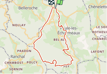
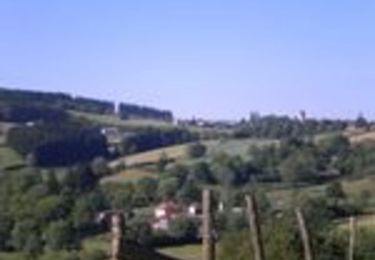
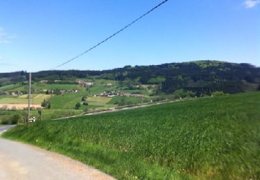
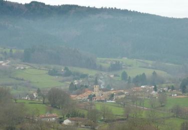
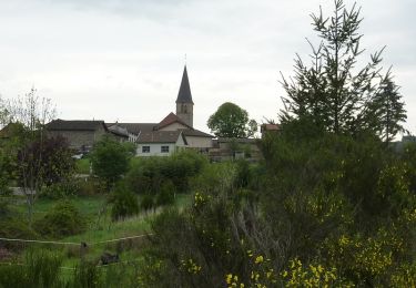
Tour Wandern von 18,1 km verfügbar auf Auvergne-Rhone-Alpen, Rhône, Poule-les-Écharmeaux. Diese Tour wird von Thomasdanielle vorgeschlagen.
Beschreibung
Départ parking des Echarmeaux (en bas) - direction l'Eglise, La fabrique, La Chavanne, Pieds de Pey,, Bois de Pey, Croix de la moule, la croix de Fer, col des Aillets, le Mont Joly
Ort
Land:
France
Region :
Auvergne-Rhone-Alpen
Abteilung/Provinz :
Rhône
Kommune :
Poule-les-Écharmeaux
Standort:
Unknown
Gehen Sie:(Dec)
Gehen Sie:(UTM)
611327 ; 5113617 (31T) N.
Kommentare
Touren in der Umgebung
![Tour Wandern Saint-Germain-la-Montagne - Circuit du Tourniquet - Saint Germain la Montagne - Photo](https://media.geolcdn.com/t/375/260/ext.jpg?maxdim=2&url=https%3A%2F%2Fservices.sitytrail.com%2FGeolivesWS%2FDownloadMedia.ashx%3FTrailID%3D107382%26Media%3D12284_6.jpg)
![Wandern Wandern](https://static1.geolcdn.com/sitytour/trail-icons/101.png)
Circuit du Tourniquet - Saint Germain la Montagne
Wandern
Schwierig
(1)
Saint-Germain-la-Montagne,
Auvergne-Rhone-Alpen,
Loire,
France
![](/images/other/stat-length.png)
15 km | 22 km-effort
4h 0min
![](https://static1.geolcdn.com/siteimages/upload/files/16400158638029165_repeat_loop_refresh_sync_direction_icon.png)
Ja
![Tour Wandern Ranchal - Ranchal village vert - Photo](https://media.geolcdn.com/t/375/260/ext.jpg?maxdim=2&url=https%3A%2F%2Fservices.sitytrail.com%2FGeolivesWS%2FDownloadMedia.ashx%3FTrailID%3D105056%26Media%3D8641_6.jpg)
![Wandern Wandern](https://static1.geolcdn.com/sitytour/trail-icons/101.png)
Ranchal village vert
Wandern
Medium
(1)
Ranchal,
Auvergne-Rhone-Alpen,
Rhône,
France
![](/images/other/stat-length.png)
10,2 km | 14,2 km-effort
2h 0min
![](https://static1.geolcdn.com/siteimages/upload/files/16400158638029165_repeat_loop_refresh_sync_direction_icon.png)
Ja
![Tour Zu Fuß Propières - Circuit de Propières n°3 - 15 km - Noir - Photo](https://media.geolcdn.com/t/375/260/8e2640e6-7b75-4b6e-a5e9-fe114f5074bb.jpeg&format=jpg&maxdim=2)
![Zu Fuß Zu Fuß](https://static1.geolcdn.com/sitytour/trail-icons/100.png)
Circuit de Propières n°3 - 15 km - Noir
Zu Fuß
Medium
Propières,
Auvergne-Rhone-Alpen,
Rhône,
France
![](/images/other/stat-length.png)
14,3 km | 21 km-effort
4h 46min
![](https://static1.geolcdn.com/siteimages/upload/files/16400158638029165_repeat_loop_refresh_sync_direction_icon.png)
Ja
![Tour Zu Fuß Propières - Circuit du Mont Saint-Rigaud 12 km - Photo](https://media.geolcdn.com/t/375/260/8fe17dfa-2ab9-4de6-a590-f911d28759c5.jpeg&format=jpg&maxdim=2)
![Zu Fuß Zu Fuß](https://static1.geolcdn.com/sitytour/trail-icons/100.png)
Circuit du Mont Saint-Rigaud 12 km
Zu Fuß
Einfach
Propières,
Auvergne-Rhone-Alpen,
Rhône,
France
![](/images/other/stat-length.png)
11,8 km | 18,3 km-effort
4h 9min
![](https://static1.geolcdn.com/siteimages/upload/files/16400158638029165_repeat_loop_refresh_sync_direction_icon.png)
Ja
![Tour Wandern Propières - Circuit de Propières - Photo](https://media.geolcdn.com/t/375/260/ext.jpg?maxdim=2&url=https%3A%2F%2Fservices.sitytrail.com%2FGeolivesWS%2FDownloadMedia.ashx%3FTrailID%3D172258%26Media%3D13567_3.jpg)
![Wandern Wandern](https://static1.geolcdn.com/sitytour/trail-icons/101.png)
Circuit de Propières
Wandern
Schwierig
Propières,
Auvergne-Rhone-Alpen,
Rhône,
France
![](/images/other/stat-length.png)
14,3 km | 21 km-effort
5h 0min
![](https://static1.geolcdn.com/siteimages/upload/files/16400158638029165_repeat_loop_refresh_sync_direction_icon.png)
Ja
![Tour Mountainbike Belleroche - Marche de Belleroche - Photo](https://media.geolcdn.com/t/375/260/ext.jpg?maxdim=2&url=https%3A%2F%2Fservices.sitytrail.com%2FGeolivesWS%2FDownloadMedia.ashx%3FTrailID%3D127260%26Media%3D20120513142447.jpg)
![Mountainbike Mountainbike](https://static1.geolcdn.com/sitytour/trail-icons/202.png)
Marche de Belleroche
Mountainbike
Schwierig
Belleroche,
Auvergne-Rhone-Alpen,
Loire,
France
![](/images/other/stat-length.png)
33 km | 48 km-effort
2h 59min
![](https://static1.geolcdn.com/siteimages/upload/files/16400158638029165_repeat_loop_refresh_sync_direction_icon.png)
Ja
![Tour Wandern Belleroche - Belleroche - Circuit du Mont Joly - Photo](https://media.geolcdn.com/t/375/260/ext.jpg?maxdim=2&url=https%3A%2F%2Fservices.sitytrail.com%2FGeolivesWS%2FDownloadMedia.ashx%3FTrailID%3D105996%26Media%3D10116_6.jpg)
![Wandern Wandern](https://static1.geolcdn.com/sitytour/trail-icons/101.png)
Belleroche - Circuit du Mont Joly
Wandern
Medium
(1)
Belleroche,
Auvergne-Rhone-Alpen,
Loire,
France
![](/images/other/stat-length.png)
8,1 km | 11,9 km-effort
2h 30min
![](https://static1.geolcdn.com/siteimages/upload/files/16400158638029165_repeat_loop_refresh_sync_direction_icon.png)
Ja
![Tour Mountainbike Belleroche - VTT à Belleroche - Rando 2010 - Photo](https://media.geolcdn.com/t/375/260/ext.jpg?maxdim=2&url=https%3A%2F%2Fservices.sitytrail.com%2FGeolivesWS%2FDownloadMedia.ashx%3FTrailID%3D104977%26Media%3D8534_6.jpg)
![Mountainbike Mountainbike](https://static1.geolcdn.com/sitytour/trail-icons/202.png)
VTT à Belleroche - Rando 2010
Mountainbike
Sehr schwierig
Belleroche,
Auvergne-Rhone-Alpen,
Loire,
France
![](/images/other/stat-length.png)
43 km | 63 km-effort
4h 15min
![](https://static1.geolcdn.com/siteimages/upload/files/16400158638029165_repeat_loop_refresh_sync_direction_icon.png)
Ja
![Tour Zu Fuß Propières - sejour-rcy-journee-4-les-cretes-du-haut-beaujolais-dkMvOIHhXD - Photo](https://media.geolcdn.com/t/375/260/ext.jpg?maxdim=2&url=https%3A%2F%2Fstatic1.geolcdn.com%2Fsiteimages%2Fupload%2Ffiles%2F1545311037marcheuse_200dpi.jpg)
![Zu Fuß Zu Fuß](https://static1.geolcdn.com/sitytour/trail-icons/100.png)
sejour-rcy-journee-4-les-cretes-du-haut-beaujolais-dkMvOIHhXD
Zu Fuß
Schwierig
Propières,
Auvergne-Rhone-Alpen,
Rhône,
France
![](/images/other/stat-length.png)
28 km | 39 km-effort
8h 55min
![](https://static1.geolcdn.com/siteimages/upload/files/16400158638029165_repeat_loop_refresh_sync_direction_icon.png)
Nein