


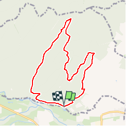

13 km | 18,5 km-effort


Benutzer


Kostenlosegpshiking-Anwendung
 SityTrail
IGN / Geografische Institute
SityTrail World
Die Welt öffnet sich für Sie
Tour Wandern von 8,3 km verfügbar auf Großer Osten, Unterelsass, Scherweiler. Diese Tour wird von Luster vorgeschlagen.
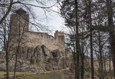
Départ Huehnelmuehl, circuit autour du château de l'Ortenbourg. Altitude max. 474 m et mini.205 m. Tour de 3 hrsen moyenne.

Wandern

Wandern

Wandern

Wandern

Wandern

Mountainbike
Wandern
Wandern
Elektrofahrrad