![](/images/other/stat-length.png)
![Tour Wandern Salérans - Crête de Chanteduc - Photo](https://media.geolcdn.com/t/1900/400/ext.pjpeg?maxdim=2&url=https%3A%2F%2Fstatic1.geolcdn.com%2Fsiteimages%2Fupload%2Ffiles%2F1553511878bg_sport_marche.png)
Crête de Chanteduc
rigol05
Benutzer
![Länge](/images/other/stat-length.png)
![Maximale Höhe](https://static1.geolcdn.com/siteimages/upload/files/1508320355ic_sort_altitude_max_24dp.png)
![Positive Höhendifferenz](https://static1.geolcdn.com/siteimages/upload/files/1508320355ic_sort_den_pos_24dp.png)
![Km-Effort](/images/other/stat-length.png)
![Min. Höhe](https://static1.geolcdn.com/siteimages/upload/files/1508320355ic_sort_altitude_min_24dp.png)
![Negative Höhendifferenz](https://static1.geolcdn.com/siteimages/upload/files/1508320355ic_sort_den_neg_24dp.png)
![Boucle](https://static1.geolcdn.com/siteimages/upload/files/16400158638029165_repeat_loop_refresh_sync_direction_icon.png)
![Wandern](https://static1.geolcdn.com/sitytour/trail-icons/101.png)
4h50
Schwierigkeit : Schwierig
![Scannen Sie diesen QR-Code, um die Tour in der SityTrail-Anwendung zu öffnen](https://capi.geolives.com/qq0zvz2zws4bq2lad0pu/sitytour/trails/795550/qr.png?size=200)
Kostenlosegpshiking-Anwendung
Über SityTrail
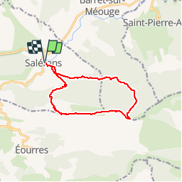
Tour Wandern von 12,4 km verfügbar auf Provence-Alpes-Côte d'Azur, Hochalpen, Salérans. Diese Tour wird von rigol05 vorgeschlagen.
Beschreibung
Sortie du 24/07/2017
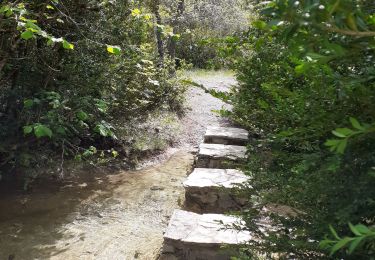
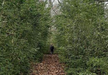
L'itinéraire pour atteindre la crête ne passe certainement plus comme indiqué sur la carte. Le balisage est très ancien, après le passage du Rocher de l'Aigle, le sentier se perd dans la végétation.Guidage à vue en traversant des taillis de buis pour rejoindre le Chaume d'Eourres, puis le poteau indicateur de la crête de Chanteduc; Le reste du parcours ne pose aucun problème.
Ort
Kommentare
Touren in der Umgebung
![Tour Wandern Barret-sur-Méouge - 05 gorges meouge 03.08.23. semi aquatique un - Photo](https://media.geolcdn.com/t/375/260/f11f4fcf-0a2e-4abf-97b4-d5928fbacb3f.jpg&format=jpg&maxdim=2)
![Wandern Wandern](https://static1.geolcdn.com/sitytour/trail-icons/101.png)
Wandern
![](/images/other/stat-length.png)
![](https://static1.geolcdn.com/siteimages/upload/files/16400158638029165_repeat_loop_refresh_sync_direction_icon.png)
![Tour Wandern Éourres - EOURRES. Les Damias , col S Pierre , col de Branche , crête de Chanteduc , o l m s - Photo](https://media.geolcdn.com/t/375/260/3b7359cb-4882-4b12-affe-3c4a3595001b.jpg&format=jpg&maxdim=2)
![Wandern Wandern](https://static1.geolcdn.com/sitytour/trail-icons/101.png)
Wandern
![](/images/other/stat-length.png)
![](https://static1.geolcdn.com/siteimages/upload/files/16400158638029165_repeat_loop_refresh_sync_direction_icon.png)
![Tour Wandern Éourres - mare et pied du mulet - Photo](https://media.geolcdn.com/t/375/260/ext.jpg?maxdim=2&url=https%3A%2F%2Fstatic1.geolcdn.com%2Fsiteimages%2Fupload%2Ffiles%2F1553511878bg_sport_marche.png)
![Wandern Wandern](https://static1.geolcdn.com/sitytour/trail-icons/101.png)
Wandern
![](/images/other/stat-length.png)
![](https://static1.geolcdn.com/siteimages/upload/files/16400158638029165_repeat_loop_refresh_sync_direction_icon.png)
![Tour Wandern Saint-Pierre-Avez - 05 meouges pic st Cyr zel - Photo](https://media.geolcdn.com/t/375/260/7d9058f3-f841-4fdc-904d-29c0d1f25052.jpg&format=jpg&maxdim=2)
![Wandern Wandern](https://static1.geolcdn.com/sitytour/trail-icons/101.png)
Wandern
![](/images/other/stat-length.png)
![](https://static1.geolcdn.com/siteimages/upload/files/16400158638029165_repeat_loop_refresh_sync_direction_icon.png)
![Tour Wandern Barret-sur-Méouge - Gorges de la meouge - Photo](https://media.geolcdn.com/t/375/260/a323248a-60d4-48ad-813e-6f1d82312011.jpg&format=jpg&maxdim=2)
![Wandern Wandern](https://static1.geolcdn.com/sitytour/trail-icons/101.png)
Wandern
![](/images/other/stat-length.png)
![](https://static1.geolcdn.com/siteimages/upload/files/16400158638029165_repeat_loop_refresh_sync_direction_icon.png)
![Tour Wandern Barret-sur-Méouge - St-Pierre-Avez/Pomet/St-Pierre-Avez - Photo](https://media.geolcdn.com/t/375/260/6c9379e6-8a08-457e-bdc2-551f8e709154.jpg&format=jpg&maxdim=2)
![Wandern Wandern](https://static1.geolcdn.com/sitytour/trail-icons/101.png)
Wandern
![](/images/other/stat-length.png)
![](https://static1.geolcdn.com/siteimages/upload/files/16400158638029165_repeat_loop_refresh_sync_direction_icon.png)
![Tour Wandern Saint-Pierre-Avez - SAINT PIERRE AVEZ 05 . les Avens , col S Pierre o m - Photo](https://media.geolcdn.com/t/375/260/8ef14ed9-d302-48dd-bb78-66deaf28c9ea.jpg&format=jpg&maxdim=2)
![Wandern Wandern](https://static1.geolcdn.com/sitytour/trail-icons/101.png)
Wandern
![](/images/other/stat-length.png)
![](https://static1.geolcdn.com/siteimages/upload/files/16400158638029165_repeat_loop_refresh_sync_direction_icon.png)
![Tour Wandern Sainte-Colombe - SAINTE COLOMBE . 05 . Pas de Sainte Colombe o m s - Photo](https://media.geolcdn.com/t/375/260/81962515-6c25-41a2-9c57-59c34af424da.jpg&format=jpg&maxdim=2)
![Wandern Wandern](https://static1.geolcdn.com/sitytour/trail-icons/101.png)
Wandern
![](/images/other/stat-length.png)
![](https://static1.geolcdn.com/siteimages/upload/files/16400158638029165_repeat_loop_refresh_sync_direction_icon.png)
![Tour Wandern Éourres - EOURRES , les Diamas , certes de Chanteduc , col de Branche , col de Garasse , col St Pierre o - Photo](https://media.geolcdn.com/t/375/260/a9298ccf-88ce-4364-a6d7-8f59f2d7711b.jpg&format=jpg&maxdim=2)
![Wandern Wandern](https://static1.geolcdn.com/sitytour/trail-icons/101.png)
Wandern
![](/images/other/stat-length.png)
![](https://static1.geolcdn.com/siteimages/upload/files/16400158638029165_repeat_loop_refresh_sync_direction_icon.png)