![](/images/other/stat-length.png)
Tancarville: Les cigognes, les cygnes et la vie sauvage du marais
MarcherEnsemble
Benutzer
![Länge](/images/other/stat-length.png)
Länge
8,1 km
![Maximale Höhe](https://static1.geolcdn.com/siteimages/upload/files/1508320355ic_sort_altitude_max_24dp.png)
Maximale Höhe
8 m
![Positive Höhendifferenz](https://static1.geolcdn.com/siteimages/upload/files/1508320355ic_sort_den_pos_24dp.png)
Positive Höhendifferenz
26 m
![Km-Effort](/images/other/stat-length.png)
Km-Effort
8,5 km
![Min. Höhe](https://static1.geolcdn.com/siteimages/upload/files/1508320355ic_sort_altitude_min_24dp.png)
Min. Höhe
0 m
![Negative Höhendifferenz](https://static1.geolcdn.com/siteimages/upload/files/1508320355ic_sort_den_neg_24dp.png)
Negative Höhendifferenz
28 m
![Boucle](https://static1.geolcdn.com/siteimages/upload/files/16400158638029165_repeat_loop_refresh_sync_direction_icon.png)
Boucle
Nein
Erstellungsdatum :
2017-12-26 00:00:00.0
Letzte Änderung :
2020-08-25 14:23:25.072
![Wandern](https://static1.geolcdn.com/sitytour/trail-icons/101.png)
3h00
Schwierigkeit : Sehr leicht
![Scannen Sie diesen QR-Code, um die Tour in der SityTrail-Anwendung zu öffnen](https://capi.geolives.com/qq0zvz2zws4bq2lad0pu/sitytour/trails/791460/qr.png?size=200)
Kostenlosegpshiking-Anwendung
Über SityTrail
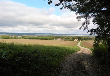
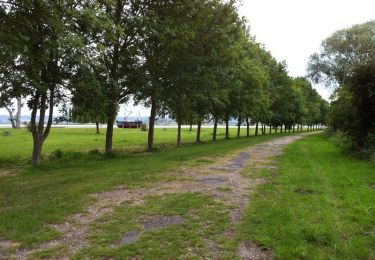
Tour Wandern von 8,1 km verfügbar auf Normandie, Seine-Maritime, Saint-Vigor-d'Ymonville. Diese Tour wird von MarcherEnsemble vorgeschlagen.
Beschreibung
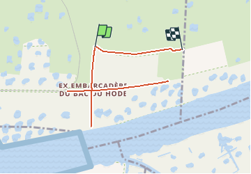
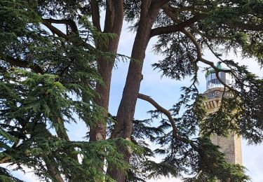
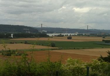
Passer rive gauche par le pont du Hode.
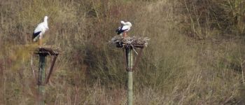
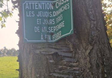
Les cigognes sont dans un espace protégé clos.
Prévoir des jumelles et un téléobjectif, il n'est pas possible de s'approcher très près.
Ort
Land:
France
Region :
Normandie
Abteilung/Provinz :
Seine-Maritime
Kommune :
Saint-Vigor-d'Ymonville
Standort:
Unknown
Gehen Sie:(Dec)
Gehen Sie:(UTM)
309066 ; 5481627 (31U) N.
Kommentare
Touren in der Umgebung
![Tour Wandern Saint-Vigor-d'Ymonville - Saint Vigor d'Ymonville - Photo](https://media.geolcdn.com/t/375/260/021f3857-a5d5-44c4-8b19-1adf31301359.jpg&format=jpg&maxdim=2)
![Wandern Wandern](https://static1.geolcdn.com/sitytour/trail-icons/101.png)
Saint Vigor d'Ymonville
Wandern
Medium
(2)
Saint-Vigor-d'Ymonville,
Normandie,
Seine-Maritime,
France
![](/images/other/stat-length.png)
9,6 km | 10,4 km-effort
2h 34min
![](https://static1.geolcdn.com/siteimages/upload/files/16400158638029165_repeat_loop_refresh_sync_direction_icon.png)
Ja
![Tour Wandern Fatouville-Grestain - HONFLEUR 07 - Phare de Fatouville (Normandie) - Photo](https://media.geolcdn.com/t/375/260/a9f06c6b-2f5e-41a0-a622-52214993db1a.jpg&format=jpg&maxdim=2)
![Wandern Wandern](https://static1.geolcdn.com/sitytour/trail-icons/101.png)
HONFLEUR 07 - Phare de Fatouville (Normandie)
Wandern
Medium
Fatouville-Grestain,
Normandie,
Eure,
France
![](/images/other/stat-length.png)
14,7 km | 18,3 km-effort
3h 39min
![](https://static1.geolcdn.com/siteimages/upload/files/16400158638029165_repeat_loop_refresh_sync_direction_icon.png)
Ja
![Tour Wandern Saint-Samson-de-la-Roque - La Roque - Photo](https://media.geolcdn.com/t/375/260/ext.jpg?maxdim=2&url=https%3A%2F%2Fservices.sitytrail.com%2FGeolivesWS%2FDownloadMedia.ashx%3FTrailID%3D143552%26Media%3D20120804143937.jpg)
![Wandern Wandern](https://static1.geolcdn.com/sitytour/trail-icons/101.png)
La Roque
Wandern
Sehr leicht
Saint-Samson-de-la-Roque,
Normandie,
Eure,
France
![](/images/other/stat-length.png)
14,9 km | 17,7 km-effort
3h 25min
![](https://static1.geolcdn.com/siteimages/upload/files/16400158638029165_repeat_loop_refresh_sync_direction_icon.png)
Nein
![Tour Wandern Sandouville - Sandouville 2023 10 07 - Photo](https://media.geolcdn.com/t/375/260/6695dad7-11b3-4c12-ae95-f4b2d03addac.jpg&format=jpg&maxdim=2)
![Wandern Wandern](https://static1.geolcdn.com/sitytour/trail-icons/101.png)
Sandouville 2023 10 07
Wandern
Sehr schwierig
Sandouville,
Normandie,
Seine-Maritime,
France
![](/images/other/stat-length.png)
21 km | 26 km-effort
5h 49min
![](https://static1.geolcdn.com/siteimages/upload/files/16400158638029165_repeat_loop_refresh_sync_direction_icon.png)
Ja
![Tour Wandern La Cerlangue - St Jean d'Abbetot - Photo](https://media.geolcdn.com/t/375/260/31650e47-20be-49a3-ad90-2dea24357470.jpg&format=jpg&maxdim=2)
![Wandern Wandern](https://static1.geolcdn.com/sitytour/trail-icons/101.png)
St Jean d'Abbetot
Wandern
Einfach
La Cerlangue,
Normandie,
Seine-Maritime,
France
![](/images/other/stat-length.png)
6,4 km | 6,8 km-effort
1h 46min
![](https://static1.geolcdn.com/siteimages/upload/files/16400158638029165_repeat_loop_refresh_sync_direction_icon.png)
Ja
![Zu Fuß Zu Fuß](https://static1.geolcdn.com/sitytour/trail-icons/100.png)
berville sur mer
Zu Fuß
Sehr leicht
Berville-sur-Mer,
Normandie,
Eure,
France
![](/images/other/stat-length.png)
5,5 km | 6,7 km-effort
Unbekannt
![](https://static1.geolcdn.com/siteimages/upload/files/16400158638029165_repeat_loop_refresh_sync_direction_icon.png)
Ja
![Tour Wandern Conteville - De Conteville aux bords de Seine - Photo](https://media.geolcdn.com/t/375/260/ext.jpg?maxdim=2&url=https%3A%2F%2Fservices.sitytrail.com%2FGeolivesWS%2FDownloadMedia.ashx%3FTrailID%3D129781%26Media%3D13325_1.jpg)
![Wandern Wandern](https://static1.geolcdn.com/sitytour/trail-icons/101.png)
De Conteville aux bords de Seine
Wandern
Medium
Conteville,
Normandie,
Eure,
France
![](/images/other/stat-length.png)
20 km | 24 km-effort
3h 54min
![](https://static1.geolcdn.com/siteimages/upload/files/16400158638029165_repeat_loop_refresh_sync_direction_icon.png)
Ja
![Tour Wandern Berville-sur-Mer - Wikiloc - GR®223 Tour du Cotentin (2021) - Photo](https://media.geolcdn.com/t/375/260/ext.jpg?maxdim=2&url=https%3A%2F%2Fstatic1.geolcdn.com%2Fsiteimages%2Fupload%2Ffiles%2F1553511878bg_sport_marche.png)
![Wandern Wandern](https://static1.geolcdn.com/sitytour/trail-icons/101.png)
Wikiloc - GR®223 Tour du Cotentin (2021)
Wandern
Sehr schwierig
Berville-sur-Mer,
Normandie,
Eure,
France
![](/images/other/stat-length.png)
650 km | 737 km-effort
167h 26min
![](https://static1.geolcdn.com/siteimages/upload/files/16400158638029165_repeat_loop_refresh_sync_direction_icon.png)
Nein
![Tour Wandern Berville-sur-Mer - BERVILLE SUR MER - Photo](https://media.geolcdn.com/t/375/260/ext.jpg?maxdim=2&url=https%3A%2F%2Fstatic1.geolcdn.com%2Fsiteimages%2Fupload%2Ffiles%2F1553511878bg_sport_marche.png)
![Wandern Wandern](https://static1.geolcdn.com/sitytour/trail-icons/101.png)
BERVILLE SUR MER
Wandern
Schwierig
Berville-sur-Mer,
Normandie,
Eure,
France
![](/images/other/stat-length.png)
11,1 km | 12,9 km-effort
2h 55min
![](https://static1.geolcdn.com/siteimages/upload/files/16400158638029165_repeat_loop_refresh_sync_direction_icon.png)
Ja