![](/images/other/stat-length.png)
![Tour Wandern Comps - Comps et col de la Pousterle - Photo](https://media.geolcdn.com/t/1900/400/ext.pjpeg?maxdim=2&url=https%3A%2F%2Fservices.sitytrail.com%2FGeolivesWS%2FDownloadMedia.ashx%3FTrailID%3D782781%26Media%3Dfix__20170702181413.jpg)
Comps et col de la Pousterle
rcu3824
Benutzer
![Länge](/images/other/stat-length.png)
Länge
9,8 km
![Maximale Höhe](https://static1.geolcdn.com/siteimages/upload/files/1508320355ic_sort_altitude_max_24dp.png)
Maximale Höhe
927 m
![Positive Höhendifferenz](https://static1.geolcdn.com/siteimages/upload/files/1508320355ic_sort_den_pos_24dp.png)
Positive Höhendifferenz
519 m
![Km-Effort](/images/other/stat-length.png)
Km-Effort
16,8 km
![Min. Höhe](https://static1.geolcdn.com/siteimages/upload/files/1508320355ic_sort_altitude_min_24dp.png)
Min. Höhe
474 m
![Negative Höhendifferenz](https://static1.geolcdn.com/siteimages/upload/files/1508320355ic_sort_den_neg_24dp.png)
Negative Höhendifferenz
527 m
![Boucle](https://static1.geolcdn.com/siteimages/upload/files/16400158638029165_repeat_loop_refresh_sync_direction_icon.png)
Boucle
Ja
Erstellungsdatum :
2017-07-04 00:00:00.0
Letzte Änderung :
2017-07-04 00:00:00.0
![Wandern](https://static1.geolcdn.com/sitytour/trail-icons/101.png)
3h25
Schwierigkeit : Einfach
![Scannen Sie diesen QR-Code, um die Tour in der SityTrail-Anwendung zu öffnen](https://capi.geolives.com/qq0zvz2zws4bq2lad0pu/sitytour/trails/782781/qr.png?size=200)
Kostenlosegpshiking-Anwendung
Über SityTrail
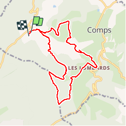
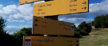
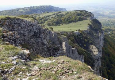
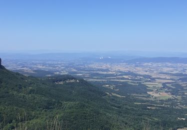
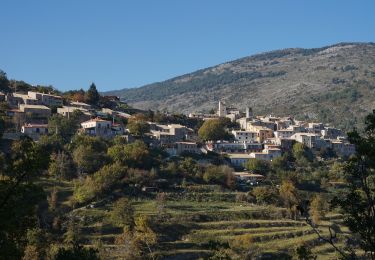
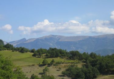
Tour Wandern von 9,8 km verfügbar auf Auvergne-Rhone-Alpen, Drôme, Comps. Diese Tour wird von rcu3824 vorgeschlagen.
Beschreibung
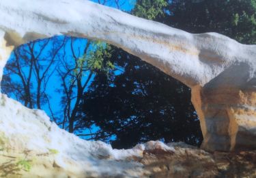
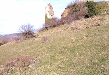
Bonne grimpette pour aller au col. Départ et arrivée au camping. Raccourci après église de Comps pas terrible. Prendre plutôt la route qui passe par la mairie de Comps.
Ort
Land:
France
Region :
Auvergne-Rhone-Alpen
Abteilung/Provinz :
Drôme
Kommune :
Comps
Standort:
Unknown
Gehen Sie:(Dec)
Gehen Sie:(UTM)
665848 ; 4935280 (31T) N.
Kommentare
Touren in der Umgebung
![Tour Wandern Montjoux - Le Devès - Montjoux - Photo](https://media.geolcdn.com/t/375/260/ext.jpg?maxdim=2&url=https%3A%2F%2Fservices.sitytrail.com%2FGeolivesWS%2FDownloadMedia.ashx%3FTrailID%3D172804%26Media%3D14234_5.jpg)
![Wandern Wandern](https://static1.geolcdn.com/sitytour/trail-icons/101.png)
Le Devès - Montjoux
Wandern
Einfach
(1)
Montjoux,
Auvergne-Rhone-Alpen,
Drôme,
France
![](/images/other/stat-length.png)
5,3 km | 7 km-effort
1h 19min
![](https://static1.geolcdn.com/siteimages/upload/files/16400158638029165_repeat_loop_refresh_sync_direction_icon.png)
Ja
![Tour Wandern Dieulefit - 26 dieulefit chap st Maurice vitrouilleres - Photo](https://media.geolcdn.com/t/375/260/9032ba92-359b-417c-8863-3a326ab807ba.jpg&format=jpg&maxdim=2)
![Wandern Wandern](https://static1.geolcdn.com/sitytour/trail-icons/101.png)
26 dieulefit chap st Maurice vitrouilleres
Wandern
Einfach
Dieulefit,
Auvergne-Rhone-Alpen,
Drôme,
France
![](/images/other/stat-length.png)
13,8 km | 23 km-effort
6h 17min
![](https://static1.geolcdn.com/siteimages/upload/files/16400158638029165_repeat_loop_refresh_sync_direction_icon.png)
Ja
![Tour Wandern Rochebaudin - Rochebaudin-Trou du Furet-Serre Gros 16km - Photo](https://media.geolcdn.com/t/375/260/dc7160ec-c951-47bb-8de8-e15fab760352.jpg&format=jpg&maxdim=2)
![Wandern Wandern](https://static1.geolcdn.com/sitytour/trail-icons/101.png)
Rochebaudin-Trou du Furet-Serre Gros 16km
Wandern
Schwierig
Rochebaudin,
Auvergne-Rhone-Alpen,
Drôme,
France
![](/images/other/stat-length.png)
15,8 km | 26 km-effort
5h 0min
![](https://static1.geolcdn.com/siteimages/upload/files/16400158638029165_repeat_loop_refresh_sync_direction_icon.png)
Ja
![Tour Wandern Dieulefit - 2022-09-03_11h50m30_Chapelle St Maurice 10km.gpx (3).xml - Photo](https://media.geolcdn.com/t/375/260/70a2cb51-e6fc-4007-ba36-e4a050e05f72.jpg&format=jpg&maxdim=2)
![Wandern Wandern](https://static1.geolcdn.com/sitytour/trail-icons/101.png)
2022-09-03_11h50m30_Chapelle St Maurice 10km.gpx (3).xml
Wandern
Schwierig
Dieulefit,
Auvergne-Rhone-Alpen,
Drôme,
France
![](/images/other/stat-length.png)
10 km | 17,1 km-effort
3h 53min
![](https://static1.geolcdn.com/siteimages/upload/files/16400158638029165_repeat_loop_refresh_sync_direction_icon.png)
Ja
![Tour Wandern Dieulefit - Chapelle saint Maurice par le sentier du cochon - Photo](https://media.geolcdn.com/t/375/260/cf0b1613-8f56-44df-807b-db512561a354.jpg&format=jpg&maxdim=2)
![Wandern Wandern](https://static1.geolcdn.com/sitytour/trail-icons/101.png)
Chapelle saint Maurice par le sentier du cochon
Wandern
Schwierig
Dieulefit,
Auvergne-Rhone-Alpen,
Drôme,
France
![](/images/other/stat-length.png)
10,9 km | 17,9 km-effort
4h 40min
![](https://static1.geolcdn.com/siteimages/upload/files/16400158638029165_repeat_loop_refresh_sync_direction_icon.png)
Ja
![Tour Wandern Comps - 2024-03-07_12h38m09_Orcinas 14km - Photo](https://media.geolcdn.com/t/375/260/d29c1d85-ffea-4497-9bab-1cce45a06780.jpg&format=jpg&maxdim=2)
![Wandern Wandern](https://static1.geolcdn.com/sitytour/trail-icons/101.png)
2024-03-07_12h38m09_Orcinas 14km
Wandern
Sehr schwierig
Comps,
Auvergne-Rhone-Alpen,
Drôme,
France
![](/images/other/stat-length.png)
14,1 km | 22 km-effort
4h 54min
![](https://static1.geolcdn.com/siteimages/upload/files/16400158638029165_repeat_loop_refresh_sync_direction_icon.png)
Ja
![Tour Wandern Dieulefit - Vitrouillières Dieulefit - Photo](https://media.geolcdn.com/t/375/260/11bc24d8-15a9-487b-bcda-b3a093eafbe9.jpg&format=jpg&maxdim=2)
![Wandern Wandern](https://static1.geolcdn.com/sitytour/trail-icons/101.png)
Vitrouillières Dieulefit
Wandern
Medium
Dieulefit,
Auvergne-Rhone-Alpen,
Drôme,
France
![](/images/other/stat-length.png)
14,8 km | 25 km-effort
4h 28min
![](https://static1.geolcdn.com/siteimages/upload/files/16400158638029165_repeat_loop_refresh_sync_direction_icon.png)
Ja
![Tour Wandern Bourdeaux - 26 bourreaux huguenot 31.12.22 - Photo](https://media.geolcdn.com/t/375/260/d3bd89ec-167b-4d96-a78d-b5b047518271.jpg&format=jpg&maxdim=2)
![Wandern Wandern](https://static1.geolcdn.com/sitytour/trail-icons/101.png)
26 bourreaux huguenot 31.12.22
Wandern
Medium
Bourdeaux,
Auvergne-Rhone-Alpen,
Drôme,
France
![](/images/other/stat-length.png)
15 km | 23 km-effort
5h 45min
![](https://static1.geolcdn.com/siteimages/upload/files/16400158638029165_repeat_loop_refresh_sync_direction_icon.png)
Nein
![Tour Wandern Dieulefit - 2022-09-03_11h49m50_Tour des 3 montagnes 18km.gpx.xml - Photo](https://media.geolcdn.com/t/375/260/14536835-7996-47e3-9b26-05b81d5d9fd5.jpg&format=jpg&maxdim=2)
![Wandern Wandern](https://static1.geolcdn.com/sitytour/trail-icons/101.png)
2022-09-03_11h49m50_Tour des 3 montagnes 18km.gpx.xml
Wandern
Schwierig
Dieulefit,
Auvergne-Rhone-Alpen,
Drôme,
France
![](/images/other/stat-length.png)
18 km | 26 km-effort
5h 50min
![](https://static1.geolcdn.com/siteimages/upload/files/16400158638029165_repeat_loop_refresh_sync_direction_icon.png)
Ja