![](/images/other/stat-length.png)
![Tour Wandern Bourg-Saint-Maurice - Arcs 1600 - Les deux têtes - Photo](https://media.geolcdn.com/t/1900/400/ext.pjpeg?maxdim=2&url=https%3A%2F%2Fstatic1.geolcdn.com%2Fsiteimages%2Fupload%2Ffiles%2F1553511878bg_sport_marche.png)
Arcs 1600 - Les deux têtes
bob2023
Benutzer
![Länge](/images/other/stat-length.png)
Länge
7,6 km
![Maximale Höhe](https://static1.geolcdn.com/siteimages/upload/files/1508320355ic_sort_altitude_max_24dp.png)
Maximale Höhe
2371 m
![Positive Höhendifferenz](https://static1.geolcdn.com/siteimages/upload/files/1508320355ic_sort_den_pos_24dp.png)
Positive Höhendifferenz
204 m
![Km-Effort](/images/other/stat-length.png)
Km-Effort
12,2 km
![Min. Höhe](https://static1.geolcdn.com/siteimages/upload/files/1508320355ic_sort_altitude_min_24dp.png)
Min. Höhe
1618 m
![Negative Höhendifferenz](https://static1.geolcdn.com/siteimages/upload/files/1508320355ic_sort_den_neg_24dp.png)
Negative Höhendifferenz
757 m
![Boucle](https://static1.geolcdn.com/siteimages/upload/files/16400158638029165_repeat_loop_refresh_sync_direction_icon.png)
Boucle
Nein
Erstellungsdatum :
2018-08-26 08:31:57.593
Letzte Änderung :
2018-08-26 08:31:57.603
![Wandern](https://static1.geolcdn.com/sitytour/trail-icons/101.png)
2h15
Schwierigkeit : Medium
![Scannen Sie diesen QR-Code, um die Tour in der SityTrail-Anwendung zu öffnen](https://capi.geolives.com/qq0zvz2zws4bq2lad0pu/sitytour/trails/778859/qr.png?size=200)
Kostenlosegpshiking-Anwendung
Über SityTrail
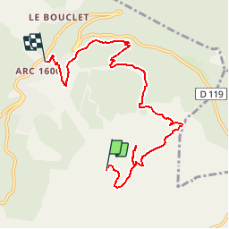
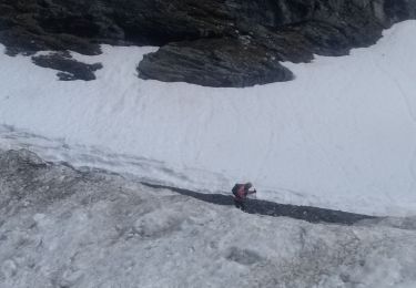
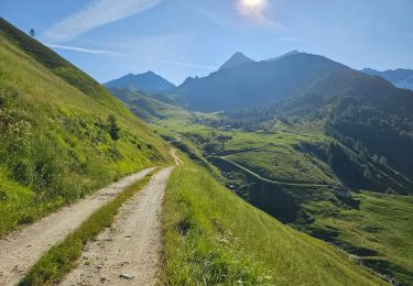
Tour Wandern von 7,6 km verfügbar auf Auvergne-Rhone-Alpen, Savoyen, Bourg-Saint-Maurice. Diese Tour wird von bob2023 vorgeschlagen.
Beschreibung
prendre le telesiege de la cachette. Magnifique rando, possibilité de voir des marmottes.
une seule montée, courte mais raide, prévoir de bonnes chaussure tout de même pour la descente.
Ort
Land:
France
Region :
Auvergne-Rhone-Alpen
Abteilung/Provinz :
Savoyen
Kommune :
Bourg-Saint-Maurice
Standort:
Unknown
Gehen Sie:(Dec)
Gehen Sie:(UTM)
328868 ; 5050045 (32T) N.
Kommentare
Touren in der Umgebung
![Tour Wandern Landry - Landry... Circuit des Poussettes - Photo](https://media.geolcdn.com/t/375/260/7036f5a0-5897-408b-aec5-74b6e9af163d.jpeg&format=jpg&maxdim=2)
![Wandern Wandern](https://static1.geolcdn.com/sitytour/trail-icons/101.png)
Landry... Circuit des Poussettes
Wandern
(1)
Landry,
Auvergne-Rhone-Alpen,
Savoyen,
France
![](/images/other/stat-length.png)
4,6 km | 6,2 km-effort
2h 50min
![](https://static1.geolcdn.com/siteimages/upload/files/16400158638029165_repeat_loop_refresh_sync_direction_icon.png)
Nein
![Tour Wandern Bourg-Saint-Maurice - Le sentier balcon des sources de l'Arbonne - Photo](https://media.geolcdn.com/t/375/260/ext.jpg?maxdim=2&url=https%3A%2F%2Fstatic1.geolcdn.com%2Fsiteimages%2Fupload%2Ffiles%2F1553511878bg_sport_marche.png)
![Wandern Wandern](https://static1.geolcdn.com/sitytour/trail-icons/101.png)
Le sentier balcon des sources de l'Arbonne
Wandern
Schwierig
(1)
Bourg-Saint-Maurice,
Auvergne-Rhone-Alpen,
Savoyen,
France
![](/images/other/stat-length.png)
14,1 km | 24 km-effort
5h 26min
![](https://static1.geolcdn.com/siteimages/upload/files/16400158638029165_repeat_loop_refresh_sync_direction_icon.png)
Ja
![Tour Skiwanderen Montvalezan - Pointe des couloureuses couloir ouest du passage du Retour - Photo](https://media.geolcdn.com/t/375/260/3e3eb199-e795-49ca-ade2-348294ef2b6d.jpg&format=jpg&maxdim=2)
![Skiwanderen Skiwanderen](https://static1.geolcdn.com/sitytour/trail-icons/503.png)
Pointe des couloureuses couloir ouest du passage du Retour
Skiwanderen
Medium
Montvalezan,
Auvergne-Rhone-Alpen,
Savoyen,
France
![](/images/other/stat-length.png)
12 km | 29 km-effort
5h 5min
![](https://static1.geolcdn.com/siteimages/upload/files/16400158638029165_repeat_loop_refresh_sync_direction_icon.png)
Ja
![Tour Skiwanderen Bourg-Saint-Maurice - Le grand Châtelet Est en boucle - Photo](https://media.geolcdn.com/t/375/260/6b25a155-1df9-4a43-bfdb-3a7483c7ae4a.jpg&format=jpg&maxdim=2)
![Skiwanderen Skiwanderen](https://static1.geolcdn.com/sitytour/trail-icons/503.png)
Le grand Châtelet Est en boucle
Skiwanderen
Medium
Bourg-Saint-Maurice,
Auvergne-Rhone-Alpen,
Savoyen,
France
![](/images/other/stat-length.png)
14,9 km | 32 km-effort
6h 0min
![](https://static1.geolcdn.com/siteimages/upload/files/16400158638029165_repeat_loop_refresh_sync_direction_icon.png)
Ja
![Tour Skiwanderen Bourg-Saint-Maurice - col des roches vers le Pourri - Photo](https://media.geolcdn.com/t/375/260/1b6a1c42-133a-4e34-bc5c-807990c98faf.jpg&format=jpg&maxdim=2)
![Skiwanderen Skiwanderen](https://static1.geolcdn.com/sitytour/trail-icons/503.png)
col des roches vers le Pourri
Skiwanderen
Schwierig
Bourg-Saint-Maurice,
Auvergne-Rhone-Alpen,
Savoyen,
France
![](/images/other/stat-length.png)
13,2 km | 29 km-effort
6h 0min
![](https://static1.geolcdn.com/siteimages/upload/files/16400158638029165_repeat_loop_refresh_sync_direction_icon.png)
Ja
![Tour Wandern Peisey-Nancroix - la chapelle - Photo](https://media.geolcdn.com/t/375/260/7d1a0a4e-297d-405a-8b27-d2ee45329ab1.jpg&format=jpg&maxdim=2)
![Wandern Wandern](https://static1.geolcdn.com/sitytour/trail-icons/101.png)
la chapelle
Wandern
Sehr leicht
(1)
Peisey-Nancroix,
Auvergne-Rhone-Alpen,
Savoyen,
France
![](/images/other/stat-length.png)
4,8 km | 7,3 km-effort
1h 34min
![](https://static1.geolcdn.com/siteimages/upload/files/16400158638029165_repeat_loop_refresh_sync_direction_icon.png)
Ja
![Tour Wandern Bourg-Saint-Maurice - arc 1950 col des frettes arc 1800 station internationale - Photo](https://media.geolcdn.com/t/375/260/f895417e-d75f-415c-875d-31cc9f0b4878.jpg&format=jpg&maxdim=2)
![Wandern Wandern](https://static1.geolcdn.com/sitytour/trail-icons/101.png)
arc 1950 col des frettes arc 1800 station internationale
Wandern
Sehr leicht
(1)
Bourg-Saint-Maurice,
Auvergne-Rhone-Alpen,
Savoyen,
France
![](/images/other/stat-length.png)
6,2 km | 11,8 km-effort
2h 10min
![](https://static1.geolcdn.com/siteimages/upload/files/16400158638029165_repeat_loop_refresh_sync_direction_icon.png)
Nein
![Tour Schneeschuhwandern Peisey-Nancroix - Le sanctuaire des Vernettes - Photo](https://media.geolcdn.com/t/375/260/ext.jpg?maxdim=2&url=https%3A%2F%2Fservices.sitytrail.com%2FGeolivesWS%2FDownloadMedia.ashx%3FTrailID%3D912513%26Media%3Daf40344a-d6c9-4ee4-96b9-8f0082ef4938.JPG)
![Schneeschuhwandern Schneeschuhwandern](https://static1.geolcdn.com/sitytour/trail-icons/504.png)
Le sanctuaire des Vernettes
Schneeschuhwandern
Einfach
Peisey-Nancroix,
Auvergne-Rhone-Alpen,
Savoyen,
France
![](/images/other/stat-length.png)
5,8 km | 8,4 km-effort
2h 0min
![](https://static1.geolcdn.com/siteimages/upload/files/16400158638029165_repeat_loop_refresh_sync_direction_icon.png)
Ja
![Tour Wandern Peisey-Nancroix - Peisey Vallandry Les Rossets Col d'Entreporte - Photo](https://media.geolcdn.com/t/375/260/13ebbf20-1090-4544-9f75-ac1ab2a608ef.jpg&format=jpg&maxdim=2)
![Wandern Wandern](https://static1.geolcdn.com/sitytour/trail-icons/101.png)
Peisey Vallandry Les Rossets Col d'Entreporte
Wandern
Schwierig
Peisey-Nancroix,
Auvergne-Rhone-Alpen,
Savoyen,
France
![](/images/other/stat-length.png)
14,3 km | 26 km-effort
4h 51min
![](https://static1.geolcdn.com/siteimages/upload/files/16400158638029165_repeat_loop_refresh_sync_direction_icon.png)
Ja