![](/images/other/stat-length.png)
![Tour Wandern Rabou - Circuit des gorges du petit Buech. 01 06 13 - Photo](https://media.geolcdn.com/t/1900/400/ext.pjpeg?maxdim=2&url=https%3A%2F%2Fstatic1.geolcdn.com%2Fsiteimages%2Fupload%2Ffiles%2F1553511878bg_sport_marche.png)
Circuit des gorges du petit Buech. 01 06 13
Dervalmarc
Benutzer
![Länge](/images/other/stat-length.png)
![Maximale Höhe](https://static1.geolcdn.com/siteimages/upload/files/1508320355ic_sort_altitude_max_24dp.png)
![Positive Höhendifferenz](https://static1.geolcdn.com/siteimages/upload/files/1508320355ic_sort_den_pos_24dp.png)
![Km-Effort](/images/other/stat-length.png)
![Min. Höhe](https://static1.geolcdn.com/siteimages/upload/files/1508320355ic_sort_altitude_min_24dp.png)
![Negative Höhendifferenz](https://static1.geolcdn.com/siteimages/upload/files/1508320355ic_sort_den_neg_24dp.png)
![Boucle](https://static1.geolcdn.com/siteimages/upload/files/16400158638029165_repeat_loop_refresh_sync_direction_icon.png)
![Wandern](https://static1.geolcdn.com/sitytour/trail-icons/101.png)
4h30
Schwierigkeit : Schwierig
![Scannen Sie diesen QR-Code, um die Tour in der SityTrail-Anwendung zu öffnen](https://capi.geolives.com/qq0zvz2zws4bq2lad0pu/sitytour/trails/762015/qr.png?size=200)
Kostenlosegpshiking-Anwendung
Über SityTrail
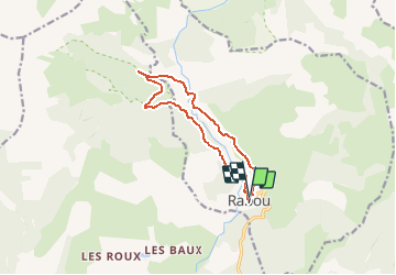
Tour Wandern von 10,9 km verfügbar auf Provence-Alpes-Côte d'Azur, Hochalpen, Rabou. Diese Tour wird von Dervalmarc vorgeschlagen.
Beschreibung
Depuis le hameau perché de Rabou, cette randonnée permet de découvrir les gorges du Petit-Buëch, l’impressionnant sentier des Bans taillé à flanc de falaise et la chapelle de la Crotte.Quand on va à RABOU, on se doit d'aller voir le très célèbre SENTIER des BANS. Et
c'est vrai que le passage taillé dans le rocher de ce sentier est impressionnant.Voilà une jolie randonnée , mais compte tenu des passages délicats rencontrés , elle ne s'adresse qu'à des randonneurs confirmés, et surtout n'y allez pas seul.
Ort
Kommentare
Touren in der Umgebung
![Tour Wandern Gap - Brèche et croix de Charance - Photo](https://media.geolcdn.com/t/375/260/ext.jpg?maxdim=2&url=https%3A%2F%2Fservices.sitytrail.com%2FGeolivesWS%2FDownloadMedia.ashx%3FTrailID%3D95802%26Media%3D20111201151419.jpg)
![Wandern Wandern](https://static1.geolcdn.com/sitytour/trail-icons/101.png)
Wandern
![](/images/other/stat-length.png)
![](https://static1.geolcdn.com/siteimages/upload/files/16400158638029165_repeat_loop_refresh_sync_direction_icon.png)
![Tour Wandern Rabou - Rabou Tour du Puy - Photo](https://media.geolcdn.com/t/375/260/805e1ce0-378d-4868-bdbb-2f6f352f7b11.jpg&format=jpg&maxdim=2)
![Wandern Wandern](https://static1.geolcdn.com/sitytour/trail-icons/101.png)
Wandern
![](/images/other/stat-length.png)
![](https://static1.geolcdn.com/siteimages/upload/files/16400158638029165_repeat_loop_refresh_sync_direction_icon.png)
![Tour Wandern Gap - Pic de Charance - Photo](https://media.geolcdn.com/t/375/260/1b819787-5cbc-4e39-b2ee-7b1b220b0af8.jpg&format=jpg&maxdim=2)
![Wandern Wandern](https://static1.geolcdn.com/sitytour/trail-icons/101.png)
Wandern
![](/images/other/stat-length.png)
![](https://static1.geolcdn.com/siteimages/upload/files/16400158638029165_repeat_loop_refresh_sync_direction_icon.png)
![Tour Wandern Rabou - Pic Melette - Photo](https://media.geolcdn.com/t/375/260/4622a0c3-66f1-414b-9c6c-2d569eb751b3.jpg&format=jpg&maxdim=2)
![Wandern Wandern](https://static1.geolcdn.com/sitytour/trail-icons/101.png)
Wandern
![](/images/other/stat-length.png)
![](https://static1.geolcdn.com/siteimages/upload/files/16400158638029165_repeat_loop_refresh_sync_direction_icon.png)
![Tour Wandern Gap - Pic de Gleize - Photo](https://media.geolcdn.com/t/375/260/9b3dcddd-15e9-4793-a987-aa74cd6c203d.jpg&format=jpg&maxdim=2)
![Wandern Wandern](https://static1.geolcdn.com/sitytour/trail-icons/101.png)
Wandern
![](/images/other/stat-length.png)
![](https://static1.geolcdn.com/siteimages/upload/files/16400158638029165_repeat_loop_refresh_sync_direction_icon.png)
![Tour Wandern Gap - Cuchon-Pic de Charance - Photo](https://media.geolcdn.com/t/375/260/273370c5-f091-46d0-92ed-fb2a447f25db.jpg&format=jpg&maxdim=2)
![Wandern Wandern](https://static1.geolcdn.com/sitytour/trail-icons/101.png)
Wandern
![](/images/other/stat-length.png)
![](https://static1.geolcdn.com/siteimages/upload/files/16400158638029165_repeat_loop_refresh_sync_direction_icon.png)
![Tour Wandern Gap - Col de Guizière - Photo](https://media.geolcdn.com/t/375/260/48c56f83-5df5-469d-a27d-85eb85489bb3.jpg&format=jpg&maxdim=2)
![Wandern Wandern](https://static1.geolcdn.com/sitytour/trail-icons/101.png)
Wandern
![](/images/other/stat-length.png)
![](https://static1.geolcdn.com/siteimages/upload/files/16400158638029165_repeat_loop_refresh_sync_direction_icon.png)
![Tour Mountainbike La Roche-des-Arnauds - La Rivière - Photo](https://media.geolcdn.com/t/375/260/0a9ee634-fce3-4af5-9c6a-1f11e946fd54.jpg&format=jpg&maxdim=2)
![Mountainbike Mountainbike](https://static1.geolcdn.com/sitytour/trail-icons/202.png)
Mountainbike
![](/images/other/stat-length.png)
![](https://static1.geolcdn.com/siteimages/upload/files/16400158638029165_repeat_loop_refresh_sync_direction_icon.png)
![Tour Zu Fuß Rabou - 9587041 - Photo](https://media.geolcdn.com/t/375/260/6a1636b4-b223-413d-a187-700130d298fe.jpg&format=jpg&maxdim=2)
![Zu Fuß Zu Fuß](https://static1.geolcdn.com/sitytour/trail-icons/100.png)
Zu Fuß
![](/images/other/stat-length.png)
![](https://static1.geolcdn.com/siteimages/upload/files/16400158638029165_repeat_loop_refresh_sync_direction_icon.png)