![](/images/other/stat-length.png)
![Tour Wandern Charquemont - gorges du Doubs - Photo](https://media.geolcdn.com/t/1900/400/ext.pjpeg?maxdim=2&url=https%3A%2F%2Fservices.sitytrail.com%2FGeolivesWS%2FDownloadMedia.ashx%3FTrailID%3D759641%26Media%3Dfix__20170525134753.jpg)
gorges du Doubs
jibus90
Benutzer
![Länge](/images/other/stat-length.png)
Länge
12,2 km
![Maximale Höhe](https://static1.geolcdn.com/siteimages/upload/files/1508320355ic_sort_altitude_max_24dp.png)
Maximale Höhe
916 m
![Positive Höhendifferenz](https://static1.geolcdn.com/siteimages/upload/files/1508320355ic_sort_den_pos_24dp.png)
Positive Höhendifferenz
555 m
![Km-Effort](/images/other/stat-length.png)
Km-Effort
19,6 km
![Min. Höhe](https://static1.geolcdn.com/siteimages/upload/files/1508320355ic_sort_altitude_min_24dp.png)
Min. Höhe
548 m
![Negative Höhendifferenz](https://static1.geolcdn.com/siteimages/upload/files/1508320355ic_sort_den_neg_24dp.png)
Negative Höhendifferenz
558 m
![Boucle](https://static1.geolcdn.com/siteimages/upload/files/16400158638029165_repeat_loop_refresh_sync_direction_icon.png)
Boucle
Nein
Erstellungsdatum :
2018-09-30 18:57:48.088
Letzte Änderung :
2018-09-30 18:57:48.191
![Wandern](https://static1.geolcdn.com/sitytour/trail-icons/101.png)
3h36
Schwierigkeit : Medium
![Scannen Sie diesen QR-Code, um die Tour in der SityTrail-Anwendung zu öffnen](https://capi.geolives.com/qq0zvz2zws4bq2lad0pu/sitytour/trails/759641/qr.png?size=200)
Kostenlosegpshiking-Anwendung
Über SityTrail
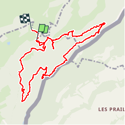
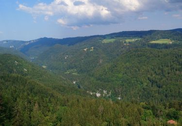
Tour Wandern von 12,2 km verfügbar auf Burgund und Freigrafschaft, Doubs, Charquemont. Diese Tour wird von jibus90 vorgeschlagen.
Beschreibung
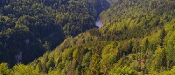
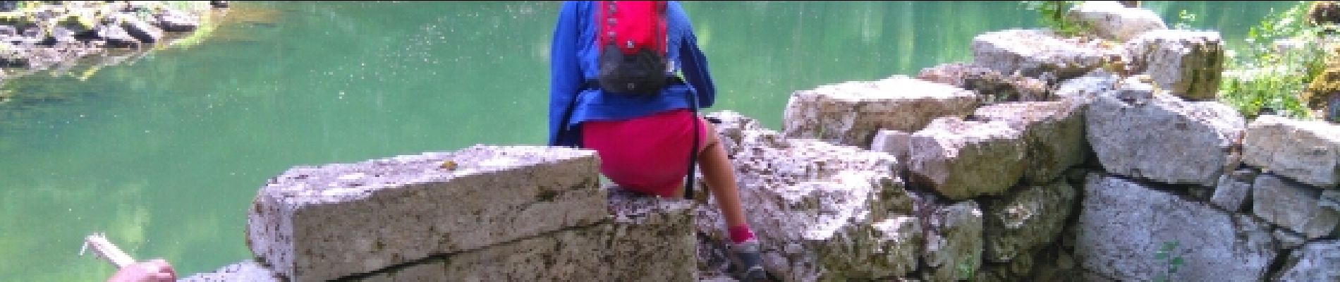
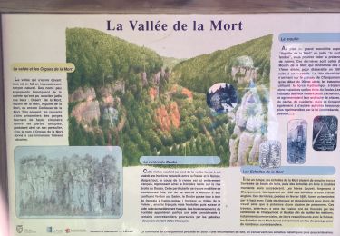
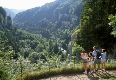
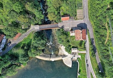
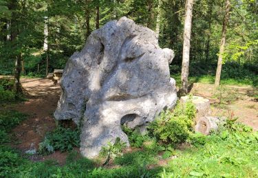
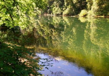
belle descente vers le Doubs un petit pique nique
Ort
Land:
France
Region :
Burgund und Freigrafschaft
Abteilung/Provinz :
Doubs
Kommune :
Charquemont
Standort:
Unknown
Gehen Sie:(Dec)
Gehen Sie:(UTM)
339300 ; 5230672 (32T) N.
Kommentare
Touren in der Umgebung
![Tour Wandern Charquemont - Échelles de la mort - Photo](https://media.geolcdn.com/t/375/260/7b9848bb-a43e-4c47-8544-5e7b63b496f6.jpg&format=jpg&maxdim=2)
![Wandern Wandern](https://static1.geolcdn.com/sitytour/trail-icons/101.png)
Échelles de la mort
Wandern
Medium
(1)
Charquemont,
Burgund und Freigrafschaft,
Doubs,
France
![](/images/other/stat-length.png)
6,5 km | 9,5 km-effort
1h 33min
![](https://static1.geolcdn.com/siteimages/upload/files/16400158638029165_repeat_loop_refresh_sync_direction_icon.png)
Ja
![Tour Wandern Charquemont - Les Echelles de la Mort - Doubs - Photo](https://media.geolcdn.com/t/375/260/ext.jpg?maxdim=2&url=https%3A%2F%2Fservices.sitytrail.com%2FGeolivesWS%2FDownloadMedia.ashx%3FTrailID%3D108929%26Media%3D2620_1.jpg)
![Wandern Wandern](https://static1.geolcdn.com/sitytour/trail-icons/101.png)
Les Echelles de la Mort - Doubs
Wandern
Medium
(2)
Charquemont,
Burgund und Freigrafschaft,
Doubs,
France
![](/images/other/stat-length.png)
8,4 km | 14,1 km-effort
3h 0min
![](https://static1.geolcdn.com/siteimages/upload/files/16400158638029165_repeat_loop_refresh_sync_direction_icon.png)
Ja
![Tour Zu Fuß Le Noirmont - La Goule - fixme - Photo](https://media.geolcdn.com/t/375/260/26c9f498-14fd-470d-95fd-f93787b84ec0.jpeg&format=jpg&maxdim=2)
![Zu Fuß Zu Fuß](https://static1.geolcdn.com/sitytour/trail-icons/100.png)
La Goule - fixme
Zu Fuß
Einfach
Le Noirmont,
Jura,
Freiberge,
Switzerland
![](/images/other/stat-length.png)
3,4 km | 4,5 km-effort
1h 0min
![](https://static1.geolcdn.com/siteimages/upload/files/16400158638029165_repeat_loop_refresh_sync_direction_icon.png)
Nein
![Tour Zu Fuß Le Noirmont - La Goule - fixme - Photo](https://media.geolcdn.com/t/375/260/26c9f498-14fd-470d-95fd-f93787b84ec0.jpeg&format=jpg&maxdim=2)
![Zu Fuß Zu Fuß](https://static1.geolcdn.com/sitytour/trail-icons/100.png)
La Goule - fixme
Zu Fuß
Einfach
Le Noirmont,
Jura,
Freiberge,
Switzerland
![](/images/other/stat-length.png)
3,9 km | 8,2 km-effort
1h 51min
![](https://static1.geolcdn.com/siteimages/upload/files/16400158638029165_repeat_loop_refresh_sync_direction_icon.png)
Nein
![Tour sport Charquemont - Charquemont - Photo](https://media.geolcdn.com/t/375/260/2f6ea34c-c41e-4747-afa9-f8bc25b75ed3.jpg&format=jpg&maxdim=2)
Charquemont
sport
Sehr leicht
Charquemont,
Burgund und Freigrafschaft,
Doubs,
France
![](/images/other/stat-length.png)
5,5 km | 7,9 km-effort
Unbekannt
![](https://static1.geolcdn.com/siteimages/upload/files/16400158638029165_repeat_loop_refresh_sync_direction_icon.png)
Ja
![Tour Wandern Charquemont - lçendre cha4quemond - Photo](https://media.geolcdn.com/t/375/260/d4b171d3-4707-4b81-9ad5-a84cf10f6378.jpg&format=jpg&maxdim=2)
![Wandern Wandern](https://static1.geolcdn.com/sitytour/trail-icons/101.png)
lçendre cha4quemond
Wandern
Sehr schwierig
Charquemont,
Burgund und Freigrafschaft,
Doubs,
France
![](/images/other/stat-length.png)
13,2 km | 22 km-effort
5h 55min
![](https://static1.geolcdn.com/siteimages/upload/files/16400158638029165_repeat_loop_refresh_sync_direction_icon.png)
Ja
![Tour Wandern Charquemont - Combes Saint Pierre - Photo](https://media.geolcdn.com/t/375/260/0b54ab85-de60-4572-870a-d1ef0de23798.jpg&format=jpg&maxdim=2)
![Wandern Wandern](https://static1.geolcdn.com/sitytour/trail-icons/101.png)
Combes Saint Pierre
Wandern
Einfach
(1)
Charquemont,
Burgund und Freigrafschaft,
Doubs,
France
![](/images/other/stat-length.png)
5,9 km | 8 km-effort
3h 29min
![](https://static1.geolcdn.com/siteimages/upload/files/16400158638029165_repeat_loop_refresh_sync_direction_icon.png)
Ja
![Tour Wandern Charquemont - Goumois-Le Boulois / Les échelles de la mort - Photo](https://media.geolcdn.com/t/375/260/e486823a-bed9-43a4-abeb-bf237649de07.jpg&format=jpg&maxdim=2)
![Wandern Wandern](https://static1.geolcdn.com/sitytour/trail-icons/101.png)
Goumois-Le Boulois / Les échelles de la mort
Wandern
Medium
Charquemont,
Burgund und Freigrafschaft,
Doubs,
France
![](/images/other/stat-length.png)
15,9 km | 26 km-effort
3h 14min
![](https://static1.geolcdn.com/siteimages/upload/files/16400158638029165_repeat_loop_refresh_sync_direction_icon.png)
Ja
![Tour Wandern Charmauvillers - Goumois randonnée La Goule - Photo](https://media.geolcdn.com/t/375/260/21b4c51b-c2b4-4e0c-a0c1-612025391c50.jpg&format=jpg&maxdim=2)
![Wandern Wandern](https://static1.geolcdn.com/sitytour/trail-icons/101.png)
Goumois randonnée La Goule
Wandern
Medium
Charmauvillers,
Burgund und Freigrafschaft,
Doubs,
France
![](/images/other/stat-length.png)
19,6 km | 35 km-effort
3h 5min
![](https://static1.geolcdn.com/siteimages/upload/files/16400158638029165_repeat_loop_refresh_sync_direction_icon.png)
Nein