![](/images/other/stat-length.png)
![Tour Wandern Briare - Rando du pont canal - Photo](https://media.geolcdn.com/t/1900/400/ext.pjpeg?maxdim=2&url=https%3A%2F%2Fstatic1.geolcdn.com%2Fsiteimages%2Fupload%2Ffiles%2F1553511878bg_sport_marche.png)
Rando du pont canal
Ordijamo45
Benutzer
![Länge](/images/other/stat-length.png)
Länge
11,9 km
![Maximale Höhe](https://static1.geolcdn.com/siteimages/upload/files/1508320355ic_sort_altitude_max_24dp.png)
Maximale Höhe
144 m
![Positive Höhendifferenz](https://static1.geolcdn.com/siteimages/upload/files/1508320355ic_sort_den_pos_24dp.png)
Positive Höhendifferenz
92 m
![Km-Effort](/images/other/stat-length.png)
Km-Effort
13,1 km
![Min. Höhe](https://static1.geolcdn.com/siteimages/upload/files/1508320355ic_sort_altitude_min_24dp.png)
Min. Höhe
117 m
![Negative Höhendifferenz](https://static1.geolcdn.com/siteimages/upload/files/1508320355ic_sort_den_neg_24dp.png)
Negative Höhendifferenz
92 m
![Boucle](https://static1.geolcdn.com/siteimages/upload/files/16400158638029165_repeat_loop_refresh_sync_direction_icon.png)
Boucle
Ja
Erstellungsdatum :
2019-05-03 09:14:50.007
Letzte Änderung :
2019-05-03 09:14:50.086
![Wandern](https://static1.geolcdn.com/sitytour/trail-icons/101.png)
2h29
Schwierigkeit : Einfach
![Scannen Sie diesen QR-Code, um die Tour in der SityTrail-Anwendung zu öffnen](https://capi.geolives.com/qq0zvz2zws4bq2lad0pu/sitytour/trails/752549/qr.png?size=200)
Kostenlosegpshiking-Anwendung
Über SityTrail
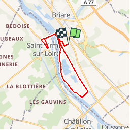
Tour Wandern von 11,9 km verfügbar auf Zentrum-Loiretal, Loiret, Briare. Diese Tour wird von Ordijamo45 vorgeschlagen.
Beschreibung
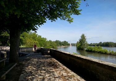
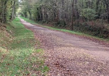
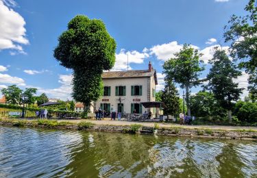
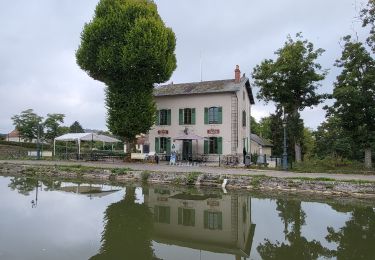
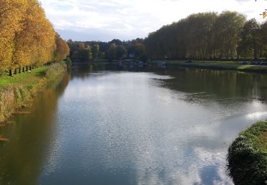
Départ de la salle Jean Jaurès rue de l’industrie de Briare (45) belle rando surtout sur le retour par le bord de Loire
Ort
Land:
France
Region :
Zentrum-Loiretal
Abteilung/Provinz :
Loiret
Kommune :
Briare
Standort:
Unknown
Gehen Sie:(Dec)
Gehen Sie:(UTM)
480952 ; 5274936 (31T) N.
Kommentare
Touren in der Umgebung
![Tour Wandern Briare - Le Pont-canal de Briare - Photo](https://media.geolcdn.com/t/375/260/ext.jpg?maxdim=2&url=https%3A%2F%2Fservices.sitytrail.com%2FGeolivesWS%2FDownloadMedia.ashx%3FTrailID%3D419085%26Media%3Dfix__20150510104912.jpg)
![Wandern Wandern](https://static1.geolcdn.com/sitytour/trail-icons/101.png)
Le Pont-canal de Briare
Wandern
Einfach
(1)
Briare,
Zentrum-Loiretal,
Loiret,
France
![](/images/other/stat-length.png)
16,6 km | 18,7 km-effort
3h 36min
![](https://static1.geolcdn.com/siteimages/upload/files/16400158638029165_repeat_loop_refresh_sync_direction_icon.png)
Ja
![Tour Radtourismus Briare - Châtillon sur Loire à Sully sur Loire - Photo](https://media.geolcdn.com/t/375/260/c67c7e2f-d5af-4f8a-b506-4dd8df7701bc.jpg&format=jpg&maxdim=2)
![Radtourismus Radtourismus](https://static1.geolcdn.com/sitytour/trail-icons/204.png)
Châtillon sur Loire à Sully sur Loire
Radtourismus
Medium
Briare,
Zentrum-Loiretal,
Loiret,
France
![](/images/other/stat-length.png)
52 km | 57 km-effort
4h 15min
![](https://static1.geolcdn.com/siteimages/upload/files/16400158638029165_repeat_loop_refresh_sync_direction_icon.png)
Nein
![Tour Wandern Briare - de Briare au camping de Gien - Photo](https://media.geolcdn.com/t/375/260/e5e9df33-8dc3-4d75-b21b-f2ad212b1f99.jpg&format=jpg&maxdim=2)
![Wandern Wandern](https://static1.geolcdn.com/sitytour/trail-icons/101.png)
de Briare au camping de Gien
Wandern
Schwierig
Briare,
Zentrum-Loiretal,
Loiret,
France
![](/images/other/stat-length.png)
16,7 km | 19 km-effort
5h 54min
![](https://static1.geolcdn.com/siteimages/upload/files/16400158638029165_repeat_loop_refresh_sync_direction_icon.png)
Nein
![Tour Wandern Briare - Troussebois - Photo](https://media.geolcdn.com/t/375/260/278cbec8-6df4-41a8-bf76-164dc1cc1650.jpg&format=jpg&maxdim=2)
![Wandern Wandern](https://static1.geolcdn.com/sitytour/trail-icons/101.png)
Troussebois
Wandern
Sehr leicht
Briare,
Zentrum-Loiretal,
Loiret,
France
![](/images/other/stat-length.png)
10,7 km | 12,5 km-effort
2h 45min
![](https://static1.geolcdn.com/siteimages/upload/files/16400158638029165_repeat_loop_refresh_sync_direction_icon.png)
Ja
![Tour Wandern Briare - Balade Pont Canal de Briare - Photo](https://media.geolcdn.com/t/375/260/28e6dfcb-4cfc-4a1b-a5ee-be974afd03ab.jpg&format=jpg&maxdim=2)
![Wandern Wandern](https://static1.geolcdn.com/sitytour/trail-icons/101.png)
Balade Pont Canal de Briare
Wandern
Sehr leicht
Briare,
Zentrum-Loiretal,
Loiret,
France
![](/images/other/stat-length.png)
2,6 km | 3 km-effort
43min
![](https://static1.geolcdn.com/siteimages/upload/files/16400158638029165_repeat_loop_refresh_sync_direction_icon.png)
Nein
![Tour Wandern Châtillon-sur-Loire - rando autour du pont canal briare et la Loire - Photo](https://media.geolcdn.com/t/375/260/ext.jpg?maxdim=2&url=https%3A%2F%2Fservices.sitytrail.com%2FGeolivesWS%2FDownloadMedia.ashx%3FTrailID%3D742261%26Media%3D9453ba23-8cf8-4a9d-8dd4-891e3cbd9f95.JPG)
![Wandern Wandern](https://static1.geolcdn.com/sitytour/trail-icons/101.png)
rando autour du pont canal briare et la Loire
Wandern
Einfach
Châtillon-sur-Loire,
Zentrum-Loiretal,
Loiret,
France
![](/images/other/stat-length.png)
20 km | 22 km-effort
4h 47min
![](https://static1.geolcdn.com/siteimages/upload/files/16400158638029165_repeat_loop_refresh_sync_direction_icon.png)
Ja
![Tour Motorboot Saint-Firmin-sur-Loire - Croisière repas Briare - Photo](https://media.geolcdn.com/t/375/260/2e05731e-3bcd-432a-92e6-bdda401f6bc5.jpg&format=jpg&maxdim=2)
![Motorboot Motorboot](https://static1.geolcdn.com/sitytour/trail-icons/701.png)
Croisière repas Briare
Motorboot
Sehr leicht
Saint-Firmin-sur-Loire,
Zentrum-Loiretal,
Loiret,
France
![](/images/other/stat-length.png)
11 km | 12,7 km-effort
2h 40min
![](https://static1.geolcdn.com/siteimages/upload/files/16400158638029165_repeat_loop_refresh_sync_direction_icon.png)
Nein
![Tour Wandern Briare - Briare - Photo](https://media.geolcdn.com/t/375/260/3c814c9b-9f45-46e0-aaad-1aa2f815f185.jpg&format=jpg&maxdim=2)
![Wandern Wandern](https://static1.geolcdn.com/sitytour/trail-icons/101.png)
![Tour Wandern Châtillon-sur-Loire - Châtillon-sur-Loire - Photo](https://media.geolcdn.com/t/375/260/c784b2f4-9ba5-4621-8f10-027aa4d80882.jpg&format=jpg&maxdim=2)
![Wandern Wandern](https://static1.geolcdn.com/sitytour/trail-icons/101.png)
Châtillon-sur-Loire
Wandern
Sehr leicht
Châtillon-sur-Loire,
Zentrum-Loiretal,
Loiret,
France
![](/images/other/stat-length.png)
9,7 km | 10,9 km-effort
2h 41min
![](https://static1.geolcdn.com/siteimages/upload/files/16400158638029165_repeat_loop_refresh_sync_direction_icon.png)
Ja