![](/images/other/stat-length.png)
![Tour Wandern Rochesson - Rochesson - Photo](https://media.geolcdn.com/t/1900/400/ext.pjpeg?maxdim=2&url=https%3A%2F%2Fservices.sitytrail.com%2FGeolivesWS%2FDownloadMedia.ashx%3FTrailID%3D749907%26Media%3Dfix__20170509152020.jpg)
Rochesson
jeanclaude12
Benutzer
![Länge](/images/other/stat-length.png)
Länge
10,6 km
![Maximale Höhe](https://static1.geolcdn.com/siteimages/upload/files/1508320355ic_sort_altitude_max_24dp.png)
Maximale Höhe
843 m
![Positive Höhendifferenz](https://static1.geolcdn.com/siteimages/upload/files/1508320355ic_sort_den_pos_24dp.png)
Positive Höhendifferenz
421 m
![Km-Effort](/images/other/stat-length.png)
Km-Effort
16,2 km
![Min. Höhe](https://static1.geolcdn.com/siteimages/upload/files/1508320355ic_sort_altitude_min_24dp.png)
Min. Höhe
532 m
![Negative Höhendifferenz](https://static1.geolcdn.com/siteimages/upload/files/1508320355ic_sort_den_neg_24dp.png)
Negative Höhendifferenz
421 m
![Boucle](https://static1.geolcdn.com/siteimages/upload/files/16400158638029165_repeat_loop_refresh_sync_direction_icon.png)
Boucle
Ja
Erstellungsdatum :
2017-05-10 00:00:00.0
Letzte Änderung :
2017-05-10 00:00:00.0
![Wandern](https://static1.geolcdn.com/sitytour/trail-icons/101.png)
2h50
Schwierigkeit : Medium
![Scannen Sie diesen QR-Code, um die Tour in der SityTrail-Anwendung zu öffnen](https://capi.geolives.com/qq0zvz2zws4bq2lad0pu/sitytour/trails/749907/qr.png?size=200)
Kostenlosegpshiking-Anwendung
Über SityTrail
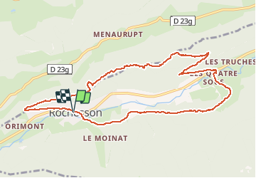
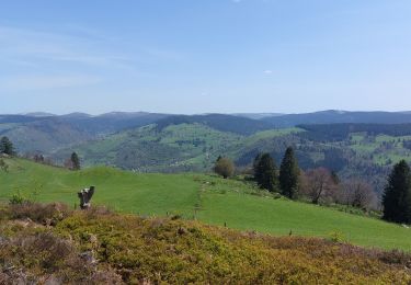
Tour Wandern von 10,6 km verfügbar auf Großer Osten, Vogesen, Rochesson. Diese Tour wird von jeanclaude12 vorgeschlagen.
Beschreibung
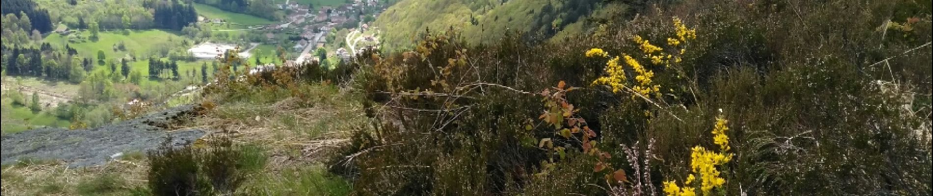
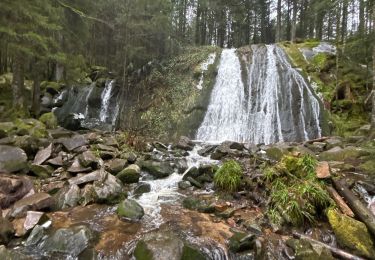
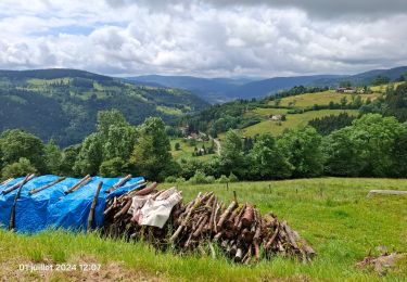
Au départ de Rochesson, voilà une agréable randonnée d'environ onze kms vers la Roche des Ducs et la Cascade du Bathion
Ort
Land:
France
Region :
Großer Osten
Abteilung/Provinz :
Vogesen
Kommune :
Rochesson
Standort:
Unknown
Gehen Sie:(Dec)
Gehen Sie:(UTM)
334858 ; 5321179 (32U) N.
Kommentare
Touren in der Umgebung
![Tour Wandern Woll - Le Couchetat - Photo](https://media.geolcdn.com/t/375/260/ext.jpg?maxdim=2&url=https%3A%2F%2Fservices.sitytrail.com%2FGeolivesWS%2FDownloadMedia.ashx%3FTrailID%3D441671%26Media%3D20150706110250.jpg)
![Wandern Wandern](https://static1.geolcdn.com/sitytour/trail-icons/101.png)
Le Couchetat
Wandern
Sehr leicht
(2)
Woll,
Großer Osten,
Vogesen,
France
![](/images/other/stat-length.png)
4,8 km | 7,4 km-effort
1h 50min
![](https://static1.geolcdn.com/siteimages/upload/files/16400158638029165_repeat_loop_refresh_sync_direction_icon.png)
Ja
![Tour Wandern Sapois - La Cascade de la Pissoire - Photo](https://media.geolcdn.com/t/375/260/ext.jpg?maxdim=2&url=https%3A%2F%2Fservices.sitytrail.com%2FGeolivesWS%2FDownloadMedia.ashx%3FTrailID%3D110286%26Media%3D5680_3.jpg)
![Wandern Wandern](https://static1.geolcdn.com/sitytour/trail-icons/101.png)
La Cascade de la Pissoire
Wandern
Medium
(2)
Sapois,
Großer Osten,
Vogesen,
France
![](/images/other/stat-length.png)
6,3 km | 8,9 km-effort
2h 0min
![](https://static1.geolcdn.com/siteimages/upload/files/16400158638029165_repeat_loop_refresh_sync_direction_icon.png)
Ja
![Tour Wandern Sapois - La Cascade de la Pissoire - Photo](https://media.geolcdn.com/t/375/260/ext.jpg?maxdim=2&url=https%3A%2F%2Fstatic1.geolcdn.com%2Fsiteimages%2Fupload%2Ffiles%2F1553511878bg_sport_marche.png)
![Wandern Wandern](https://static1.geolcdn.com/sitytour/trail-icons/101.png)
La Cascade de la Pissoire
Wandern
Einfach
(3)
Sapois,
Großer Osten,
Vogesen,
France
![](/images/other/stat-length.png)
6,3 km | 8,9 km-effort
1h 40min
![](https://static1.geolcdn.com/siteimages/upload/files/16400158638029165_repeat_loop_refresh_sync_direction_icon.png)
Ja
![Tour Reiten Gerbamont - 2022-06-05 Rando CVA Gerbamont Dommartin les Remiremont - Photo](https://media.geolcdn.com/t/375/260/fd6e9bbc-68c7-4aa5-ac35-74c2c082f858.jpg&format=jpg&maxdim=2)
![Reiten Reiten](https://static1.geolcdn.com/sitytour/trail-icons/301.png)
2022-06-05 Rando CVA Gerbamont Dommartin les Remiremont
Reiten
Schwierig
Gerbamont,
Großer Osten,
Vogesen,
France
![](/images/other/stat-length.png)
24 km | 34 km-effort
5h 10min
![](https://static1.geolcdn.com/siteimages/upload/files/16400158638029165_repeat_loop_refresh_sync_direction_icon.png)
Nein
![Tour Reiten Gerbamont - 2022-06-04 Rando CVA Gerbamont Boucle Foret de Noire Goutte - Photo](https://media.geolcdn.com/t/375/260/44bce39b-ceb9-4dae-b553-730e48ff9ece.jpg&format=jpg&maxdim=2)
![Reiten Reiten](https://static1.geolcdn.com/sitytour/trail-icons/301.png)
2022-06-04 Rando CVA Gerbamont Boucle Foret de Noire Goutte
Reiten
Sehr schwierig
Gerbamont,
Großer Osten,
Vogesen,
France
![](/images/other/stat-length.png)
31 km | 43 km-effort
6h 2min
![](https://static1.geolcdn.com/siteimages/upload/files/16400158638029165_repeat_loop_refresh_sync_direction_icon.png)
Ja
![Tour Wandern Vagney - Cascade de la Pissoire - Haut du Tôt - Photo](https://media.geolcdn.com/t/375/260/503773b0-6016-477e-af7b-2c79a373ecc2.jpg&format=jpg&maxdim=2)
![Wandern Wandern](https://static1.geolcdn.com/sitytour/trail-icons/101.png)
Cascade de la Pissoire - Haut du Tôt
Wandern
Medium
Vagney,
Großer Osten,
Vogesen,
France
![](/images/other/stat-length.png)
6,4 km | 8,8 km-effort
2h 8min
![](https://static1.geolcdn.com/siteimages/upload/files/16400158638029165_repeat_loop_refresh_sync_direction_icon.png)
Ja
![Tour Nordic Walking Basse-sur-le-Rupt - Planois - Le haut du Roc - Photo](https://media.geolcdn.com/t/375/260/af8f8d2a-d292-43d1-b86d-319eb7dfa3bc.jpg&format=jpg&maxdim=2)
![Nordic Walking Nordic Walking](https://static1.geolcdn.com/sitytour/trail-icons/102.png)
Planois - Le haut du Roc
Nordic Walking
Medium
Basse-sur-le-Rupt,
Großer Osten,
Vogesen,
France
![](/images/other/stat-length.png)
10,4 km | 17,2 km-effort
2h 28min
![](https://static1.geolcdn.com/siteimages/upload/files/16400158638029165_repeat_loop_refresh_sync_direction_icon.png)
Ja
![Tour Wandern Woll - la montagne aux Lamas - Photo](https://media.geolcdn.com/t/375/260/d17f0df7-d406-4278-bce4-bfd31c24eafd.jpg&format=jpg&maxdim=2)
![Wandern Wandern](https://static1.geolcdn.com/sitytour/trail-icons/101.png)
la montagne aux Lamas
Wandern
Einfach
Woll,
Großer Osten,
Vogesen,
France
![](/images/other/stat-length.png)
12,9 km | 18,9 km-effort
9h 19min
![](https://static1.geolcdn.com/siteimages/upload/files/16400158638029165_repeat_loop_refresh_sync_direction_icon.png)
Ja
![Tour Wandern Cornimont - Croix des Moinats - Photo](https://media.geolcdn.com/t/375/260/ca2e91a2-4aa7-4b64-a421-a0f91eabaf46.jpg&format=jpg&maxdim=2)
![Wandern Wandern](https://static1.geolcdn.com/sitytour/trail-icons/101.png)
Croix des Moinats
Wandern
Einfach
(1)
Cornimont,
Großer Osten,
Vogesen,
France
![](/images/other/stat-length.png)
5,7 km | 7,6 km-effort
1h 15min
![](https://static1.geolcdn.com/siteimages/upload/files/16400158638029165_repeat_loop_refresh_sync_direction_icon.png)
Ja