![](/images/other/stat-length.png)
![Tour Andere Aktivitäten Nantheuil - Nantheuil vers Castilloux 11km - Photo](https://media.geolcdn.com/t/1900/400/ext.pjpeg?maxdim=2&url=https%3A%2F%2Fstatic1.geolcdn.com%2Fsiteimages%2Fupload%2Ffiles%2F1545311037marcheuse_200dpi.jpg)
Nantheuil vers Castilloux 11km
YV24
Benutzer
![Länge](/images/other/stat-length.png)
Länge
11 km
![Maximale Höhe](https://static1.geolcdn.com/siteimages/upload/files/1508320355ic_sort_altitude_max_24dp.png)
Maximale Höhe
268 m
![Positive Höhendifferenz](https://static1.geolcdn.com/siteimages/upload/files/1508320355ic_sort_den_pos_24dp.png)
Positive Höhendifferenz
234 m
![Km-Effort](/images/other/stat-length.png)
Km-Effort
14,2 km
![Min. Höhe](https://static1.geolcdn.com/siteimages/upload/files/1508320355ic_sort_altitude_min_24dp.png)
Min. Höhe
159 m
![Negative Höhendifferenz](https://static1.geolcdn.com/siteimages/upload/files/1508320355ic_sort_den_neg_24dp.png)
Negative Höhendifferenz
233 m
![Boucle](https://static1.geolcdn.com/siteimages/upload/files/16400158638029165_repeat_loop_refresh_sync_direction_icon.png)
Boucle
Ja
Erstellungsdatum :
2017-03-29 00:00:00.0
Letzte Änderung :
2022-01-31 17:09:03.529
![Andere Aktivitäten](https://static1.geolcdn.com/sitytour/trail-icons/900.png)
2h47
Schwierigkeit : Unbekannt
![Scannen Sie diesen QR-Code, um die Tour in der SityTrail-Anwendung zu öffnen](https://capi.geolives.com/qq0zvz2zws4bq2lad0pu/sitytour/trails/721939/qr.png?size=200)
Kostenlosegpshiking-Anwendung
Über SityTrail
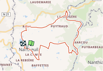
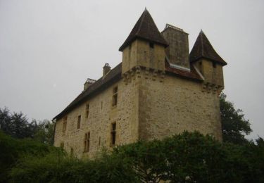
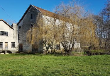
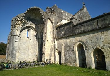
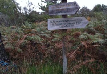
Tour Andere Aktivitäten von 11 km verfügbar auf Neu-Aquitanien, Dordogne, Nantheuil. Diese Tour wird von YV24 vorgeschlagen.
Beschreibung
Boucle spéciale, selon PDIPR n°5 carto Thiviers et liaison verte.
Variée, vallonnée, peu de route,ornières possible après fortes pluies.
Ort
Land:
France
Region :
Neu-Aquitanien
Abteilung/Provinz :
Dordogne
Kommune :
Nantheuil
Standort:
Unknown
Gehen Sie:(Dec)
Gehen Sie:(UTM)
339153 ; 5030929 (31T) N.
Kommentare
Touren in der Umgebung
![Tour Wandern Saint-Sulpice-d'Excideuil - Les boucles la Caraque/le Ravillou - Saint-Sulpice-d'Excideuil - Photo](https://media.geolcdn.com/t/375/260/ext.jpg?maxdim=2&url=https%3A%2F%2Fservices.sitytrail.com%2FGeolivesWS%2FDownloadMedia.ashx%3FTrailID%3D112559%26Media%3D10867_6.jpg)
![Wandern Wandern](https://static1.geolcdn.com/sitytour/trail-icons/101.png)
Les boucles la Caraque/le Ravillou - Saint-Sulpice-d'Excideuil
Wandern
Medium
(1)
Saint-Sulpice-d'Excideuil,
Neu-Aquitanien,
Dordogne,
France
![](/images/other/stat-length.png)
7,7 km | 10 km-effort
2h 0min
![](https://static1.geolcdn.com/siteimages/upload/files/16400158638029165_repeat_loop_refresh_sync_direction_icon.png)
Ja
![Tour Wandern Corgnac-sur-l'Isle - Boucle de Puyfebert à Corgnac sur L'isle (24) - Photo](https://media.geolcdn.com/t/375/260/473ca2ea-b417-4ef5-b016-acee12c3b097.jpg&format=jpg&maxdim=2)
![Wandern Wandern](https://static1.geolcdn.com/sitytour/trail-icons/101.png)
Boucle de Puyfebert à Corgnac sur L'isle (24)
Wandern
Sehr leicht
(1)
Corgnac-sur-l'Isle,
Neu-Aquitanien,
Dordogne,
France
![](/images/other/stat-length.png)
13,4 km | 16,5 km-effort
3h 27min
![](https://static1.geolcdn.com/siteimages/upload/files/16400158638029165_repeat_loop_refresh_sync_direction_icon.png)
Ja
![Tour Wandern Saint-Sulpice-d'Excideuil - St Sulpice Excideuil Cavaire + Ravillou 12km - Photo](https://media.geolcdn.com/t/375/260/ext.jpg?maxdim=2&url=https%3A%2F%2Fstatic1.geolcdn.com%2Fsiteimages%2Fupload%2Ffiles%2F1553511878bg_sport_marche.png)
![Wandern Wandern](https://static1.geolcdn.com/sitytour/trail-icons/101.png)
St Sulpice Excideuil Cavaire + Ravillou 12km
Wandern
Einfach
(1)
Saint-Sulpice-d'Excideuil,
Neu-Aquitanien,
Dordogne,
France
![](/images/other/stat-length.png)
11,3 km | 14,4 km-effort
3h 5min
![](https://static1.geolcdn.com/siteimages/upload/files/16400158638029165_repeat_loop_refresh_sync_direction_icon.png)
Ja
![Tour Mountainbike Thiviers - Thiviers vtt - Photo](https://media.geolcdn.com/t/375/260/df34d907-768b-4b26-a7b5-5ec7cdc86a99.jpg&format=jpg&maxdim=2)
![Mountainbike Mountainbike](https://static1.geolcdn.com/sitytour/trail-icons/202.png)
Thiviers vtt
Mountainbike
Sehr leicht
Thiviers,
Neu-Aquitanien,
Dordogne,
France
![](/images/other/stat-length.png)
48 km | 58 km-effort
6h 2min
![](https://static1.geolcdn.com/siteimages/upload/files/16400158638029165_repeat_loop_refresh_sync_direction_icon.png)
Ja
![Tour Wandern Eyzerac - La Servolle 2 - Photo](https://media.geolcdn.com/t/375/260/ext.jpg?maxdim=2&url=https%3A%2F%2Fservices.sitytrail.com%2FGeolivesWS%2FDownloadMedia.ashx%3FTrailID%3D226050%26Media%3D20131008110344.jpg)
![Wandern Wandern](https://static1.geolcdn.com/sitytour/trail-icons/101.png)
La Servolle 2
Wandern
Einfach
Eyzerac,
Neu-Aquitanien,
Dordogne,
France
![](/images/other/stat-length.png)
12,4 km | 14,9 km-effort
3h 16min
![](https://static1.geolcdn.com/siteimages/upload/files/16400158638029165_repeat_loop_refresh_sync_direction_icon.png)
Ja
![Tour Wandern Nantheuil - Nantheuil route - Photo](https://media.geolcdn.com/t/375/260/ext.jpg?maxdim=2&url=https%3A%2F%2Fstatic1.geolcdn.com%2Fsiteimages%2Fupload%2Ffiles%2F1553511878bg_sport_marche.png)
![Wandern Wandern](https://static1.geolcdn.com/sitytour/trail-icons/101.png)
Nantheuil route
Wandern
Einfach
Nantheuil,
Neu-Aquitanien,
Dordogne,
France
![](/images/other/stat-length.png)
8 km | 9,6 km-effort
1h 39min
![](https://static1.geolcdn.com/siteimages/upload/files/16400158638029165_repeat_loop_refresh_sync_direction_icon.png)
Nein
![Tour Wandern Nantheuil - Boucle observatoire allongée Nantheuil - Photo](https://media.geolcdn.com/t/375/260/efe1fbe8-4080-47ca-9be9-dfb6227d2dee.jpg&format=jpg&maxdim=2)
![Wandern Wandern](https://static1.geolcdn.com/sitytour/trail-icons/101.png)
Boucle observatoire allongée Nantheuil
Wandern
Medium
Nantheuil,
Neu-Aquitanien,
Dordogne,
France
![](/images/other/stat-length.png)
11,2 km | 14,2 km-effort
2h 52min
![](https://static1.geolcdn.com/siteimages/upload/files/16400158638029165_repeat_loop_refresh_sync_direction_icon.png)
Ja
![Tour Wandern Eyzerac - Eyzerat - Photo](https://media.geolcdn.com/t/375/260/ext.jpg?maxdim=2&url=https%3A%2F%2Fstatic1.geolcdn.com%2Fsiteimages%2Fupload%2Ffiles%2F1553511878bg_sport_marche.png)
![Wandern Wandern](https://static1.geolcdn.com/sitytour/trail-icons/101.png)
Eyzerat
Wandern
Medium
Eyzerac,
Neu-Aquitanien,
Dordogne,
France
![](/images/other/stat-length.png)
12,8 km | 15,7 km-effort
3h 3min
![](https://static1.geolcdn.com/siteimages/upload/files/16400158638029165_repeat_loop_refresh_sync_direction_icon.png)
Ja
![Tour Wandern Sarrazac - tacot de Nantheuil - Photo](https://media.geolcdn.com/t/375/260/ext.jpg?maxdim=2&url=https%3A%2F%2Fstatic1.geolcdn.com%2Fsiteimages%2Fupload%2Ffiles%2F1553511878bg_sport_marche.png)
![Wandern Wandern](https://static1.geolcdn.com/sitytour/trail-icons/101.png)
tacot de Nantheuil
Wandern
Sehr leicht
Sarrazac,
Neu-Aquitanien,
Dordogne,
France
![](/images/other/stat-length.png)
7,2 km | 8,5 km-effort
1h 21min
![](https://static1.geolcdn.com/siteimages/upload/files/16400158638029165_repeat_loop_refresh_sync_direction_icon.png)
Ja