![](/images/other/stat-length.png)
![Tour Schneeschuhwandern Lans-en-Vercors - La Moucherotte - Photo](https://media.geolcdn.com/t/1900/400/ext.pjpeg?maxdim=2&url=https%3A%2F%2Fstatic1.geolcdn.com%2Fsiteimages%2Fupload%2Ffiles%2F1524743153raquette.jpg)
La Moucherotte
ARPF
Benutzer
![Länge](/images/other/stat-length.png)
Länge
12,4 km
![Maximale Höhe](https://static1.geolcdn.com/siteimages/upload/files/1508320355ic_sort_altitude_max_24dp.png)
Maximale Höhe
1885 m
![Positive Höhendifferenz](https://static1.geolcdn.com/siteimages/upload/files/1508320355ic_sort_den_pos_24dp.png)
Positive Höhendifferenz
509 m
![Km-Effort](/images/other/stat-length.png)
Km-Effort
19,2 km
![Min. Höhe](https://static1.geolcdn.com/siteimages/upload/files/1508320355ic_sort_altitude_min_24dp.png)
Min. Höhe
1372 m
![Negative Höhendifferenz](https://static1.geolcdn.com/siteimages/upload/files/1508320355ic_sort_den_neg_24dp.png)
Negative Höhendifferenz
510 m
![Boucle](https://static1.geolcdn.com/siteimages/upload/files/16400158638029165_repeat_loop_refresh_sync_direction_icon.png)
Boucle
Ja
Erstellungsdatum :
2018-01-12 00:00:00.0
Letzte Änderung :
2018-01-12 00:00:00.0
![Schneeschuhwandern](https://static1.geolcdn.com/sitytour/trail-icons/504.png)
5h51
Schwierigkeit : Schwierig
![Scannen Sie diesen QR-Code, um die Tour in der SityTrail-Anwendung zu öffnen](https://capi.geolives.com/qq0zvz2zws4bq2lad0pu/sitytour/trails/721873/qr.png?size=200)
Kostenlosegpshiking-Anwendung
Über SityTrail
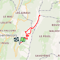
Tour Schneeschuhwandern von 12,4 km verfügbar auf Auvergne-Rhone-Alpen, Isère, Lans-en-Vercors. Diese Tour wird von ARPF vorgeschlagen.
Beschreibung
P2 T2 fait en 2017
Très belle rando sur la crête de la Grande Roche St Michel avec vue exceptionnelle sur Grenoble.
Pourrait être raccourcie en cas de difficulté.
PhG
Ort
Land:
France
Region :
Auvergne-Rhone-Alpen
Abteilung/Provinz :
Isère
Kommune :
Lans-en-Vercors
Standort:
Unknown
Gehen Sie:(Dec)
Gehen Sie:(UTM)
705303 ; 4999351 (31T) N.
Kommentare
Touren in der Umgebung
![Tour Nordic Walking Seyssins - Seyssins le haut - Les Arcelles dans la neige - Photo](https://media.geolcdn.com/t/375/260/09832c62-e152-4e15-aea9-389ff5328b66.jpg&format=jpg&maxdim=2)
![Nordic Walking Nordic Walking](https://static1.geolcdn.com/sitytour/trail-icons/102.png)
Seyssins le haut - Les Arcelles dans la neige
Nordic Walking
Medium
(1)
Seyssins,
Auvergne-Rhone-Alpen,
Isère,
France
![](/images/other/stat-length.png)
9,1 km | 13,8 km-effort
2h 45min
![](https://static1.geolcdn.com/siteimages/upload/files/16400158638029165_repeat_loop_refresh_sync_direction_icon.png)
Ja
![Tour Wandern Seyssins - MOUCHEROTTE - Photo](https://media.geolcdn.com/t/375/260/fbc259ea-06fa-4a05-83ef-656dc650e275.jpg&format=jpg&maxdim=2)
![Wandern Wandern](https://static1.geolcdn.com/sitytour/trail-icons/101.png)
MOUCHEROTTE
Wandern
Schwierig
(1)
Seyssins,
Auvergne-Rhone-Alpen,
Isère,
France
![](/images/other/stat-length.png)
20 km | 40 km-effort
8h 9min
![](https://static1.geolcdn.com/siteimages/upload/files/16400158638029165_repeat_loop_refresh_sync_direction_icon.png)
Ja
![Tour Wandern Lans-en-Vercors - 38 pic st michel - Photo](https://media.geolcdn.com/t/375/260/cfeb7787-6d5b-45db-91c6-1feb93d2f73c.jpg&format=jpg&maxdim=2)
![Wandern Wandern](https://static1.geolcdn.com/sitytour/trail-icons/101.png)
38 pic st michel
Wandern
Einfach
(1)
Lans-en-Vercors,
Auvergne-Rhone-Alpen,
Isère,
France
![](/images/other/stat-length.png)
8,7 km | 17,3 km-effort
5h 16min
![](https://static1.geolcdn.com/siteimages/upload/files/16400158638029165_repeat_loop_refresh_sync_direction_icon.png)
Ja
![Tour Schneeschuhwandern Lans-en-Vercors - La Crête des Ramées de nuit en raquettes - Photo](https://media.geolcdn.com/t/375/260/ext.jpg?maxdim=2&url=https%3A%2F%2Fservices.sitytrail.com%2FGeolivesWS%2FDownloadMedia.ashx%3FTrailID%3D897155%26Media%3Dfix__20180130203527.jpg)
![Schneeschuhwandern Schneeschuhwandern](https://static1.geolcdn.com/sitytour/trail-icons/504.png)
La Crête des Ramées de nuit en raquettes
Schneeschuhwandern
Medium
(1)
Lans-en-Vercors,
Auvergne-Rhone-Alpen,
Isère,
France
![](/images/other/stat-length.png)
8 km | 13,4 km-effort
4h 9min
![](https://static1.geolcdn.com/siteimages/upload/files/16400158638029165_repeat_loop_refresh_sync_direction_icon.png)
Ja
![Tour Wandern Lans-en-Vercors - Le Pic saint michel - Photo](https://media.geolcdn.com/t/375/260/ext.jpg?maxdim=2&url=https%3A%2F%2Fservices.sitytrail.com%2FGeolivesWS%2FDownloadMedia.ashx%3FTrailID%3D205024%26Media%3Dfix__20130714151209.jpg)
![Wandern Wandern](https://static1.geolcdn.com/sitytour/trail-icons/101.png)
Le Pic saint michel
Wandern
Einfach
(1)
Lans-en-Vercors,
Auvergne-Rhone-Alpen,
Isère,
France
![](/images/other/stat-length.png)
6,5 km | 13,2 km-effort
2h 38min
![](https://static1.geolcdn.com/siteimages/upload/files/16400158638029165_repeat_loop_refresh_sync_direction_icon.png)
Nein
![Tour Wandern Lans-en-Vercors - le vertige des cimes - Photo](https://media.geolcdn.com/t/375/260/2d2e8455-1754-4db8-b9ed-75845d14fe6a.jpg&format=jpg&maxdim=2)
![Wandern Wandern](https://static1.geolcdn.com/sitytour/trail-icons/101.png)
le vertige des cimes
Wandern
Medium
(1)
Lans-en-Vercors,
Auvergne-Rhone-Alpen,
Isère,
France
![](/images/other/stat-length.png)
6,3 km | 11 km-effort
2h 9min
![](https://static1.geolcdn.com/siteimages/upload/files/16400158638029165_repeat_loop_refresh_sync_direction_icon.png)
Ja
![Tour Wandern Lans-en-Vercors - Lans - Belvédère Vertige des Cimes depuis Le Furon - Photo](https://media.geolcdn.com/t/375/260/ext.jpg?maxdim=2&url=https%3A%2F%2Fservices.sitytrail.com%2FGeolivesWS%2FDownloadMedia.ashx%3FTrailID%3D661434%26Media%3Dfix__20161117114034.jpg)
![Wandern Wandern](https://static1.geolcdn.com/sitytour/trail-icons/101.png)
Lans - Belvédère Vertige des Cimes depuis Le Furon
Wandern
Medium
(1)
Lans-en-Vercors,
Auvergne-Rhone-Alpen,
Isère,
France
![](/images/other/stat-length.png)
8 km | 15,9 km-effort
3h 9min
![](https://static1.geolcdn.com/siteimages/upload/files/16400158638029165_repeat_loop_refresh_sync_direction_icon.png)
Ja
![Tour Schneeschuhwandern Lans-en-Vercors - Le Pic Saint-Michel en raquettes (2012) - Photo](https://media.geolcdn.com/t/375/260/ext.jpg?maxdim=2&url=https%3A%2F%2Fservices.sitytrail.com%2FGeolivesWS%2FDownloadMedia.ashx%3FTrailID%3D107676%26Media%3D12680_1.jpg)
![Schneeschuhwandern Schneeschuhwandern](https://static1.geolcdn.com/sitytour/trail-icons/504.png)
Le Pic Saint-Michel en raquettes (2012)
Schneeschuhwandern
Medium
(2)
Lans-en-Vercors,
Auvergne-Rhone-Alpen,
Isère,
France
![](/images/other/stat-length.png)
8,4 km | 17,3 km-effort
5h 0min
![](https://static1.geolcdn.com/siteimages/upload/files/16400158638029165_repeat_loop_refresh_sync_direction_icon.png)
Ja
![Tour Wandern Lans-en-Vercors - La Grande Roche Saint-Michel, depuis Furon - Photo](https://media.geolcdn.com/t/375/260/ext.jpg?maxdim=2&url=https%3A%2F%2Fservices.sitytrail.com%2FGeolivesWS%2FDownloadMedia.ashx%3FTrailID%3D103768%26Media%3D6521_1.jpg)
![Wandern Wandern](https://static1.geolcdn.com/sitytour/trail-icons/101.png)
La Grande Roche Saint-Michel, depuis Furon
Wandern
Einfach
(1)
Lans-en-Vercors,
Auvergne-Rhone-Alpen,
Isère,
France
![](/images/other/stat-length.png)
8,4 km | 17,1 km-effort
4h 0min
![](https://static1.geolcdn.com/siteimages/upload/files/16400158638029165_repeat_loop_refresh_sync_direction_icon.png)
Ja