![](/images/other/stat-length.png)
![Tour Wandern Torsac - Torsac. Sentier des croix - Photo](https://media.geolcdn.com/t/1900/400/ext.pjpeg?maxdim=2&url=https%3A%2F%2Fservices.sitytrail.com%2FGeolivesWS%2FDownloadMedia.ashx%3FTrailID%3D721633%26Media%3D20170327162429.jpg)
Torsac. Sentier des croix
dorcier
Benutzer
![Länge](/images/other/stat-length.png)
Länge
10,1 km
![Maximale Höhe](https://static1.geolcdn.com/siteimages/upload/files/1508320355ic_sort_altitude_max_24dp.png)
Maximale Höhe
157 m
![Positive Höhendifferenz](https://static1.geolcdn.com/siteimages/upload/files/1508320355ic_sort_den_pos_24dp.png)
Positive Höhendifferenz
138 m
![Km-Effort](/images/other/stat-length.png)
Km-Effort
11,9 km
![Min. Höhe](https://static1.geolcdn.com/siteimages/upload/files/1508320355ic_sort_altitude_min_24dp.png)
Min. Höhe
101 m
![Negative Höhendifferenz](https://static1.geolcdn.com/siteimages/upload/files/1508320355ic_sort_den_neg_24dp.png)
Negative Höhendifferenz
133 m
![Boucle](https://static1.geolcdn.com/siteimages/upload/files/16400158638029165_repeat_loop_refresh_sync_direction_icon.png)
Boucle
Ja
Erstellungsdatum :
2017-03-28 00:00:00.0
Letzte Änderung :
2017-03-28 00:00:00.0
![Wandern](https://static1.geolcdn.com/sitytour/trail-icons/101.png)
2h37
Schwierigkeit : Einfach
![Scannen Sie diesen QR-Code, um die Tour in der SityTrail-Anwendung zu öffnen](https://capi.geolives.com/qq0zvz2zws4bq2lad0pu/sitytour/trails/721633/qr.png?size=200)
Kostenlosegpshiking-Anwendung
Über SityTrail
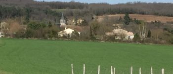
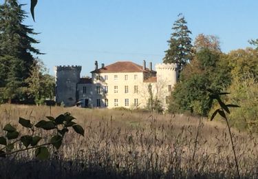
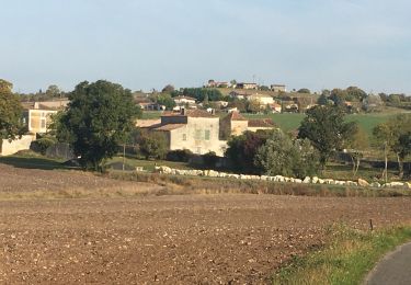
Tour Wandern von 10,1 km verfügbar auf Neu-Aquitanien, Charente, Torsac. Diese Tour wird von dorcier vorgeschlagen.
Beschreibung
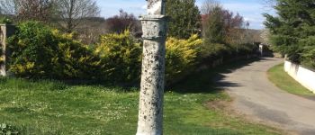
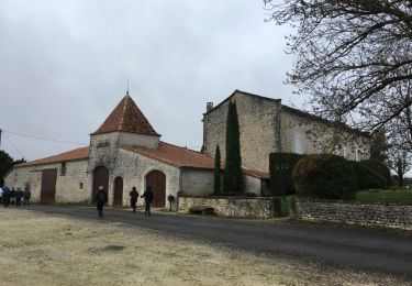
Départ parking face au cimetière sur la D41.
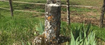
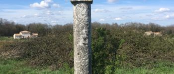
Le nom du cimetière est dû aux cinq croix qui le jalonnent. Elles évoquent la chrétienté mais servaient aussi de repères pour les différentes propriétés ou limites de communes.
Ort
Land:
France
Region :
Neu-Aquitanien
Abteilung/Provinz :
Charente
Kommune :
Torsac
Standort:
Unknown
Gehen Sie:(Dec)
Gehen Sie:(UTM)
282633 ; 5049364 (31T) N.
Kommentare
Touren in der Umgebung
![Tour Wandern Dirac - Les lavoirs de Dirac - Photo](https://media.geolcdn.com/t/375/260/ext.jpg?maxdim=2&url=https%3A%2F%2Fservices.sitytrail.com%2FGeolivesWS%2FDownloadMedia.ashx%3FTrailID%3D652918%26Media%3D20161027155143.jpg)
![Wandern Wandern](https://static1.geolcdn.com/sitytour/trail-icons/101.png)
Les lavoirs de Dirac
Wandern
Einfach
Dirac,
Neu-Aquitanien,
Charente,
France
![](/images/other/stat-length.png)
7,4 km | 9 km-effort
2h 5min
![](https://static1.geolcdn.com/siteimages/upload/files/16400158638029165_repeat_loop_refresh_sync_direction_icon.png)
Ja
![Tour Wandern Fouquebrune - Fouquebrune (rando de la Motte) - Photo](https://media.geolcdn.com/t/375/260/8beecb7b-08af-49b1-96b9-ce1975c9c8ad.jpg&format=jpg&maxdim=2)
![Wandern Wandern](https://static1.geolcdn.com/sitytour/trail-icons/101.png)
Fouquebrune (rando de la Motte)
Wandern
Einfach
Fouquebrune,
Neu-Aquitanien,
Charente,
France
![](/images/other/stat-length.png)
9,9 km | 11,5 km-effort
2h 5min
![](https://static1.geolcdn.com/siteimages/upload/files/16400158638029165_repeat_loop_refresh_sync_direction_icon.png)
Ja
![Tour Wandern Fouquebrune - fouquebrune - Photo](https://media.geolcdn.com/t/375/260/ext.jpg?maxdim=2&url=https%3A%2F%2Fservices.sitytrail.com%2FGeolivesWS%2FDownloadMedia.ashx%3FTrailID%3D1088304%26Media%3D20181206144824.jpg)
![Wandern Wandern](https://static1.geolcdn.com/sitytour/trail-icons/101.png)
fouquebrune
Wandern
Sehr leicht
Fouquebrune,
Neu-Aquitanien,
Charente,
France
![](/images/other/stat-length.png)
8,7 km | 9,9 km-effort
2h 14min
![](https://static1.geolcdn.com/siteimages/upload/files/16400158638029165_repeat_loop_refresh_sync_direction_icon.png)
Ja
![Tour Wandern Puymoyen - La vallée des Eaux claires - Photo](https://media.geolcdn.com/t/375/260/ext.jpg?maxdim=2&url=https%3A%2F%2Fservices.sitytrail.com%2FGeolivesWS%2FDownloadMedia.ashx%3FTrailID%3D533119%26Media%3Dfix__20160303145154.jpg)
![Wandern Wandern](https://static1.geolcdn.com/sitytour/trail-icons/101.png)
La vallée des Eaux claires
Wandern
Einfach
Puymoyen,
Neu-Aquitanien,
Charente,
France
![](/images/other/stat-length.png)
9,2 km | 11,1 km-effort
2h 36min
![](https://static1.geolcdn.com/siteimages/upload/files/16400158638029165_repeat_loop_refresh_sync_direction_icon.png)
Ja
![Tour Wandern Dignac - dignac_ouest G-16417318 - Photo](https://media.geolcdn.com/t/375/260/ext.jpg?maxdim=2&url=https%3A%2F%2Fstatic1.geolcdn.com%2Fsiteimages%2Fupload%2Ffiles%2F1553511878bg_sport_marche.png)
![Wandern Wandern](https://static1.geolcdn.com/sitytour/trail-icons/101.png)
dignac_ouest G-16417318
Wandern
Schwierig
Dignac,
Neu-Aquitanien,
Charente,
France
![](/images/other/stat-length.png)
11,3 km | 13,4 km-effort
3h 2min
![](https://static1.geolcdn.com/siteimages/upload/files/16400158638029165_repeat_loop_refresh_sync_direction_icon.png)
Ja
![Tour Wandern Dirac - Dirac - Photo](https://media.geolcdn.com/t/375/260/ext.jpg?maxdim=2&url=https%3A%2F%2Fstatic1.geolcdn.com%2Fsiteimages%2Fupload%2Ffiles%2F1553511878bg_sport_marche.png)
![Wandern Wandern](https://static1.geolcdn.com/sitytour/trail-icons/101.png)
![Tour Pfad Torsac - torsac - Photo](https://media.geolcdn.com/t/375/260/1bbe6254-9235-45f0-9ffa-2ff4eafef78e.jpg&format=jpg&maxdim=2)
![Pfad Pfad](https://static1.geolcdn.com/sitytour/trail-icons/104.png)
![Tour Mountainbike Dirac - VTT DIRAC 16 - Photo](https://media.geolcdn.com/t/375/260/ext.jpg?maxdim=2&url=https%3A%2F%2Fstatic1.geolcdn.com%2Fsiteimages%2Fupload%2Ffiles%2F1524743154velo.jpg)
![Mountainbike Mountainbike](https://static1.geolcdn.com/sitytour/trail-icons/202.png)
VTT DIRAC 16
Mountainbike
Schwierig
Dirac,
Neu-Aquitanien,
Charente,
France
![](/images/other/stat-length.png)
48 km | 60 km-effort
Unbekannt
![](https://static1.geolcdn.com/siteimages/upload/files/16400158638029165_repeat_loop_refresh_sync_direction_icon.png)
Ja
![Tour Wandern Fouquebrune - fouquebrune - Photo](https://media.geolcdn.com/t/375/260/ext.jpg?maxdim=2&url=https%3A%2F%2Fstatic1.geolcdn.com%2Fsiteimages%2Fupload%2Ffiles%2F1553511878bg_sport_marche.png)
![Wandern Wandern](https://static1.geolcdn.com/sitytour/trail-icons/101.png)
fouquebrune
Wandern
Sehr leicht
Fouquebrune,
Neu-Aquitanien,
Charente,
France
![](/images/other/stat-length.png)
17,4 km | 20 km-effort
4h 15min
![](https://static1.geolcdn.com/siteimages/upload/files/16400158638029165_repeat_loop_refresh_sync_direction_icon.png)
Ja