![](/images/other/stat-length.png)
![Tour Wandern Saint-Hubert - Entre Lesse et Lomme_14-L-Libin - Photo](https://media.geolcdn.com/t/1900/400/cd2e11b0-ff3c-4f35-ac64-68cef0667ebc.jpg&format=pjpeg&maxdim=2)
Entre Lesse et Lomme_14-L-Libin
La Grande Forêt de Saint-Hubert
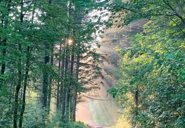
Randonnées de la Grande Forêt de Saint-Hubert GUIDE+
![Länge](/images/other/stat-length.png)
Länge
4,6 km
![Maximale Höhe](https://static1.geolcdn.com/siteimages/upload/files/1508320355ic_sort_altitude_max_24dp.png)
Maximale Höhe
470 m
![Positive Höhendifferenz](https://static1.geolcdn.com/siteimages/upload/files/1508320355ic_sort_den_pos_24dp.png)
Positive Höhendifferenz
90 m
![Km-Effort](/images/other/stat-length.png)
Km-Effort
5,7 km
![Min. Höhe](https://static1.geolcdn.com/siteimages/upload/files/1508320355ic_sort_altitude_min_24dp.png)
Min. Höhe
381 m
![Negative Höhendifferenz](https://static1.geolcdn.com/siteimages/upload/files/1508320355ic_sort_den_neg_24dp.png)
Negative Höhendifferenz
73 m
![Boucle](https://static1.geolcdn.com/siteimages/upload/files/16400158638029165_repeat_loop_refresh_sync_direction_icon.png)
Boucle
Nein
Erstellungsdatum :
2018-05-07 00:00:00.0
Letzte Änderung :
2020-04-24 08:32:42.904
![Wandern](https://static1.geolcdn.com/sitytour/trail-icons/101.png)
1h15
Schwierigkeit : Unbekannt
![Scannen Sie diesen QR-Code, um die Tour in der SityTrail-Anwendung zu öffnen](https://capi.geolives.com/qq0zvz2zws4bq2lad0pu/sitytour/trails/717304/qr.png?size=200)
Kostenlosegpshiking-Anwendung
Über SityTrail
Tour Wandern von 4,6 km verfügbar auf Wallonien, Luxemburg, Saint-Hubert. Diese Tour wird von La Grande Forêt de Saint-Hubert vorgeschlagen.
Beschreibung
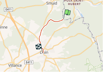
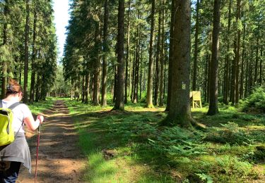
Ce parcours permet de relier le parcours "Entre Lesse et Lomme", du point 14-L-Randour-Vicinal" au village de Libin.
Ort
Land:
Belgium
Region :
Wallonien
Abteilung/Provinz :
Luxemburg
Kommune :
Saint-Hubert
Standort:
Libin
Gehen Sie:(Dec)
Gehen Sie:(UTM)
663400 ; 5541850 (31U) N.
Kommentare
Touren in der Umgebung
![Tour Wandern Saint-Hubert - Hatrival - Banalbois (SH13) - Photo](https://media.geolcdn.com/t/375/260/ext.jpg?maxdim=2&url=https%3A%2F%2Fservices.sitytrail.com%2FGeolivesWS%2FDownloadMedia.ashx%3FTrailID%3D334467%26Media%3D16828998-416a-43a0-960f-95ce479e5d6d.jpg)
![Wandern Wandern](https://static1.geolcdn.com/sitytour/trail-icons/101.png)
Hatrival - Banalbois (SH13)
Wandern
Medium
(6)
Saint-Hubert,
Wallonien,
Luxemburg,
Belgium
![](/images/other/stat-length.png)
7,5 km | 9,5 km-effort
2h 2min
![](https://static1.geolcdn.com/siteimages/upload/files/16400158638029165_repeat_loop_refresh_sync_direction_icon.png)
Ja
![Tour Wandern Saint-Hubert - Poix - Sainte-Adeline (SH15) - Photo](https://media.geolcdn.com/t/375/260/ext.jpg?maxdim=2&url=https%3A%2F%2Fservices.sitytrail.com%2FGeolivesWS%2FDownloadMedia.ashx%3FTrailID%3D334489%26Media%3Dff5c6d1c-0697-4565-9157-6580a8b8d275.jpg)
![Wandern Wandern](https://static1.geolcdn.com/sitytour/trail-icons/101.png)
Poix - Sainte-Adeline (SH15)
Wandern
Medium
(7)
Saint-Hubert,
Wallonien,
Luxemburg,
Belgium
![](/images/other/stat-length.png)
8,3 km | 10,8 km-effort
2h 23min
![](https://static1.geolcdn.com/siteimages/upload/files/16400158638029165_repeat_loop_refresh_sync_direction_icon.png)
Ja
![Tour Wandern Saint-Hubert - Marche ADEPS Arville - Photo](https://media.geolcdn.com/t/375/260/3bbd3001-2495-4fe0-a9c1-b38774f0038e.jpg&format=jpg&maxdim=2)
![Wandern Wandern](https://static1.geolcdn.com/sitytour/trail-icons/101.png)
Marche ADEPS Arville
Wandern
Medium
(1)
Saint-Hubert,
Wallonien,
Luxemburg,
Belgium
![](/images/other/stat-length.png)
10,2 km | 13,6 km-effort
2h 13min
![](https://static1.geolcdn.com/siteimages/upload/files/16400158638029165_repeat_loop_refresh_sync_direction_icon.png)
Ja
![Tour Mountainbike Saint-Hubert - Poix - La Lhomme (VTT SH06) - Photo](https://media.geolcdn.com/t/375/260/ext.jpg?maxdim=2&url=https%3A%2F%2Fservices.sitytrail.com%2FGeolivesWS%2FDownloadMedia.ashx%3FTrailID%3D334556%26Media%3Da91ea124-054e-449d-9773-8d26e176c2fd.jpg)
![Mountainbike Mountainbike](https://static1.geolcdn.com/sitytour/trail-icons/202.png)
Poix - La Lhomme (VTT SH06)
Mountainbike
Medium
(4)
Saint-Hubert,
Wallonien,
Luxemburg,
Belgium
![](/images/other/stat-length.png)
24 km | 31 km-effort
2h 1min
![](https://static1.geolcdn.com/siteimages/upload/files/16400158638029165_repeat_loop_refresh_sync_direction_icon.png)
Ja
![Tour Wandern Libin - Libin par dessus - Photo](https://media.geolcdn.com/t/375/260/abf79579-5895-454e-ada2-cb9d595cfe0c.jpg&format=jpg&maxdim=2)
![Wandern Wandern](https://static1.geolcdn.com/sitytour/trail-icons/101.png)
Libin par dessus
Wandern
Einfach
(3)
Libin,
Wallonien,
Luxemburg,
Belgium
![](/images/other/stat-length.png)
8,2 km | 10 km-effort
1h 45min
![](https://static1.geolcdn.com/siteimages/upload/files/16400158638029165_repeat_loop_refresh_sync_direction_icon.png)
Ja
![Tour Wandern Libin - Transinne - Les Voies d'Antan (LI12) - Photo](https://media.geolcdn.com/t/375/260/9c2533c3-01b6-4ea6-863f-eedbbedfdc39.jpg&format=jpg&maxdim=2)
![Wandern Wandern](https://static1.geolcdn.com/sitytour/trail-icons/101.png)
Transinne - Les Voies d'Antan (LI12)
Wandern
Medium
(1)
Libin,
Wallonien,
Luxemburg,
Belgium
![](/images/other/stat-length.png)
10 km | 12,5 km-effort
2h 44min
![](https://static1.geolcdn.com/siteimages/upload/files/16400158638029165_repeat_loop_refresh_sync_direction_icon.png)
Ja
![Tour Wandern Libin - Villance - Promenade des Ponts (LI14) - Photo](https://media.geolcdn.com/t/375/260/fe9fccf1-9bca-4e04-ac67-5acf6a5bba21.jpg&format=jpg&maxdim=2)
![Wandern Wandern](https://static1.geolcdn.com/sitytour/trail-icons/101.png)
Villance - Promenade des Ponts (LI14)
Wandern
Einfach
(4)
Libin,
Wallonien,
Luxemburg,
Belgium
![](/images/other/stat-length.png)
8,1 km | 9,7 km-effort
2h 8min
![](https://static1.geolcdn.com/siteimages/upload/files/16400158638029165_repeat_loop_refresh_sync_direction_icon.png)
Ja
![Tour Wandern Libin - Smuid - Promenade du bois de Renimont - Photo](https://media.geolcdn.com/t/375/260/797a85ad-6b8a-4d5d-804f-0c47f97e93d7.jpg&format=jpg&maxdim=2)
![Wandern Wandern](https://static1.geolcdn.com/sitytour/trail-icons/101.png)
Smuid - Promenade du bois de Renimont
Wandern
Einfach
(1)
Libin,
Wallonien,
Luxemburg,
Belgium
![](/images/other/stat-length.png)
10,2 km | 13,4 km-effort
2h 56min
![](https://static1.geolcdn.com/siteimages/upload/files/16400158638029165_repeat_loop_refresh_sync_direction_icon.png)
Ja
![Tour Wandern Libin - Smuid - Promenade de Smuid - Photo](https://media.geolcdn.com/t/375/260/4927d3fd-64d5-402b-b051-09b0154a8357.jpg&format=jpg&maxdim=2)
![Wandern Wandern](https://static1.geolcdn.com/sitytour/trail-icons/101.png)
Smuid - Promenade de Smuid
Wandern
Medium
(3)
Libin,
Wallonien,
Luxemburg,
Belgium
![](/images/other/stat-length.png)
4,9 km | 6,4 km-effort
1h 27min
![](https://static1.geolcdn.com/siteimages/upload/files/16400158638029165_repeat_loop_refresh_sync_direction_icon.png)
Ja