![](/images/other/stat-length.png)
![Tour Wandern Sausses - de Sausses vers le col de St Pons - Photo](https://media.geolcdn.com/t/1900/400/ext.pjpeg?maxdim=2&url=https%3A%2F%2Fstatic1.geolcdn.com%2Fsiteimages%2Fupload%2Ffiles%2F1553511878bg_sport_marche.png)
de Sausses vers le col de St Pons
eaea7charles
Benutzer
![Länge](/images/other/stat-length.png)
Länge
12,8 km
![Maximale Höhe](https://static1.geolcdn.com/siteimages/upload/files/1508320355ic_sort_altitude_max_24dp.png)
Maximale Höhe
1575 m
![Positive Höhendifferenz](https://static1.geolcdn.com/siteimages/upload/files/1508320355ic_sort_den_pos_24dp.png)
Positive Höhendifferenz
912 m
![Km-Effort](/images/other/stat-length.png)
Km-Effort
25 km
![Min. Höhe](https://static1.geolcdn.com/siteimages/upload/files/1508320355ic_sort_altitude_min_24dp.png)
Min. Höhe
677 m
![Negative Höhendifferenz](https://static1.geolcdn.com/siteimages/upload/files/1508320355ic_sort_den_neg_24dp.png)
Negative Höhendifferenz
908 m
![Boucle](https://static1.geolcdn.com/siteimages/upload/files/16400158638029165_repeat_loop_refresh_sync_direction_icon.png)
Boucle
Ja
Erstellungsdatum :
2017-02-27 00:00:00.0
Letzte Änderung :
2017-02-27 00:00:00.0
![Wandern](https://static1.geolcdn.com/sitytour/trail-icons/101.png)
6h00
Schwierigkeit : Unbekannt
![Scannen Sie diesen QR-Code, um die Tour in der SityTrail-Anwendung zu öffnen](https://capi.geolives.com/qq0zvz2zws4bq2lad0pu/sitytour/trails/705853/qr.png?size=200)
Kostenlosegpshiking-Anwendung
Über SityTrail
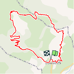
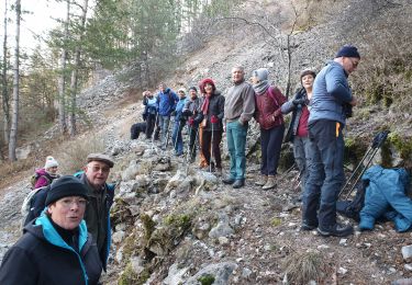
Tour Wandern von 12,8 km verfügbar auf Provence-Alpes-Côte d'Azur, Alpes-de-Haute-Provence, Sausses. Diese Tour wird von eaea7charles vorgeschlagen.
Beschreibung
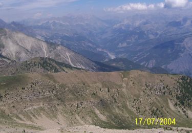
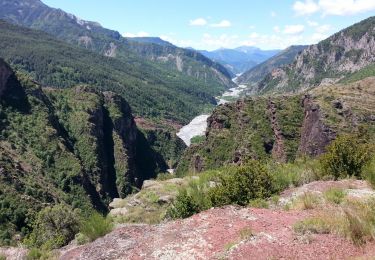
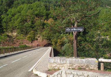
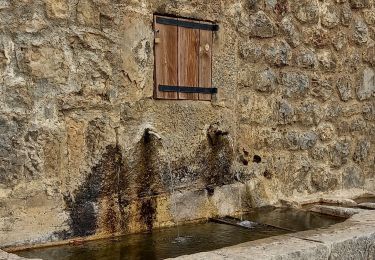
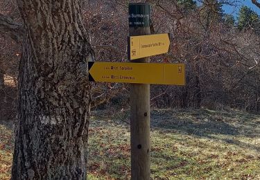
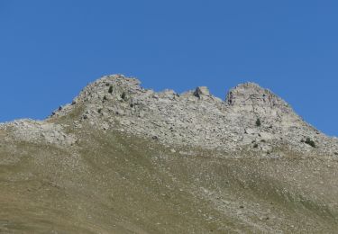
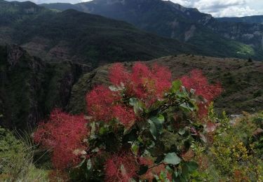
Boucle à la journée au départ de Sausses vers le col de St Pons, puis le pas de Belon. Retour par le Chabanal
Ort
Land:
France
Region :
Provence-Alpes-Côte d'Azur
Abteilung/Provinz :
Alpes-de-Haute-Provence
Kommune :
Sausses
Standort:
Unknown
Gehen Sie:(Dec)
Gehen Sie:(UTM)
322028 ; 4875303 (32T) N.
Kommentare
Touren in der Umgebung
![Tour Zu Fuß Daluis - Mont Saint-Honorat - Photo](https://media.geolcdn.com/t/375/260/fc1ba9a1-932e-4ff5-9aac-8dc781637060.jpeg&format=jpg&maxdim=2)
![Zu Fuß Zu Fuß](https://static1.geolcdn.com/sitytour/trail-icons/100.png)
Mont Saint-Honorat
Zu Fuß
Medium
Daluis,
Provence-Alpes-Côte d'Azur,
Seealpen,
France
![](/images/other/stat-length.png)
11,6 km | 26 km-effort
5h 48min
![](https://static1.geolcdn.com/siteimages/upload/files/16400158638029165_repeat_loop_refresh_sync_direction_icon.png)
Ja
![Tour Wandern Daluis - Daluis - Point Sublime - 4 km 150m - 2016 06 17 - Photo](https://media.geolcdn.com/t/375/260/ext.jpg?maxdim=2&url=https%3A%2F%2Fservices.sitytrail.com%2FGeolivesWS%2FDownloadMedia.ashx%3FTrailID%3D597790%26Media%3Dfix__20160617120004.jpg)
![Wandern Wandern](https://static1.geolcdn.com/sitytour/trail-icons/101.png)
Daluis - Point Sublime - 4 km 150m - 2016 06 17
Wandern
Einfach
Daluis,
Provence-Alpes-Côte d'Azur,
Seealpen,
France
![](/images/other/stat-length.png)
4,9 km | 8,5 km-effort
2h 10min
![](https://static1.geolcdn.com/siteimages/upload/files/16400158638029165_repeat_loop_refresh_sync_direction_icon.png)
Ja
![Tour Wandern Daluis - Gorges de Daluis - Photo](https://media.geolcdn.com/t/375/260/ext.jpg?maxdim=2&url=https%3A%2F%2Fstatic1.geolcdn.com%2Fsiteimages%2Fupload%2Ffiles%2F1553511878bg_sport_marche.png)
![Wandern Wandern](https://static1.geolcdn.com/sitytour/trail-icons/101.png)
Gorges de Daluis
Wandern
Medium
(3)
Daluis,
Provence-Alpes-Côte d'Azur,
Seealpen,
France
![](/images/other/stat-length.png)
8,9 km | 16 km-effort
3h 30min
![](https://static1.geolcdn.com/siteimages/upload/files/16400158638029165_repeat_loop_refresh_sync_direction_icon.png)
Ja
![Tour Wandern Daluis - Gorges de Daluis - Photo](https://media.geolcdn.com/t/375/260/617cb6d2-42fa-4d55-b1a3-65b3424d4778.jpg&format=jpg&maxdim=2)
![Wandern Wandern](https://static1.geolcdn.com/sitytour/trail-icons/101.png)
Gorges de Daluis
Wandern
Medium
Daluis,
Provence-Alpes-Côte d'Azur,
Seealpen,
France
![](/images/other/stat-length.png)
14,2 km | 25 km-effort
5h 45min
![](https://static1.geolcdn.com/siteimages/upload/files/16400158638029165_repeat_loop_refresh_sync_direction_icon.png)
Ja
![Tour Wandern Saint-Léger - Tete de Pibossan Col de Roua depuis ST Leger - Photo](https://media.geolcdn.com/t/375/260/9aee2a88-acc3-4522-8a50-f8a6868f4421.jpg&format=jpg&maxdim=2)
![Wandern Wandern](https://static1.geolcdn.com/sitytour/trail-icons/101.png)
Tete de Pibossan Col de Roua depuis ST Leger
Wandern
Sehr schwierig
Saint-Léger,
Provence-Alpes-Côte d'Azur,
Seealpen,
France
![](/images/other/stat-length.png)
18,8 km | 33 km-effort
7h 32min
![](https://static1.geolcdn.com/siteimages/upload/files/16400158638029165_repeat_loop_refresh_sync_direction_icon.png)
Ja
![Tour Wandern Entrevaux - Bas-Agnerc Le Pelau - Photo](https://media.geolcdn.com/t/375/260/b41cf4e2-6f50-4f00-856c-4750147829e0.jpg&format=jpg&maxdim=2)
![Wandern Wandern](https://static1.geolcdn.com/sitytour/trail-icons/101.png)
Bas-Agnerc Le Pelau
Wandern
Medium
Entrevaux,
Provence-Alpes-Côte d'Azur,
Alpes-de-Haute-Provence,
France
![](/images/other/stat-length.png)
14,1 km | 26 km-effort
6h 35min
![](https://static1.geolcdn.com/siteimages/upload/files/16400158638029165_repeat_loop_refresh_sync_direction_icon.png)
Ja
![Wandern Wandern](https://static1.geolcdn.com/sitytour/trail-icons/101.png)
Mont Saint Honorat
Wandern
Medium
Daluis,
Provence-Alpes-Côte d'Azur,
Seealpen,
France
![](/images/other/stat-length.png)
12,2 km | 26 km-effort
5h 48min
![](https://static1.geolcdn.com/siteimages/upload/files/16400158638029165_repeat_loop_refresh_sync_direction_icon.png)
Ja
![Tour Wandern Daluis - Gorges du Daluis - Photo](https://media.geolcdn.com/t/375/260/38db2acd-ddab-438c-8fd8-215a6512b64e.jpg&format=jpg&maxdim=2)
![Wandern Wandern](https://static1.geolcdn.com/sitytour/trail-icons/101.png)
Gorges du Daluis
Wandern
Medium
Daluis,
Provence-Alpes-Côte d'Azur,
Seealpen,
France
![](/images/other/stat-length.png)
13,3 km | 23 km-effort
4h 41min
![](https://static1.geolcdn.com/siteimages/upload/files/16400158638029165_repeat_loop_refresh_sync_direction_icon.png)
Ja
![Tour Wandern Daluis - Daluis Aiguille - Photo](https://media.geolcdn.com/t/375/260/a8e0785a-58fe-46c7-81f0-8b3b9bb47941.jpg&format=jpg&maxdim=2)
![Wandern Wandern](https://static1.geolcdn.com/sitytour/trail-icons/101.png)
Daluis Aiguille
Wandern
Sehr leicht
Daluis,
Provence-Alpes-Côte d'Azur,
Seealpen,
France
![](/images/other/stat-length.png)
6,5 km | 11,9 km-effort
3h 2min
![](https://static1.geolcdn.com/siteimages/upload/files/16400158638029165_repeat_loop_refresh_sync_direction_icon.png)
Ja